A radar altimetry system based on gnss signals and its application method

A signal and radar technology, applied in the field of radar altimetry system, can solve the problems of high cost, low time resolution, and low observation time resolution, and achieve the effect of low cost, long observation time, and large coverage

Inactive Publication Date: 2018-06-26
HUBEI UNIV
View PDF6 Cites 1 Cited by
  • Summary
  • Abstract
  • Description
  • Claims
  • Application Information

AI Technical Summary

Problems solved by technology

The spaceborne interferometric synthetic aperture radar system can perform efficient and accurate height map reconstruction. However, the system has the following four significant technical limitations:
[0004] 1) Single observation angle: Usually there are only one or two spaceborne radar satellites, which can only provide observation from a single angle
[0005] 2) Low time resolution of observation: Spaceborne radar satellite revisit period is usually long, resulting in low time resolution
[0006] 3) Insufficient system stability: The development history of spaceborne radar satellites is short, and its stability and actual performance need time to be verified
[0007] 4) High cost of use: spaceborne radar satellites are active radars, and the cost, launch and maintenance costs are extremely expensive

Method used


Image

  • A radar altimetry system based on gnss signals and its application method
  • A radar altimetry system based on gnss signals and its application method
  • A radar altimetry system based on gnss signals and its application method

Examples


Embodiment Construction

[0041] In order to better understand the present invention, the content of the present invention is further illustrated below in conjunction with the examples, but the content of the present invention is not limited to the following examples. Those skilled in the art can make various changes or modifications to the present invention, and these equivalent forms are also within the scope of the claims listed in this application.

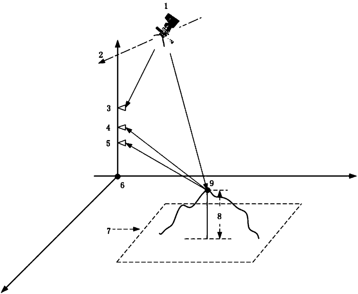
[0042] Such asfigure 1 As shown, the basic principle of the radar altimetry system based on GNSS signals of the present invention is: assume that the receiver and the observation area are in the three-dimensional local coordinates with the local coordinate origin 6 as the origin, and 7 is the entire observation area. The single-point target 9 to be measured is a certain point target in the entire observation area 7 , and the height relative to the ground plane of the local coordinates is the height 8 of the target to be measured. The present invention ...


PUM


Abstract

The invention discloses a GNSS-based radar height finding system and a using method thereof. The system comprises a signal hardware receiver and a server, wherein the signal hardware receiver is provided with three channels, respectively, a GNSS channel, a main radar channel and an auxiliary radar channel; each channel sequentially comprises an antenna assembly, a low-noise amplifier assembly, a frequency mixer assembly, a first-stage microwave signal source assembly, a band pass filter assembly, a power amplifier assembly, a second-stage microwave signal source assembly, a low pass filter assembly, a quadrature demodulator assembly, and an analog-to-digital converter assembly according to a signal passing direction. Signals of the three channels pass through the analog-to-digital converter assemblies and then together enter a data collector assembly. A data acquisition control software module, a signal pretreatment software module, a two-dimensional imaging software module and a coherent processing software module are loaded on the server. The system of the invention can solve technical limitations of single observation angle, expensive employment, long revisit period and the like in the current spaceborne radar height finding system.

Description

technical field [0001] The invention relates to a radar altimetry system based on GNSS signals and its use method, in particular to a system and its use method which use GNSS signals to perform radar imaging of target areas, and then use radar images to measure ground heights and use methods thereof, belonging to radar technology field. Background technique [0002] In recent years, the field of high-resolution earth observation remote sensing has been a hot spot in the international radar community. Researchers hope to obtain efficient and accurate ground digital height maps. Digital height maps are widely used. In military terms, digital height maps can provide very rich battlefield information and assist commanders to participate in the formulation and decision-making of tactics. In terms of national economic construction, digital height maps can be used for site selection planning of large-scale construction projects such as reservoirs and power plants. In terms of sci...

Claims


Application Information

Patent Timeline
Patent Type & Authority Patents(China)
IPC IPC(8): G01S13/90
CPCG01S13/90G01S13/003
Inventor 曾张帆
Owner HUBEI UNIV
Why Eureka
Try Eureka