

Circular synthetic aperture radar imaging method
A technology of synthetic aperture radar and imaging method, which is applied in the direction of reflection/re-radiation of radio waves, utilization of re-radiation, measurement devices, etc. , High interpolation accuracy, the effect of reducing the amount of calculation
Inactive Publication Date: 2017-05-31
UNIV OF ELECTRONICS SCI & TECH OF CHINA
View PDF5 Cites 19 Cited by
- Summary
- Abstract
- Description
- Claims
- Application Information
AI Technical Summary
Problems solved by technology
Both of the above two algorithms need to calculate each pixel of the image point by point, so the amount of calculation is huge, and it is not suitable for the practical application of large scenes and high resolution.
Although the imaging algorithm based on Green's function decomposition is more efficient than the previous two algorithms, the algorithm involves two-dimensional interpolation from polar coordinate signals to rectangular coordinates, resulting in imaging accuracy being affected by the interpolation algorithm, and additional interpolation errors will be introduced , thus affecting the imaging effect
Method used
View moreImage
Smart ImageViewing Examples

Examples
Embodiment
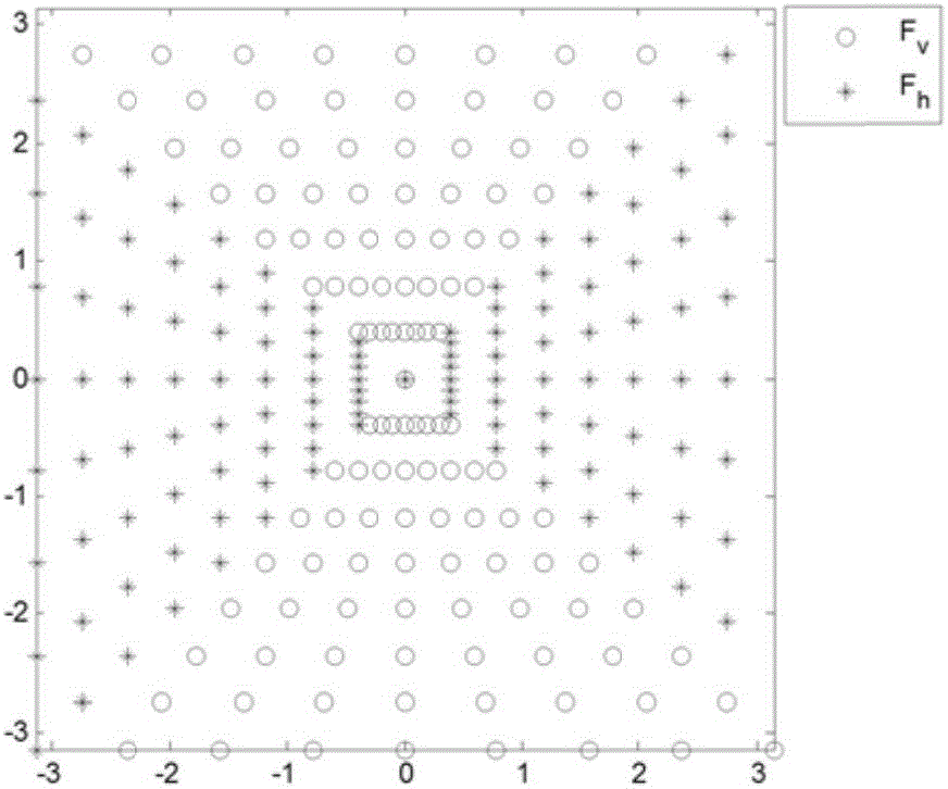
[0062] The airborne radar parameters are used for imaging simulation. The standard flight altitude of the airborne aircraft is 3000m, the pitch angle between the radar and the center of the scene is θ=30°, the center frequency is 9.6GHz, the bandwidth is 1.2GHz, and the azimuth sampling interval is 0.05°. Set up 10 point targets with the same scattering intensity, and the horizontal and vertical intervals are both 0.3m. Adopt the imaging result that the present invention obtains as Figure 6 shown. It can be seen from the imaging results that the imaging results based on the pseudo-polar coordinate Fourier transform of the present invention can realize high-efficiency and high-resolution imaging.
Login to View More PUM
 Abstract
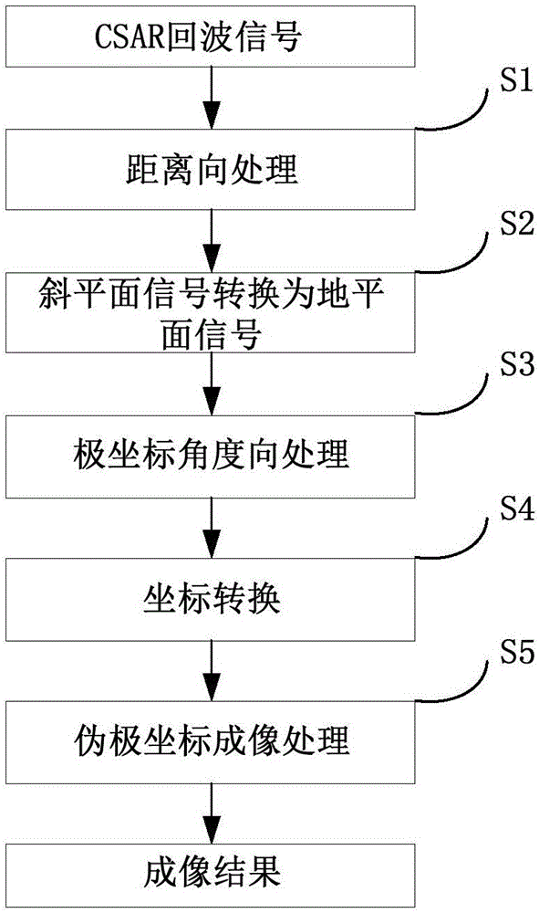
The invention discloses a circular synthetic aperture radar imaging method, belonging to the technical field of electronic signal processing. The invention relates to a spatial remote sensing and air-to-ground observation information processing technology, in particular to an onboard circular synthetic aperture radar imaging technology. According to the imaging method, an original oblique plane echo is mapped to the ground plane by solving the inverse of a system kernel function, and the distribution of signals in a wave number domain is obtained by multiplying an azimuth frequency domain with a reference function, so that plane wave approximation is avoided, the problem that the size of an imaging area of the traditional polar format algorithm is limited can be solved, and the imaging of a large imaging scene can be realized; pseudo-polar coordinates are used for replacing rectangular coordinates as an intermediate interpolation transition matrix, and the distribution density characteristic of the signals in the wave number domain is considered, so that the interpolation precision is higher, the obtained image resolution is higher, and the high resolution imaging can be realized; the imaging process only involves one-dimensional interpolation, and fast algorithms such as chirp z transform (CZT) and inverse fast Fourier transform (IFFT) are adopted, so that the method has very high computational efficiency and can realize rapid imaging.
Description
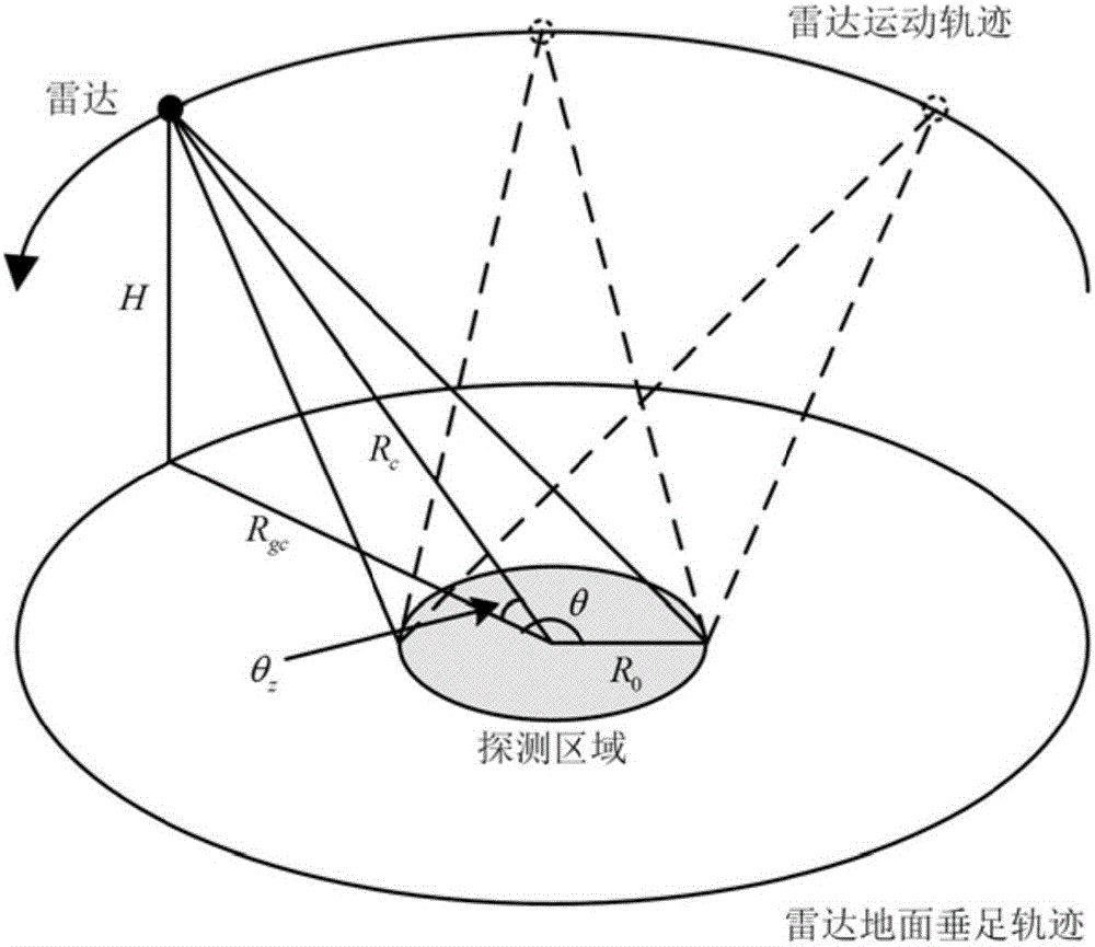
technical field [0001] The invention belongs to the technical field of electronic signal processing, relates to space remote sensing and space-to-earth observation information processing technology, in particular to an airborne circular synthetic aperture radar (Circular Synthetic Aperture Radar, CSAR) imaging technology. Background technique [0002] SAR is an important milestone in the development of radar technology in the 20th century. It uses the correlation of radar echo signals to accumulate the Doppler frequency shift of echo signals during radar movement, and synthesizes an equivalent radar aperture in the direction of radar movement. Realize high-resolution imaging in azimuth. Because SAR adopts an active working mode, it performs imaging processing on the reflected echoes of electromagnetic waves emitted by itself, and is not limited by external environments such as light and temperature. It can realize all-day and all-weather regional monitoring and imaging, and ...
Claims
Login to View More Application Information
Patent Timeline
 Patent Type & AuthorityApplications(China)
IPC IPC(8): G01S13/90
CPCG01S13/90G01S13/9088
Inventor闵锐胡睿智杨晓波李晋皮亦鸣
OwnerUNIV OF ELECTRONICS SCI & TECH OF CHINA