Method for constructing river channel data based on digital elevation model

A digital elevation model and elevation data technology, which is applied in the fields of electrical digital data processing, image data processing, special data processing applications, etc., can solve the problems of difficulty in obtaining DEM data, low popularization, and poor conditions, and achieves improvement that cannot be carried out. The situation of two-dimensional flooding simulation, the effect of easy availability of existing data and simple method

Active Publication Date: 2019-10-15
SHANGHAI MARITIME UNIVERSITY
View PDF2 Cites 8 Cited by
  • Summary
  • Abstract
  • Description
  • Claims
  • Application Information

AI Technical Summary

Problems solved by technology

DEM data generation is developed from artificial measurement to satellite telemetry. Currently, elevation data used for hydrological research are mainly global DEM data provided by foreign space satellite telemetry. Popular data include SRTM DEM data and ASTER GDEM data, etc. , and the high-precision DEM data of these satellites are often difficult to obtain domestically. At present, the maximum accuracy that can be easily obtained is 30m×30m
In hydrological research, the original data are often interpolated, resampled or corrected according to the scale of the study. Therefore, the two-dimensional data extracted based on the computer, including the width of the channel, often differs from the real channel shape. In addition, in some hydrodynamics-based The river channel DEM with bathymetry data is needed in the flood submersion range simulation. A common method at present is to set up multiple cross-section locations along the river flow direction, measure the cross-section of the river channel and draw the cross-section shape, and based on hydrodynamics, the One-dimensional flood process water level change simulation is carried out on the cross-section; in the construction of two-dimensional simulation data, the boundary line connection is often used to construct the channel without considering the change between the sections. This method ignores the curvature of the channel between the two sections and directly connects the strong bend It often also distorts the established river data
Based on the measured data, this method can more accurately simulate the change of the lateral water level of the section, but compared to the longitudinal length of the river, the simulation of a simple cross section or the channel constructed by ignoring the changes of the bottom slope and curvature between the sections will not be effective based on the water level. There are certain limitations in the dynamic flood simulation, and the workload and cost of measuring large sections based on this method are relatively large. The conditions in complex mountainous areas and the middle and upper reaches of rivers are harsh, and it is difficult to measure manually. Therefore, its generalization is small. It is difficult to establish relevant data without measured data; however, a two-dimensional inundation simulation based on hydraulics must require continuous channel data with a real shape. At present, there is no better method to establish a smooth and reasonable river bottom elevation. , river bed boundary shape real continuous river channel DEM data
Therefore, in the absence of measured data on the basis of existing DEMs, the inability to establish channel DEM data with real shapes limits the simulation of flooded areas based on hydrodynamic models, and at the same time cannot meet the high requirements of distributed hydrological models. The requirement of high-precision watershed topographic features for river channel grids is not conducive to domestic flood simulation research and the development of distributed hydrological models

Method used


Image

  • Method for constructing river channel data based on digital elevation model
  • Method for constructing river channel data based on digital elevation model
  • Method for constructing river channel data based on digital elevation model

Examples


Embodiment Construction

[0053] The present invention will be further elaborated below by describing a preferred specific embodiment in detail in conjunction with the accompanying drawings.

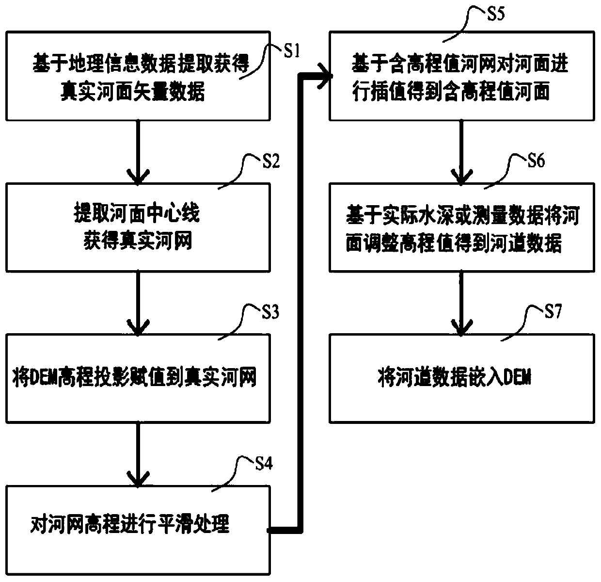
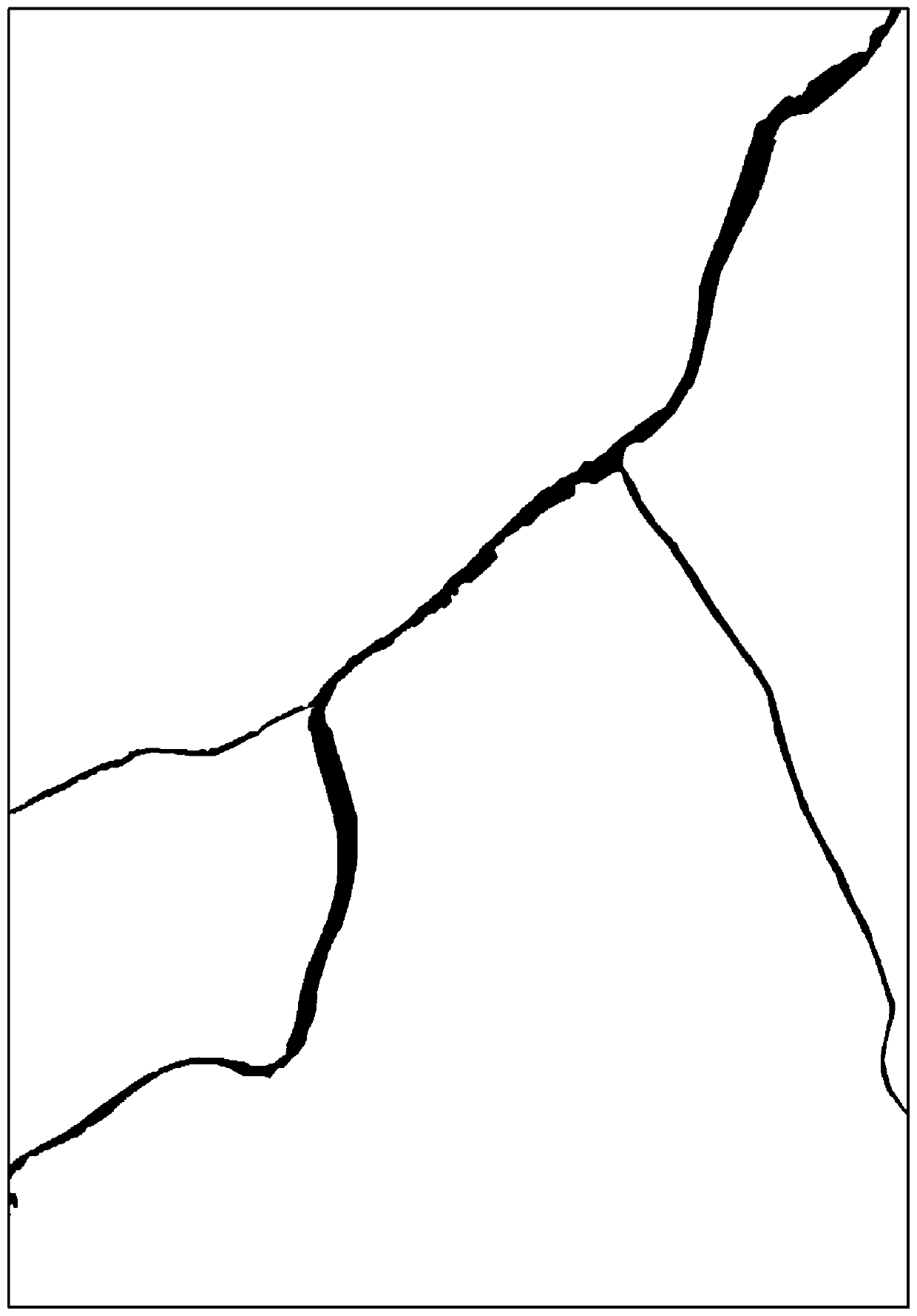
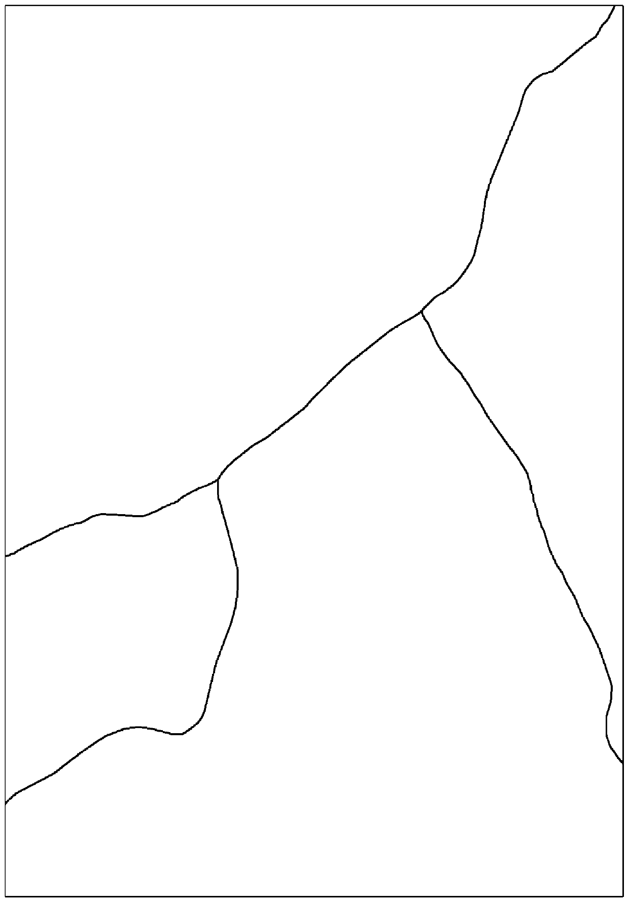
[0054] Such as figure 1 As shown, it is an execution flowchart of the method for constructing river channel data based on a digital elevation model of the present invention. In this embodiment, the Wende River Basin in Jilin Province is taken as an example to construct the DEM river channel data of the watershed. The original DEM data of this watershed adopts the 90m resolution SRTM (ShuttleRadar Topography Mision, that is, the Space Shuttle Radar Topography Mission) DEM data jointly provided by the United States Space Deployment (NASA) and the National Bureau of Mapping of the Ministry of National Defense (NIMA). The water depth of the Wende River section in Yongji County is 6m, and the channel data of this section are needed for flood flooding simulation. The specific construction method is as follows:

[0055...


PUM


Abstract

The invention discloses a method for constructing river channel data based on a digital elevation model. According to the algorithm, through available DEM data, according to real water system distribution and shape, river channel depth data or section data are combined, ArcGIS, remote sensing image processing system software, hydrological processing software and the like are combined, interpolation calculation is reasonably carried out, and river channel DEM data with smooth and reasonable river bottom elevation and real and continuous river bed boundary shape are constructed. The method has the advantages that the condition that two-dimensional flooding simulation cannot be carried out under the condition that no measured data exists at present is well improved, and data support is provided for subsequent hydrological modeling or hydrodynamic simulation.

Description

technical field [0001] The invention relates to the technical field of hydrology, in particular to a method for constructing river course data based on a digital elevation model. Background technique [0002] my country has a vast territory, diverse terrain, and complex geological structures. The resulting large and small river systems are also diverse. The main types are dendritic water systems, lattice water systems, reticular water systems, and radial water systems. The river catchment area surrounded by the watershed also varies in size and shape due to geographical and climatic conditions and the size of the river. At present, the drainage area in China is 200km 2 to 3000km 2 There are nearly 9,000 small and medium watersheds. Since ancient times, my country's observation and research on rivers has gradually developed from eyes and experience to tools and technologies, mainly including drainage channels, flood control and disaster reduction, hydraulic transportation, ...

Claims


Application Information

Patent Timeline
Patent Type & Authority Applications(China)
IPC IPC(8): G06F17/50G06T17/05
CPCG06T17/05G06T2210/04G06F30/20
Inventor 孔乔丁永生王琰
Owner SHANGHAI MARITIME UNIVERSITY
Why Eureka
Try Eureka