GPU-based large-scale terrain real-time drawing method

A large-scale terrain and real-time rendering technology, which is applied in graphics and image conversion, image data processing, instruments, etc., can solve problems such as area changes and small deformations, and achieve the effects of uniform size and format, convenient management, and reduced algorithm complexity

Pending Publication Date: 2020-02-28
SICHUAN UNIV
View PDF11 Cites 3 Cited by
  • Summary
  • Abstract
  • Description
  • Claims
  • Application Information

AI Technical Summary

Problems solved by technology

Projecting a curved surface onto a flat surface tends to deform, and the area often changes, and many earth projection algorithms fail

Method used


Image

  • GPU-based large-scale terrain real-time drawing method
  • GPU-based large-scale terrain real-time drawing method
  • GPU-based large-scale terrain real-time drawing method

Examples


Embodiment 1

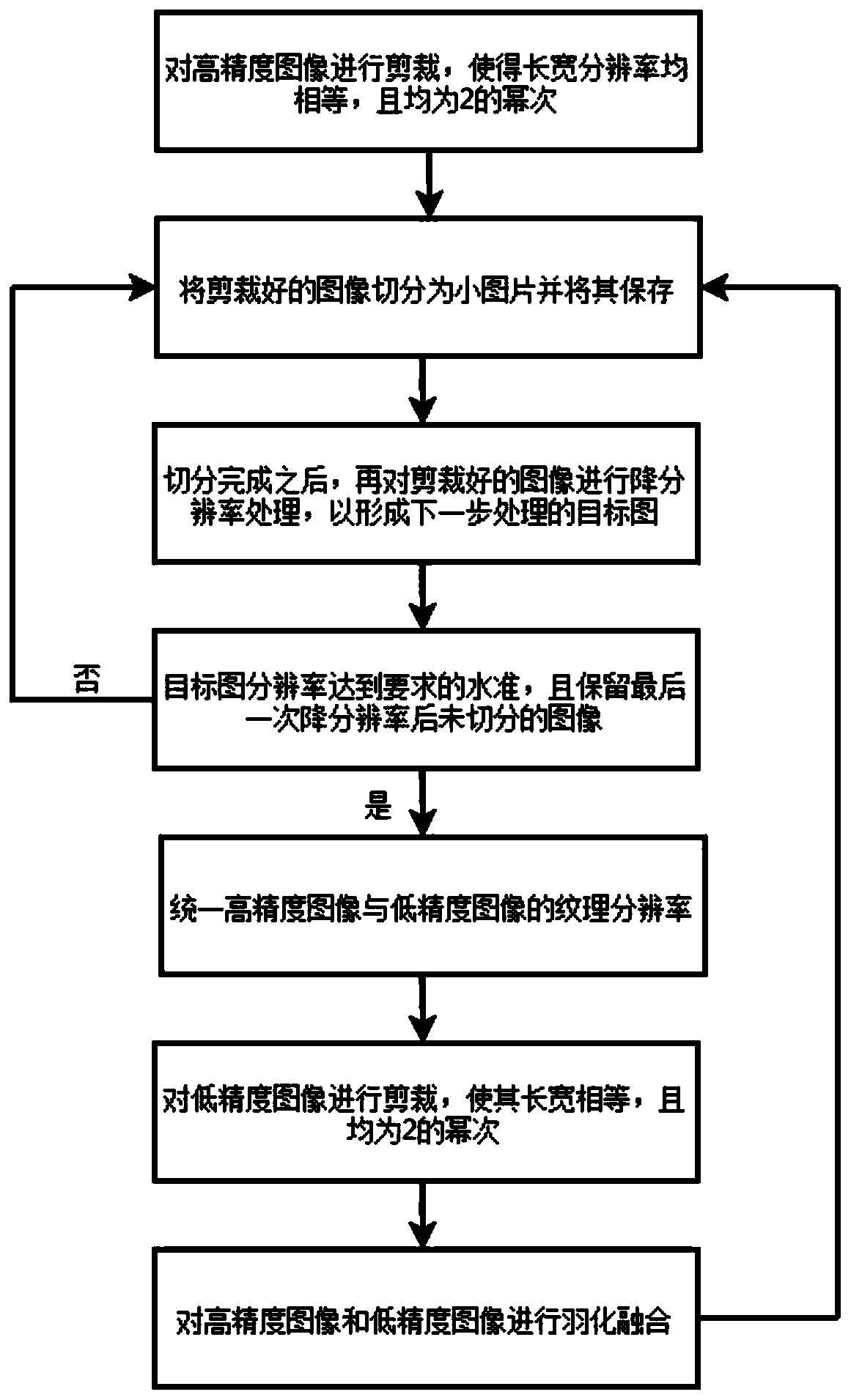
[0065] A large-scale terrain real-time rendering method based on GPU, which generates terrain model vertices, and sends the vertices from the CPU end to the processing pipeline of the GPU with the handset by choosing OpenGL as the underlying interface language, using terrain multi-level of detail LOD technology To draw a terrain grid, the terrain drawing Geometry Clipmap algorithm in the LOD technology is selected as the basis for terrain drawing, and the earth image texture needs to be processed, and the GPU first uses the NVIDIA GeForce6800 graphics card:

[0066] S1: Acquire texture images of different resolutions on the earth area; in this embodiment, obtain texture images by using virtual earth software Google earth, Google earth is a virtual earth software developed by Google, by combining satellite remote sensing images, GIS And other data are deployed on a virtual three-dimensional earth model to display earth information to users.

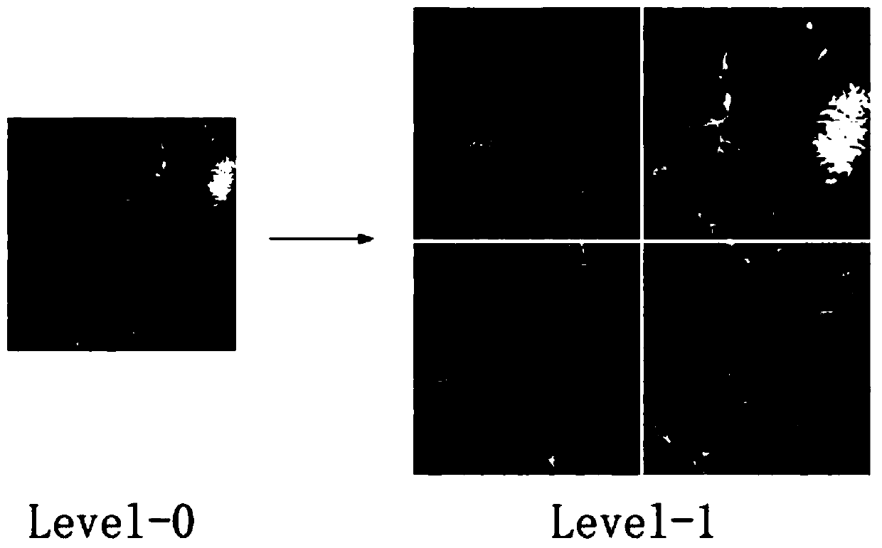
[0067] S2: The texture image is div...

Embodiment 2

[0095] The real-time rendering method of large-scale terrain based on GPU, the difference between the second embodiment and the first embodiment is that, as Figure 7 As shown, a triangular mesh in the form of a multi-layer pyramid is constructed according to the Geometry Clipmap algorithm in the prior art, and the drawing speed of the triangular mesh is accelerated by using the Triangle-strip method. Such as Figure 8 As shown, the single-layer GeometryClipmap grid is divided into 19 parts, where:

[0096] Parts 1-16 are all 16 regular quadrilateral grids, and the 16 grids form a circle around the Geometry Clipmap grid; among them, each block in parts 1-12 is a square grid with 64*64 vertices , each block in parts 13-16 is a rectangular grid with 64*3 vertices;

[0097] Part 17 is the L-shaped area. The L-shaped area is attached to the inner layer surrounded by 16 grids. There are four different ways for the L-shaped area to be attached to the inner layer, which needs to be...


PUM


Abstract

The invention belongs to the technical field of computer graphics, and discloses a GPU-based large-scale terrain real-time drawing method, which comprises the following steps: selecting a Geometric Clipmap algorithm in an LOD technology as a terrain drawing basis, and processing the texture of an earth image: obtaining texture images with different resolutions on an earth region; capturing and reserving screenshots of the texture images one by one according to the texture information of the small areas; splicing the texture information of the small areas into a texture map; dividing the texture map into different levels of small images which are consistent in size, wherein the small images comprise a high-precision image and a low-precision image corresponding to the high-precision image;resetting the precision to obtain a low-precision image, and correspondingly processing the high-precision image and the low-precision image to obtain all required terrain texture data; and loading the terrain texture data to a GPU. According to the scheme, a whole set of terrain texture obtaining and processing flow is provided, finally generated texture images are uniform in size and format, andprogram management, loading and use are facilitated.

Description

technical field [0001] The invention belongs to the technical field of computer graphics, and in particular relates to a GPU-based large-scale terrain real-time rendering method. Background technique [0002] For the training of pilots, people propose to use flight simulators to simulate the flight process, so as to ensure the safety and reliability of such training for pilots. As a window for direct visual interaction with the pilot, the research and development of the flight simulator visual system has become a top priority. Real-time rendering of terrain has always been a very important aspect in flight vision systems. [0003] In order to simulate the flight process of an aircraft, the terrain needs to have a large range of representation and sufficient response update speed. For this reason, the existing technology uses terrain LOD technology to simplify the terrain grid to speed up terrain rendering. The full name of LOD (level of detail) Level Of Details refers to u...

Claims


Application Information

Patent Timeline
IPC IPC(8): G06T3/40G06T5/50G06T1/20
CPCG06T3/4038G06T5/50G06T1/20G06T2207/20132G06T2207/20021G06T2207/20221G06T2207/30181Y02A90/10
Inventor 黄操季玉龙陈怀歆张婷婷吴志红王一周思源龚昱宁罗子奇
Owner SICHUAN UNIV
Why Eureka
Try Eureka