Satellite data fusion method and device and electronic equipment

A technology of satellite data and fusion methods, applied in the field of satellite data processing, can solve the problems of limited observation data and the inability to directly apply the data temporal and spatial resolution business system, etc., to achieve the effect of improving effectiveness

Active Publication Date: 2020-09-01
NAT SATELLITE OCEAN APPL SERVICE +2
View PDF5 Cites 1 Cited by
  • Summary
  • Abstract
  • Description
  • Claims
  • Application Information

AI Technical Summary

Problems solved by technology

However, the observation data of a single satellite remote sensing instrument within a day is limited. For example, usually only two observations can be made on the same area, which cannot be directly applied to operational systems that require high temporal and spatial resolution of data.

Method used


Image

  • Satellite data fusion method and device and electronic equipment
  • Satellite data fusion method and device and electronic equipment
  • Satellite data fusion method and device and electronic equipment

Examples


Embodiment 1

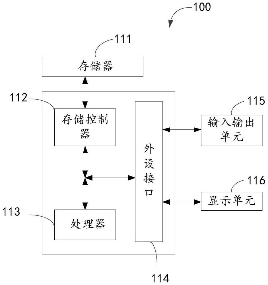
[0056] In order to facilitate the understanding of this embodiment, firstly, an electronic device for implementing the satellite data fusion method disclosed in the embodiment of the present application is introduced in detail.

[0057] like figure 1 Shown is a block diagram of the electronic device. The electronic device 100 may include a memory 111 , a storage controller 112 , a processor 113 , a peripheral interface 114 , an input and output unit 115 , and a display unit 116 . Those of ordinary skill in the art can understand that, figure 1 The shown structure is only for illustration, and does not limit the structure of the electronic device 100 . For example, the electronic device 100 may also include a ratio figure 1 more or fewer components than shown in, or with figure 1 Different configurations are shown.

[0058] The memory 111 , storage controller 112 , processor 113 , peripheral interface 114 , input / output unit 115 and display unit 116 are electrically connec...

Embodiment 2

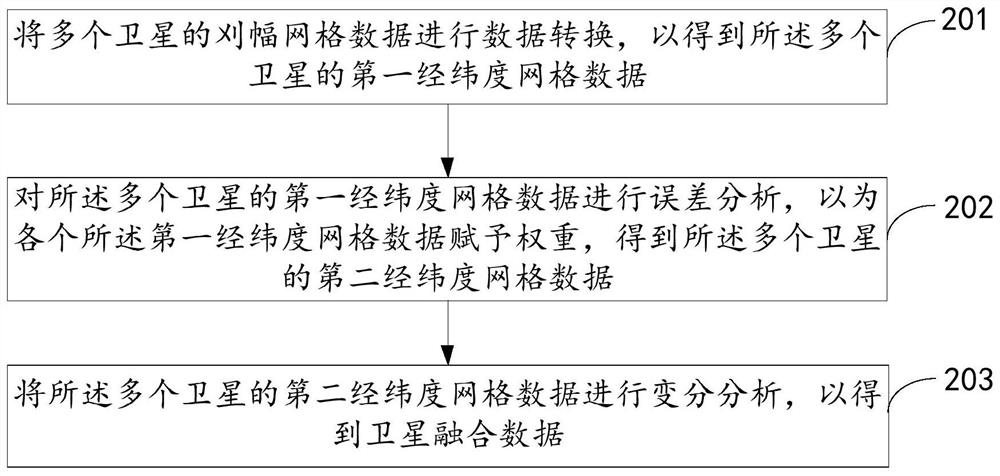
[0067] see figure 2 , is a flow chart of the satellite data fusion method provided by the embodiment of the present application. The following will be figure 2 The specific process shown will be described in detail.

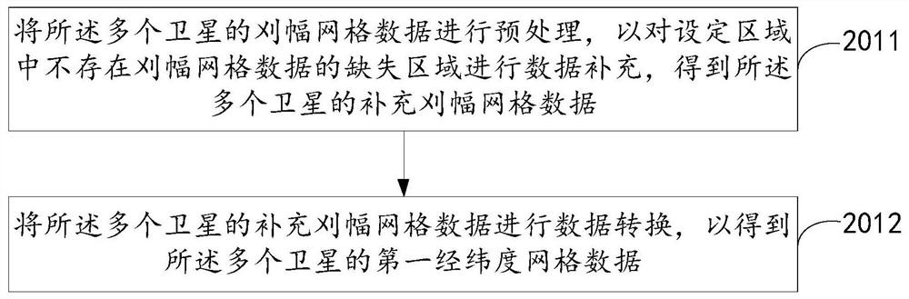
[0068] Step 201, performing data conversion on swath grid data of multiple satellites to obtain first latitude and longitude grid data of the multiple satellites.

[0069] Optionally, the grid corresponding to the above-mentioned first latitude and longitude grid data can be divided in the following manner: the interval between the longitude and latitude of the adjacent grid center is 0.25°; the starting point of the coordinate scale of longitude is 0.125°, and the end point is 359.875°, a total of 1440 points; the starting point of the latitude coordinate scale is -89.875°, the end point is 89.875°, a total of 720 points.

[0070] Optionally, the above-mentioned data collected by multiple satellites may be sea surface wind field data. In one example, the p...

Embodiment 3

[0149] Based on the same application concept, the embodiment of the present application also provides a satellite data fusion device corresponding to the satellite data fusion method. Since the problem-solving principle of the device in the embodiment of the present application is similar to the aforementioned embodiment of the satellite data fusion method, the present application For the implementation of the device in the embodiment, reference may be made to the description in the embodiment of the above method, and repeated descriptions will not be repeated.

[0150] see Figure 7 , is a schematic diagram of the functional modules of the satellite data fusion device provided in the embodiment of the present application. Each module in the satellite data fusion device in this embodiment is used to execute each step in the above method embodiment. The satellite data fusion device includes: a conversion module 301, a first analysis module 302, and a second analysis module 303...


PUM


Abstract

The invention provides a satellite data fusion method and device and electronic equipment, and the method comprises the steps: carrying out the data conversion of the swath grid data of a plurality ofsatellites, so as to obtain the first longitude and latitude grid data of the plurality of satellites; performing error analysis on the first longitude and latitude grid data of the plurality of satellites, and endowing each piece of first longitude and latitude grid data with a weight to obtain second longitude and latitude grid data of the plurality of satellites; and performing variational analysis on the second longitude and latitude grid data of the plurality of satellites to obtain satellite fusion data.

Description

technical field [0001] The present application relates to the technical field of satellite data processing, in particular, to a satellite data fusion method, device and electronic equipment. Background technique [0002] Sea surface wind field data observed by satellite microwave remote sensing instruments are playing an increasingly important role in ocean and atmospheric operational monitoring and forecasting. However, the observation data of a single satellite remote sensing instrument within a day is limited. For example, usually only two observations can be made on the same area, which cannot be directly applied to operational systems that require high temporal and spatial resolution of data. Contents of the invention [0003] In view of this, the purpose of the embodiments of the present application is to provide a satellite data fusion method, device and electronic equipment. It can reduce the single deficiency of satellite data in the existing processing method. ...

Claims


Application Information

Patent Timeline
Patent Type & Authority Applications(China)
IPC IPC(8): G06F30/23G06F111/10
Inventor 林文明邹巨洪林明森崔松雪黄磊
Owner NAT SATELLITE OCEAN APPL SERVICE
Why Eureka
Try Eureka