River virtual station water level time sequence reconstruction method and system

A virtual station and river technology, applied in the fields of hydroinformatics and remote sensing science, can solve the problems of limited water surface range and limit the promotion and application of river virtual stations, and achieve the effects of improving extraction accuracy, good applicability, and expanding monitoring potential

Active Publication Date: 2021-12-24
HOHAI UNIV +1
View PDF5 Cites 4 Cited by
  • Summary
  • Abstract
  • Description
  • Claims
  • Application Information

AI Technical Summary

Problems solved by technology

Most of the second type of algorithms are developed for lakes and reservoirs. For finer surface water bodies and rivers, the water surface range is more limited. Algorithms based purely on statistical analysis are only suitable for very large rivers due to the demand for large sample sizes.
Existing water level extraction algorithms require manual intervention or rely on fine prior knowledge, or statistical algorithms based on large samples, which greatly limits the promotion and application of river virtual station technology

Method used


Image

  • River virtual station water level time sequence reconstruction method and system
  • River virtual station water level time sequence reconstruction method and system
  • River virtual station water level time sequence reconstruction method and system

Examples


Embodiment 1

[0057] This embodiment provides a new type of intelligent and automatic water level sequence reconstruction algorithm to expand the river monitoring potential of the river virtual station water level time series reconstruction method. This method uses publicly available altimetry satellite original waveform data, water system network data, and surface water body frequency distribution maps. The main strategies such as iterative identification reconstruct high-precision long-term series of water levels, including the following processes:

[0058] Step 1. Intersect the altimetry satellite track line with the center line of the global river network to obtain the virtual station position of the river, extract the water surface range of the river according to the water body frequency map and calculate the average width of the river section, and screen the streams whose river width is greater than a certain threshold according to the average river width The location of the virtual s...

Embodiment 2

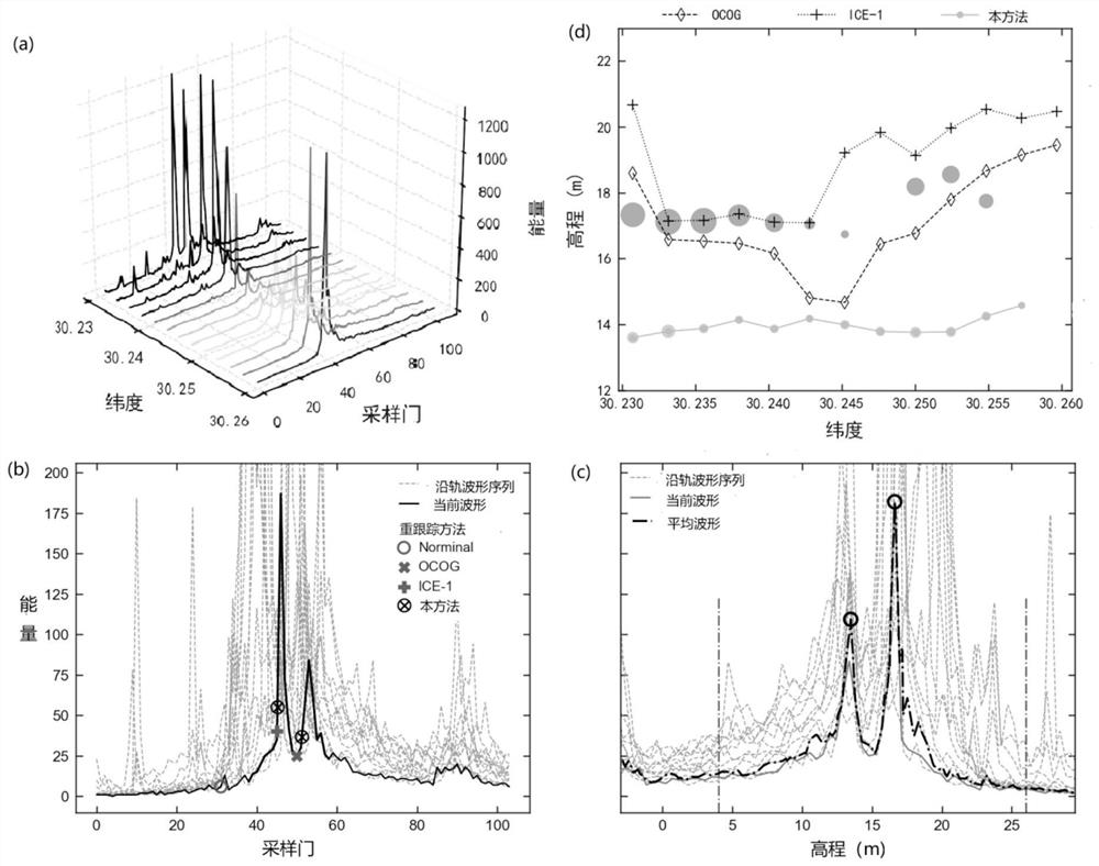
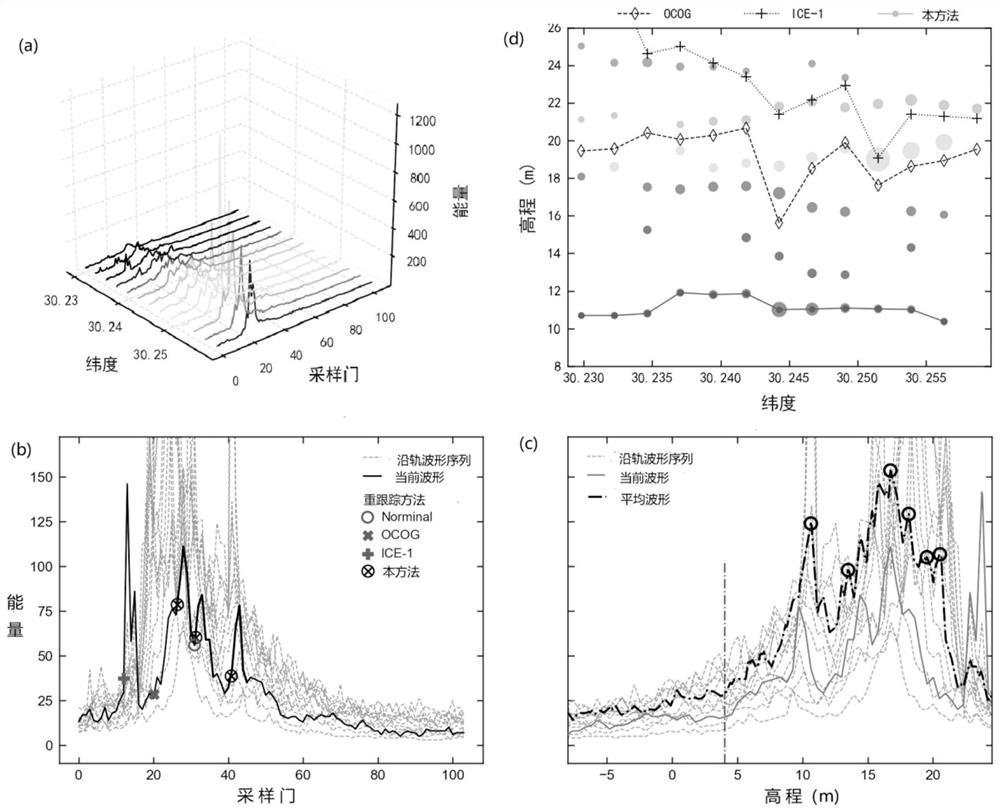
[0077] The embodiment of this application is a river virtual station near Huangshi Port Station in the Yangtze River Basin, and the water level time series of the station from 2008 to 2019 is established based on Jason2 and Jason3 satellite observation data. There are actually measured hydrological station (Huangshi Port Hydrological Station) data within 3 kilometers of the station, which is convenient for verification of the accuracy of the algorithm. Such as figure 1 As shown, the average width of this section of the river is 1.15 kilometers, and the surrounding area of ​​the river includes urban buildings, natural vegetation, lakes and reservoirs, artificial waters and other surface coverage, resulting in complex and changeable waveform shapes and amplitudes, which are very challenging in river water level extraction .

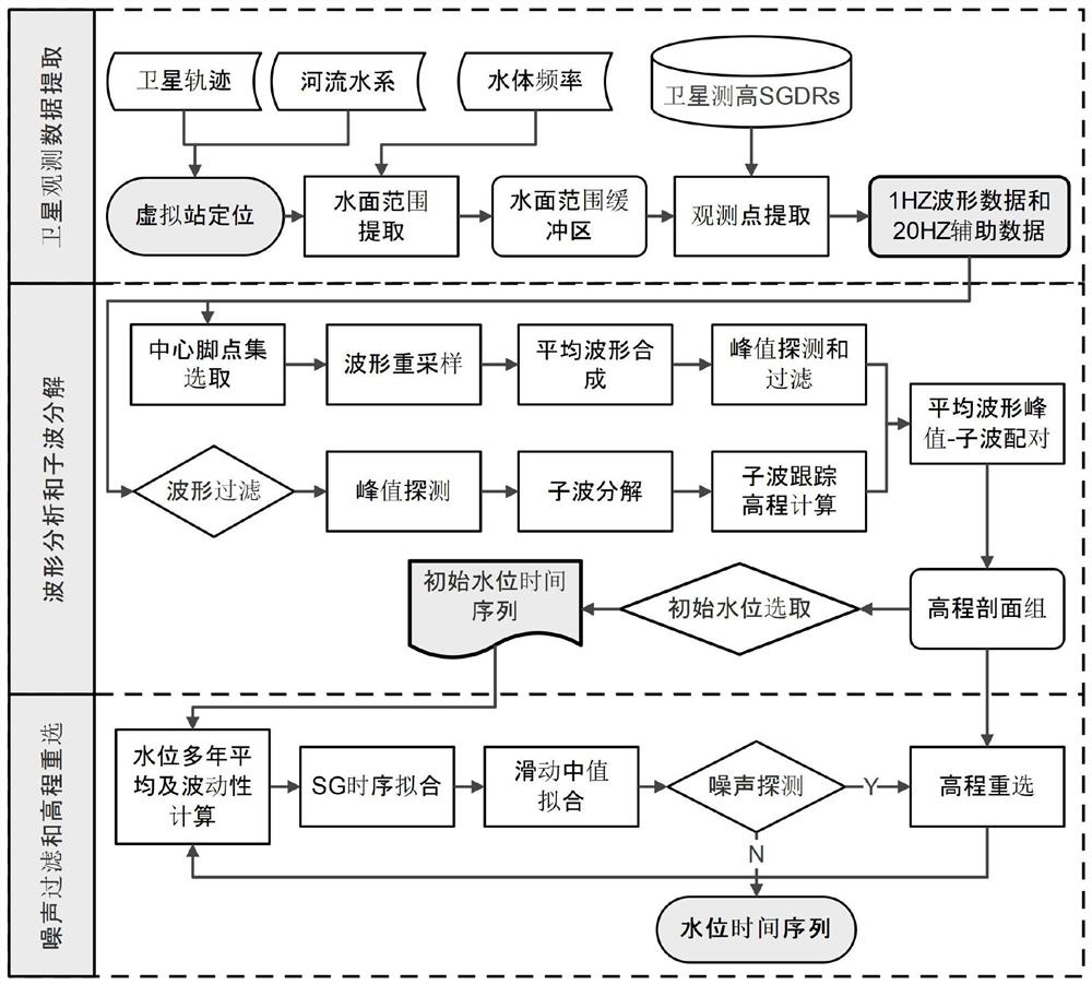
[0078] Such as figure 2 Shown is the flow chart of embodiment, and present embodiment comprises the following steps:

[0079] Step 1: Determine the loc...

Embodiment 3

[0101] This embodiment provides a time-series reconstruction system for the water level of a river virtual station, and the system includes:

[0102] Acquisition module: used to obtain satellite observation data;

[0103] Extraction module: used to determine the position and water surface range of the virtual station of the river according to the satellite observation data, define a buffer zone according to the position of the virtual station of the river and the range of the water surface, and extract all the objects in the buffer zone according to the scope of the buffer zone Radar altimetry satellite observation footprint points and their waveforms and auxiliary data;

[0104] Elevation profile module: used for waveform analysis and wavelet decomposition of all radar altimetry satellite observation footprints and their waveforms and auxiliary data in the buffer zone to obtain multiple sets of latitudinal elevation profiles;

[0105] Water surface elevation module: used to ...


PUM


Abstract

The invention discloses a river virtual station water level time sequence reconstruction method and system. The method comprises the steps of: taking an average waveform of a central foot point and an adjacent point as a reference on the basis of improved adaptive wavelet analysis, extracting a plurality of pulse peak values meeting parameter conditions, enabling the pulse peak values to be paired with wavelets of an along-rail waveform, and forming a plurality of groups of latitudinal elevation profiles, and constructing a multi-target optimization function by using wave peak energy and elevation standard error, and determining a target water surface elevation observation group; and finally, optimizing a water level elevation time sequence through time sequence noise detection and elevation reselection. According to the method, on the basis of publicly obtained satellite altimetry data and auxiliary data, automatic river virtual site water level time sequence extraction can be achieved; and the method can automatically adapt to main wave peak detection under the conditions of high noise level and multi-peak distribution, improve the river water level extraction precision under the complex earth surface condition, and provide support for applications such as river water regimen monitoring, global change and water circulation monitoring.

Description

technical field [0001] The invention relates to the fields of hydroinformatics and remote sensing science and technology, in particular to a time-series reconstruction method and system for water level of a virtual river station. Background technique [0002] Rivers carry ecological health, sustainable economic development and human well-being. Water level is one of the key elements of river water regime, which is closely related to climate change, fresh water supply, and flood disasters. Under the influence of climate change and enhanced human activities, monitoring changes in river water levels is crucial to understanding and responding to existing or potential problems such as water security, energy risks, and food security. [0003] The traditional way to obtain water level information is to set up hydrological monitoring stations for observation, but this method is limited in remote and harsh climate areas, and due to maintenance costs and labor constraints, the number...

Claims


Application Information

Patent Timeline
Patent Type & Authority Applications(China)
IPC IPC(8): G01F23/284G01S13/88
CPCG01F23/284G01S13/882Y02A90/30
Inventor 柯灵红宋春桥雍斌
Owner HOHAI UNIV
Why Eureka
Try Eureka