Method of proceeding coding designation against city and peripheral region geographical addressing object

A technology for regions and cities, applied in maps/plans/charts, traffic control systems for road vehicles, instruments, etc., can solve problems such as difficult geographical addressing, lagging behind in urban construction, and inability to directly meet addressing requirements

Inactive Publication Date: 2004-12-22
CHONGQING NORMAL UNIVERSITY
View PDF2 Cites 15 Cited by
  • Summary
  • Abstract
  • Description
  • Claims
  • Application Information

AI Technical Summary

Problems solved by technology

[0004] 1. Roads and house numbers do not contain orientation information, and it is impossible to determine the approximate orientation of the destination and its relative position in the city based on roads and house numbers;
[0005] 2. Due to the limited resolution of the city map, it is impossible to accurately locate the specific location of a geographic addressing object in the map;
[0006] 3. Due to the randomness or commerciality of the naming of roads in various cities, few people fully understand the naming rules of urban roads. Except for some important roads, it is quite difficult to find the location of a certain road on the city map;
[0007] 4. The number of roads and house numbers changes with urban construction, and the limitation period is very short. In urban construction, adjusting blocks and changing roads are very fast, while road naming and house numbers lag behind urbanization construction, making geographic addressing more difficult;
[0008] 5. The geographical addressing method of road naming and house numbering is inconvenient and intuitive for realizing digital representation and digital transmission, and is not conducive to the construction of a digital city system;
[0009] 6. The geographical addressing method based on road and house number is not conducive to the rapid adjustment and control of urban traffic by municipal authorities. Under normal circumstances, it is difficult to guide and control motor vehicle flow according to traffic flow and road changes. In special cases, It is more difficult to quickly and flexibly dredge urban traffic according to the emergency response plan
And the global positioning system GPS that is used in domestic part big city is used for determining the geographical location (longitude and latitude) of target at present, can not directly satisfy the addressing requirement in people's daily life (as how to arrive at a certain geographic addressing object? How does a certain route go?), it only solves the problem of positioning, and to complete the addressing, the support of geographic information system (GIS) is needed. Coordinate conversion, so it has the following disadvantages for the application requirements of land traffic instructions, command and geographic location addressing in cities and surrounding areas:
[0011] 1. The conversion from absolute geographic location to relative geographic coordinates relative to the city increases the complexity and cost of the system
Reduced application flexibility;
[0012] 2. After converting from the absolute geographic location to the geographic coordinates relative to the city where it is located, the traditional addressing method of road name and house number must still be used
[0013] 3. It still fails to solve the problem that the update speed of geographic information system lags behind the urban construction
[0014] 4. It is difficult for municipal authorities to quickly and flexibly guide and control the distribution of motor vehicle flow according to traffic flow and road changes. Under special circumstances, it is even more difficult to quickly and flexibly guide urban traffic according to emergency contingency plans
It is also impossible to use it to realize the urban traffic remote automatic dynamic dispatch management system that integrates traffic flow information, traffic control information, and road condition information
[0015] 5. The source of the GPS signal is controlled by the foreign government. Once a special situation occurs, if the signal is interfered, all the equipment working with the global GPS will have problems, which may endanger national security.
[0016] 6. Difficult to popularize and use on a large scale
[0019] (1) The city is artificially divided into four regions, which is inconsistent with the administrative divisions of most existing cities and is difficult to be accepted by citizens and drivers;
[0020] (2) There will be ambiguity in the geographical location markings at the junction of the four regions of the adjacent cities, and it is difficult to directly judge the geographical locations that may be close to each other from the geographical location markings
[0021] (3) Roads are marked by the method of direction indication, which cannot mark roads across different regions, nor can it mark cross-administrative routes
[0022] (4) Non-standardization, only consider the code from the city, expand the codeword by expanding the number of digits, it is possible to use codes with different structures in the same city;
[0023] (5) When processing in the computer, if consider the fixed-length code, it is not easy to coordinate the code lengths of two adjacent large and small cities, which will waste computer storage space and computing time; D crown plus digital four-quadrant coding algorithm will increase the complexity;
But geographically, the accuracy of 1° is about 1800 meters (1 degree is 110 kilometers). Therefore, the error of the absolute geographical position of the center of the city or region in the adjacent area will make the error between the boundaries of the area will greatly exceed the error of the specific location. Relative to the accuracy of encoding 10 meters, theoretically there is still the problem of adjacent area boundaries
[0027] (2) The code is inconsistent with the national GB standard administrative area code, and the administrative area code is not directly related to the latitude and longitude code; the non-disclosure of the absolute position is not easy to be widely accepted and popularized by people;
[0028] (3) Most of the cities in the country (especially the southern cities) have many bends in the roads. Coding the roads with the road axis is not only complicated but also inapplicable, and it is difficult to be accepted by citizens and municipal authorities
[0029] (4) The code is composed of 3 parts, and the code word is too long, especially the second and third parts of the geographic code and the address information of the text code are all dynamic lengths, and the expression processing in the calculation is complicated;
[0030] (5) The manual or machine collection of text addresses is complicated and the workload is huge, and the update work also increases thereupon, and the cost is high; the randomness of the "identification code" distribution in the geographic location code will also cause the current house number method to fail. Awkward

Method used


Image

  • Method of proceeding coding designation against city and peripheral region geographical addressing object
  • Method of proceeding coding designation against city and peripheral region geographical addressing object
  • Method of proceeding coding designation against city and peripheral region geographical addressing object

Examples


Embodiment 1

[0087] Embodiment 1 Geographic location segmentation marking method

[0088] As a specific embodiment, the block labeling method is described as follows.

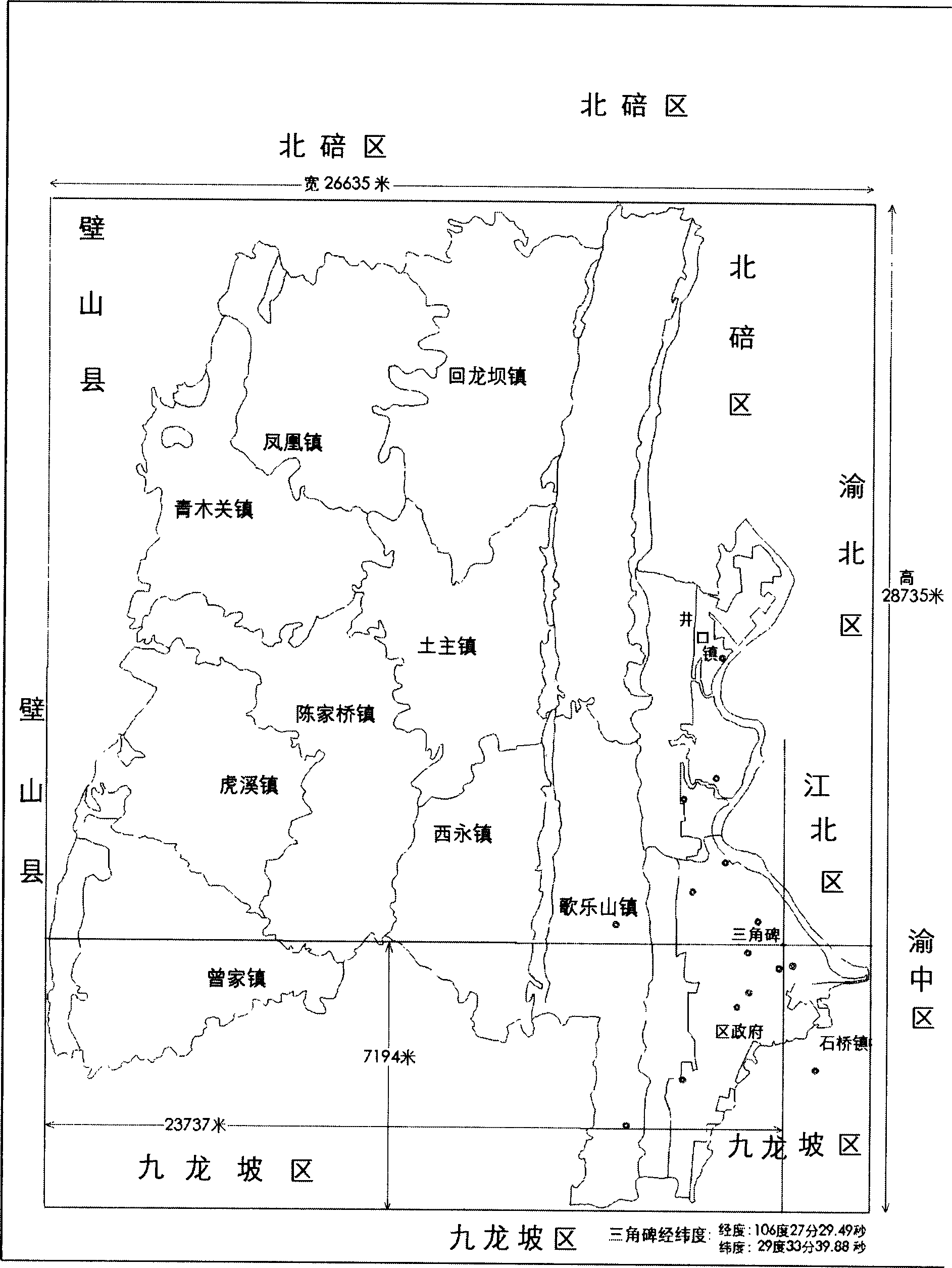
[0089] According to the GB / T2260-1995 administrative division code of the People's Republic of China, the administrative division code of Shapingba District, Chongqing City is 500106; The span in the east direction is about 26,635 meters, and the span in the south-north direction is about 28,735 meters. The recognized commercial center of Shapingba District, Chongqing City is Triangular Monument (106°27′29.49″E and 29°33′39.88″N in longitude and latitude). The farthest point is 7194 meters, see attached drawing 1.

[0090] In this embodiment, the administrative division of Shapingba District, Chongqing is divided into 25×25-meter plots by using the equal-length geographic space projection method (this patent has no limitation on the size of the divided plots). Taking the triangular monument (latitude and longitude 106°27...

Embodiment 2

[0101] Embodiment 2 Geographic location marking is used for motor vehicle traffic route marking

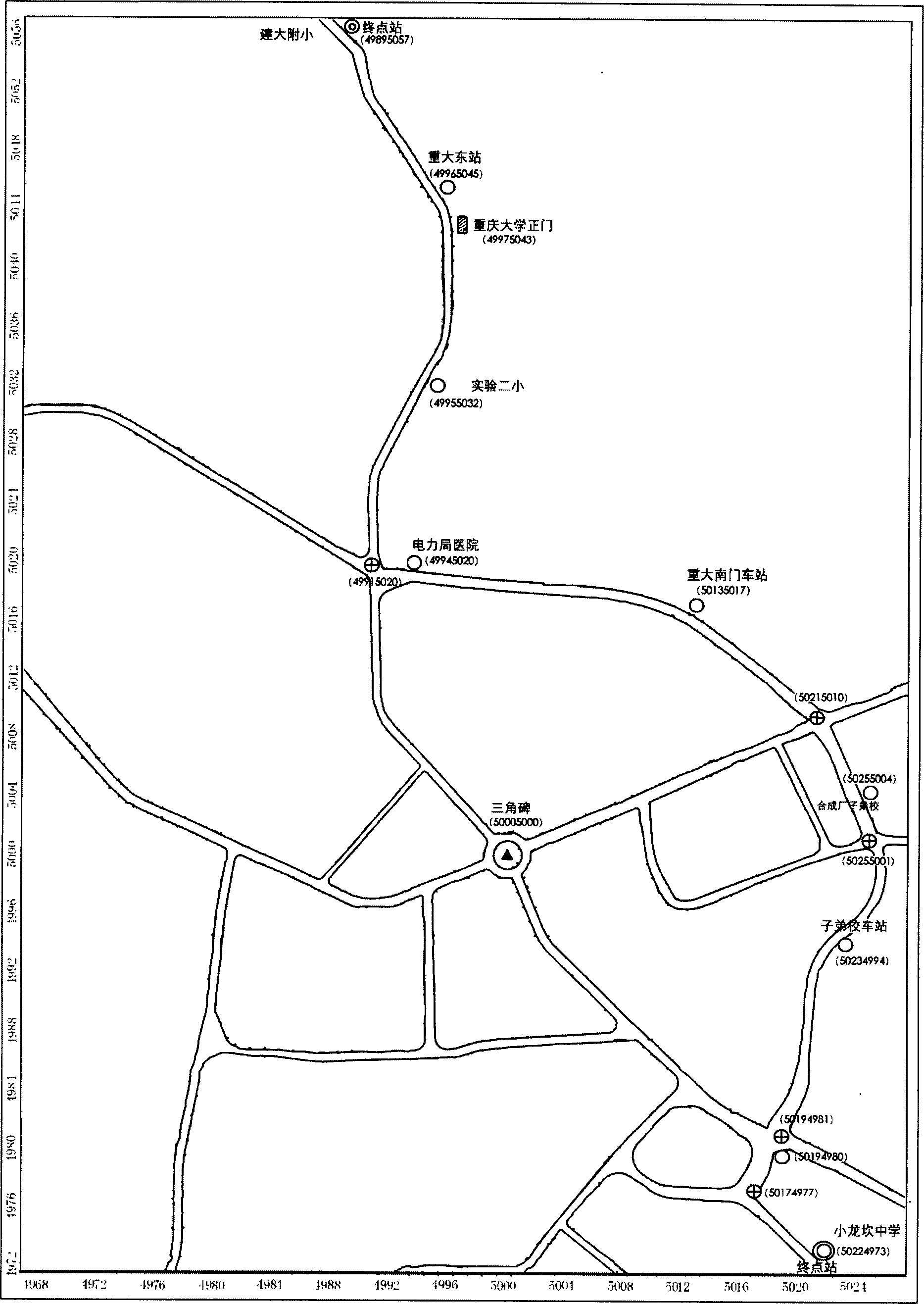
[0102] Since road intersections are also geo-addressed objects, this geo-location indication can also be used to represent or mark road routes connecting two or more geo-addressed objects. For example, it is used to mark the driving routes and stops of urban public transportation. Illustrate with accompanying drawing 3. For example, the departure station of a certain bus is Xiaolongkan Middle School, and its geographic location is marked as 50224973; the final stop is the primary school attached to Jianda University, and its geographical location is marked as 49895057, and the geographical locations of the stops along the way are respectively 50194980, 50234994, 50255004, 50135017, 49945020, 49955032, 49965045, the geographic location marks of road intersections along the way are 50174977, 50194981, 50255001, 50215010, 49915020, and you can clearly understand the operation route ...

Embodiment 3

[0103] Embodiment 3 Install intelligent road signs capable of wirelessly sending geographic location markings at road intersections or in their vicinity, and install vehicle-mounted wireless receiving devices on motor vehicles to receive geographic location markings to realize automatic navigation and command systems for motor vehicles.

[0104] Smart street signs can be divided into two categories: visible and invisible according to their appearance. In addition to wirelessly sending geographical location marks, visible smart street signs, like traditional street signs, also use text to indicate traffic information. The invisible smart street signs only have the function of wirelessly sending geographical location indications. They are small in size and can be buried near the road.

[0105] The control device of the smart road sign uses infrared or radio technology (such as Bluetooth technology) to send at least the following information to passing vehicles:

[0106] 1. Geogr...


PUM


Abstract

Marker information of geographical position obtained includes two parts: first part in utilized to distinguish counties and cities according to GB/T2260-1995 administrative division code of the People's Republic of China; second part is markers of geographical position of towns and circumference, which is divided into marked land blocks. Geographical addressable objects can be located quickly and correctly through the said marker information of geographical position. Road routes of geographical addressable objects can be built based on markers of crossroad of roads. Wireless transmitted marker information of crossroad as well as front crossroad of each road is setup on crossroad. Device capable of receiving the said information wirelessly is installed on vehicle so as to realize navigation for motor vehicles.

Description

technical field [0001] The invention belongs to the technical field of geographical location representation and labeling, and in particular relates to a geographic addressing object for a city and its surrounding areas (such as roads, intersections, stations, docks, institutional units, residential quarters, etc., referred to as geographical addressing objects) A method for identifying, marking and locating, and using it for road marking, traffic indication, and land traffic navigation related to motor vehicle navigation. technical background [0002] With the progress of society, the increasing number of cars and the continuous development of road traffic have expanded the scope of people's activities, and correspondingly put forward more requirements for geographical location. From traditional paper maps to modern GPS technology is the response to this need. In densely populated cities with complex roads and many institutions and their surrounding areas, it is an importan...

Claims


Application Information

Patent Timeline
Patent Type & Authority Applications(China)
IPC IPC(8): G01C21/32G08G1/0968G08G1/0969G09B29/00G09B29/10
Inventor 陈阿林袁从武
Owner CHONGQING NORMAL UNIVERSITY
Why Eureka
Try Eureka