System and method for enhanced data decode in a GPS receiver

a satellite navigation and data decoding technology, applied in the field of enhanced data decoding in satellite navigation receivers, can solve the problems of low signal strength conditions, inability to reliably operate below a cn0 of 26 db-hz, and the correct demodulation or decoding of ephemeris, so as to improve the sensitivity of ephemeris data decoding, and improve the probability of successful decoding

Inactive Publication Date: 2010-06-03
CSR TECH INC
View PDF0 Cites 36 Cited by
  • Summary
  • Abstract
  • Description
  • Claims
  • Application Information

AI Technical Summary

Benefits of technology

[0004]Systems and methods are disclosed herein to reliably demodulate and decode ephemeris data from a GPS satellite in low signal strength conditions. Benefits include a 95% success rate in decoding GPS ephemeris data given two frames of data at a CN0 of 23 dB-Hz. Each frame of data consists of 50 GPS data words of which the GPS ephemeris data is encapsulated in 19 words. A reduced probability of successf...

Problems solved by technology

However, there are situations when a low signal strength of the satellite signals can prevent the correct demodulation or decoding of the ephemeris data.
Low signal strength conditions can occur in challenging environments such as in urban canyons, under foliage, inside tunnels etc.
For example, conventional GPS data decode systems have not proven to be capable of operatin...

Method used


Image

  • System and method for enhanced data decode in a GPS receiver
  • System and method for enhanced data decode in a GPS receiver
  • System and method for enhanced data decode in a GPS receiver

Examples


Embodiment Construction

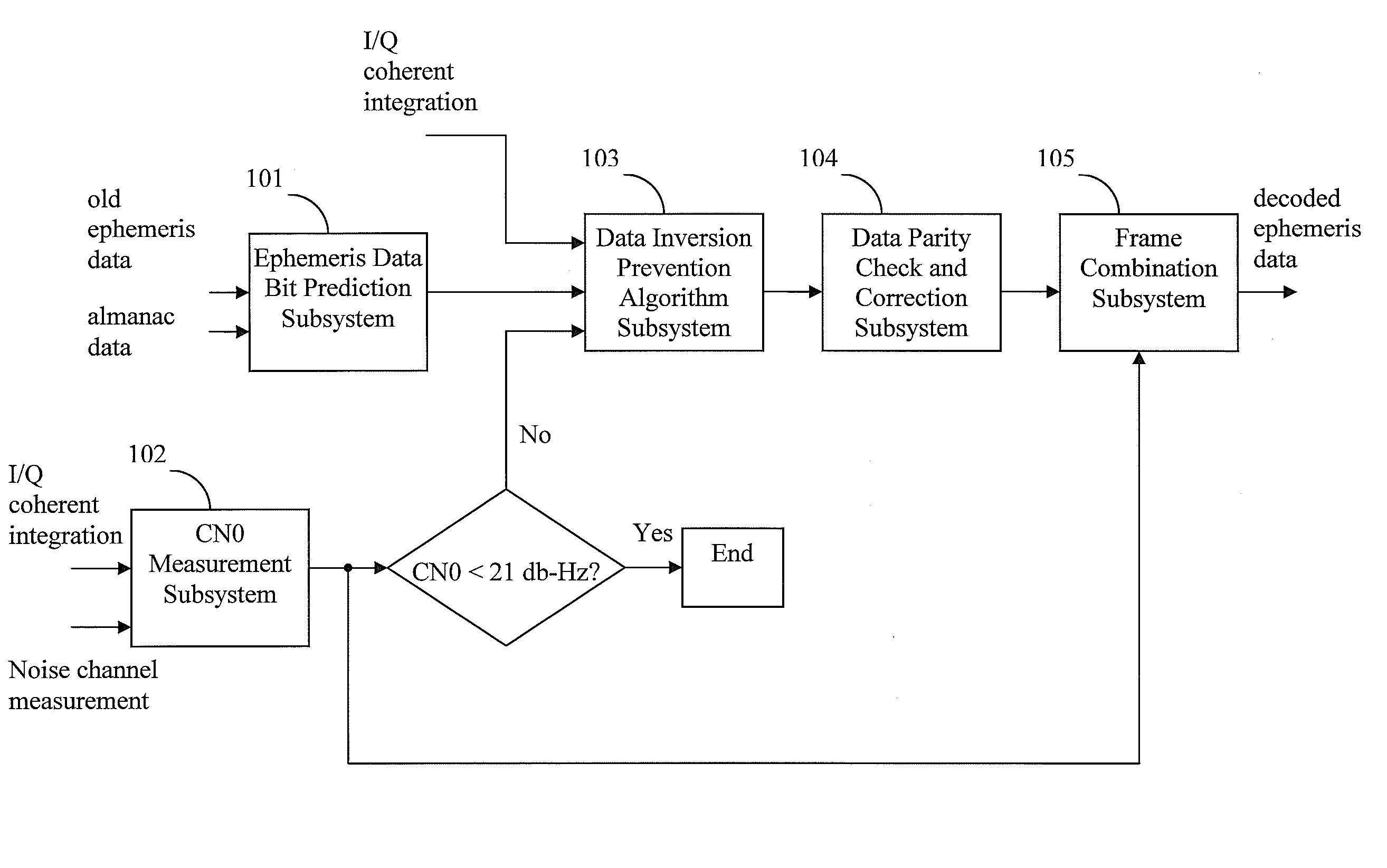
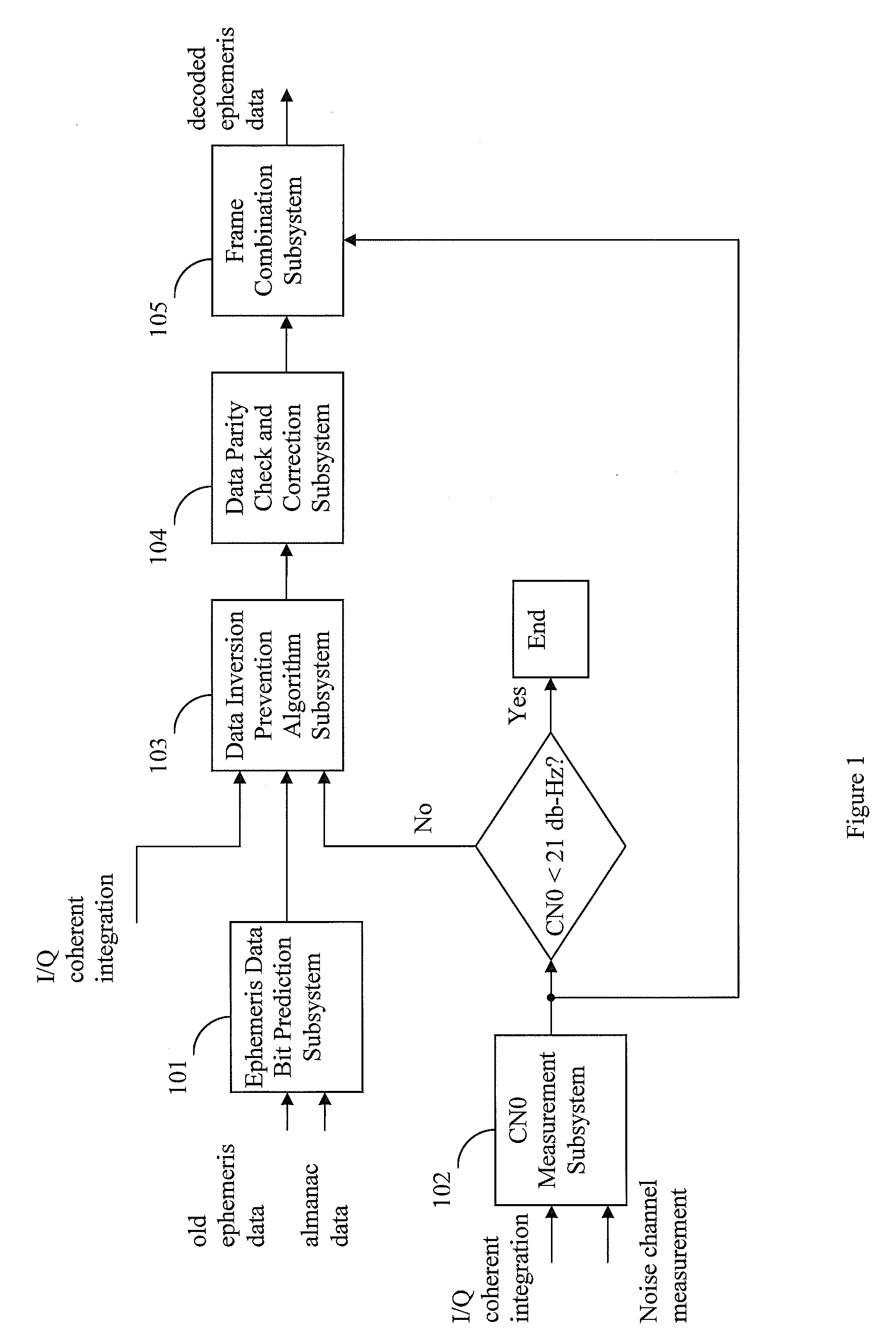
[0012]Systems and methods are disclosed herein to reliably demodulate and decode ephemeris data from a GPS satellite down to a CN0 of 23 dB-Hz. GPS data is organized into a GPS data frame of 50 words. Each data frame is further divided into 5 subframes of 10 words each. The GPS ephemeris data is encapsulated in 19 words of the 50 words data frame and consists of 3 words in subframe 1, 8 words in subframe 2, and 8 words in subframe 3. The ephemeris data is continuously transmitted by each satellite at the GPS data rate of 50 bits per second. Simulations with one or more embodiments of the present disclosure have shown a 95% probability of successfully decoding all bits in the 19 ephemeris data words of a GPS frame given two frames of data at a CN0 of 23 dB-Hz. It is assumed that the ephemeris data does not change for the two frames of data used for data decode. The probability of successful decoding can also be characterized in terms of word error rate (WER), detected word error rate...


PUM


Abstract

Systems and methods are disclosed herein for improving the sensitivity of satellite data decode in a satellite navigation receiver. The low signal ephemeris data decoding system of the present disclosure achieves a 5 db improvement in decoding sensitivity over conventional system by operating down to a CN0 of 21 dB-Hz. The improved sensitivity is achieved through a combination of reducing the number of data bits to be decoded, overcoming the inherent differential decoding problem of an all data bit polarity inversion, improving the probability of seeing single bit decoding error in an ephemeris word, running the parity correction algorithm, and reducing the undetected word error rate. The improved sensitivity makes it possible to predict the orbit of the satellite and to determine the receiver's location with higher accuracy even when operating in challenging signal conditions.

Description

TECHNICAL FIELD[0001]The present disclosure relates generally to a system and a method for improving the sensitivity of satellite data decode in a satellite navigation receiver. Specifically, the present disclosure relates to a system and a method to more reliably demodulate and decode GPS ephemeris data from a satellite in low satellite signal conditions down to a CN0 of 21 dB-Hz.BACKGROUND[0002]Satellite-based positioning systems include constellations of earth orbiting satellites that constantly transmit orbit information and ranging signals to receivers. An example of a satellite-based positioning system is the Global Positioning System (GPS), which includes constellations of earth orbiting satellites, also referred to as GPS satellites. The GPS satellites transmit precise orbit information and ranging signals which are received by GPS receivers. The GPS receiver receives the satellite signal information from three or more GPS satellites and calculates its location by measuring ...

Claims


Application Information

Patent Timeline
IPC IPC(8): G01S5/14
CPCG01S19/27G01S19/243
Inventor LENNEN, GARYKEAL, WILLIAM KERRY
Owner CSR TECH INC
Why Eureka
Try Eureka