Geosecurity methods and devices using geotags derived from noisy location data from multiple sources

a geotag and location data technology, applied in the field of geotag methods and systems, can solve the problems of limited stability or location accuracy, transmitters may be temporarily out of service, signals may experience unpredictable fluctuations, etc., and achieve the effect of increasing security, reducing false accept rate and geographic security radius

Inactive Publication Date: 2012-11-20
THE BOARD OF TRUSTEES OF THE LELAND STANFORD JUNIOR UNIV
View PDF6 Cites 33 Cited by
  • Summary
  • Abstract
  • Description
  • Claims
  • Application Information

AI Technical Summary

Benefits of technology

[0005]In one aspect, the present invention provides a method for geo-security implemented at a device that includes an RF receiver, computer processor and memory. The device receives RF communication signals transmitted from N multiple distinct classes of RF communication systems such as, for example, cellular communications, television communications, radio communications, terrestrial navigational, satellite navigational, satellite communication, wireless interne, bluetooth, and active RF identification systems. The use of multiple distinct signal sources helps reduce the false accept rate and geographic security radius. In some implementations, the device may cryptographically authenticate one or more of the RF communication signals to protect against RF signal spoofing. In addition, the device is preferably tamper-resistant to increase security.
[0007]The device computes a current geotag T′ from the signal parameters x′ and a public identifier P associated with a geo-secured function of the device. The geotag is computed by quantizing the N signal parameters x′ to produce N corresponding quantized signal parameters q′, computing a vector c′ from q′ and P, and computing the geotag T from c′ using Reed-Solomon decoding and a hash function. This method employs fuzzy extractors to provide a reproducible unique geotag and a low false rejection rate.

Problems solved by technology

This is a practical challenge, however, because geotags are customarily derived from radiofrequency (RF) signals that may not be reliable or may have limited stability or location accuracy.
For example, the signal transmitters may be temporarily out of service or the signals may experience unpredictable fluctuations due to noise or interference from environmental effects or other RF transmissions.
However, unpredictable fluctuations in the RF signals can potentially alter the location-dependent parameters, resulting in a different encrypted geotag for the same location.
Without the ability to reproduce unique geotags, valid locations will not be reliably authenticated (i.e., false rejection).
However, geotags with a larger geographical security radius will match a wider range of geographical positions, risking positive authentication at undesired locations (i.e., false acceptance).

Method used


Image

  • Geosecurity methods and devices using geotags derived from noisy location data from multiple sources
  • Geosecurity methods and devices using geotags derived from noisy location data from multiple sources
  • Geosecurity methods and devices using geotags derived from noisy location data from multiple sources

Examples


Embodiment Construction

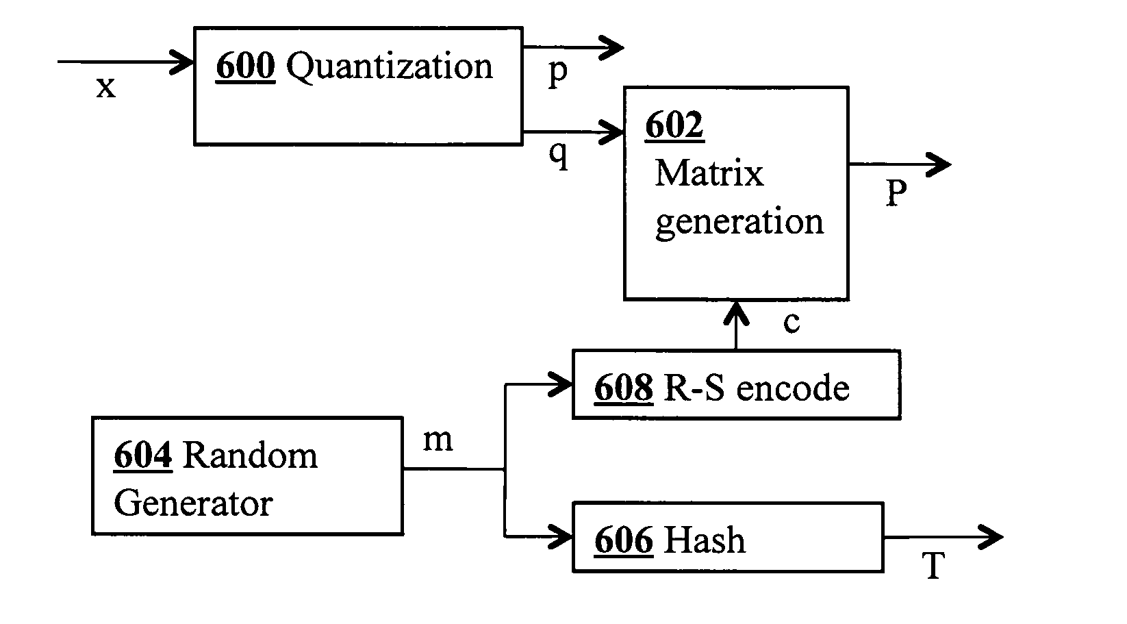
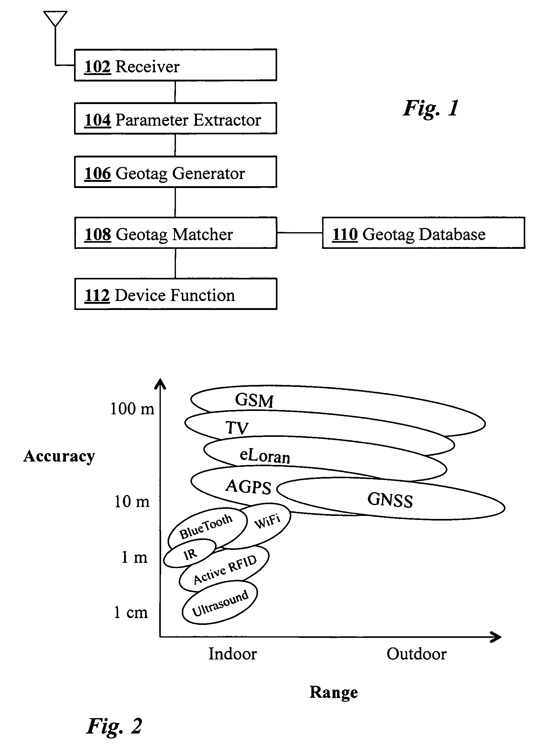
[0017]FIG. 1 is a block diagram illustrating components of a geosecurity device according to an embodiment of the present invention. RF signals from multiple sources are detected by an antenna 100 connected to a receiver 102 which is capable of receiving multiple distinct types of RF signals. Parameter extractor 104 connected to receiver 102 analyzes the received signals and extracts location-dependent signal parameters which are then passed to geotag generator 106. Using the extracted location-dependent parameters, geotag generator 106 computes an encrypted geotag which is then compared at geotag matcher 108 with one or more stored geotags in geotag database 110. Depending on the results of the match, a geosecured function 112 of the device may then be executed. The device is preferably tamper-resistant.

[0018]Although the term geotag is commonly used to describe any type of geographical metadata such as latitude and longitude associated with a piece of data such as a photograph, in...


PUM


Abstract

In a geo-security system, a device receives RF signals from multiple distinct classes of RF communication systems and extracts location-dependent signal parameters. A current geotag is computed from the parameters by fuzzy extractors involving quantization of the parameters and Reed-Solomon decoding to provide a reproducible unique geotag. The current geotag is compared with a stored geotag, and a geo-secured function of the device is executed based on the result of the comparison. The use of multiple signal sources of different types, combined with special fuzzy extractors provides a robust geotag that allows both lower false rejection rate and lower false acceptance rate.

Description

FIELD OF THE INVENTION[0001]This invention relates generally to cryptography and computer security. More specifically, it relates to methods and systems for geosecurity.BACKGROUND OF THE INVENTION[0002]Conventional security techniques are typically based on one or more factors such as something you know (e.g., a password), something you have (e.g., a key card), and something you are (e.g., biometrics). Geosecurity provides another factor: somewhere you are. More specifically, geosecurity involves the use of spatiotemporal information such as geographical position (and possibly time as well) as a factor in authentication. One application of geosecurity is to grant access to sensitive data only at authorized locations within a facility. Geosecurity techniques can also be used for a variety of other applications including generating alarms if a device is taken out of a secure area (i.e., geofencing), location-based control of device functionality (e.g., digital manners policy), proof o...

Claims


Application Information

Patent Timeline
Patent Type & Authority Patents(United States)
IPC IPC(8): H04K1/00
CPCG01S5/0252G08B21/0213G08B21/0269G08B21/0283H04W4/02H04L63/107H04W12/08G01S5/02523
Inventor QIU, DILO, SHERMANDE LORENZO, DAVID S.BONEH, DANENGE, PER
Owner THE BOARD OF TRUSTEES OF THE LELAND STANFORD JUNIOR UNIV
Why Eureka
Try Eureka