Civil construction engineering GPS-RTK measurement integrated PDA device

A GPS-RTK, civil construction technology, applied in measurement devices, radio wave measurement systems, special data processing applications, etc., can solve problems such as insufficient memory, no professional applications, no remote data transmission devices, etc., to improve work efficiency. and reliability, saving field work time, and expanding the scope of use

Inactive Publication Date: 2008-04-09
CHONGQING JIAOTONG UNIVERSITY
View PDF1 Cites 29 Cited by
  • Summary
  • Abstract
  • Description
  • Claims
  • Application Information

AI Technical Summary

Problems solved by technology

[0003] 1. The current products are all general-purpose industrial products without professional applications, mainly used for survey and construction in construction, electric power, machinery and other industries, and the operation efficiency is low
[0004] 2. The PDA computer is mainly used to calculate the current coordinates of the mobile station based on the collected GPS observation data, and only output the front-end data of the application, and cannot perform various real-time engineering application processing
[0005] 3. The PDA computers of the rover station of the existing GPS-RTK measurement system are all non-standard products, with large volume, small screen and no graphic display function. The computing speed of the processor is slow, and the memory is insufficient, so that the speed and efficiency of running applications are low
[0006] 4. The mobile station PDA computer operating system of the existing GPS-RTK measurement system is different, and the user's secondary development is very difficult
The built-in engineering professional application software has few functions, which makes engineering application processing very inconvenient
[0007] 5. Most of the mobile station PDA computers with existing GPS-RTK measurement systems are imported products, and the cost is relatively high, and the price is as high as tens of thousands of yuan
[0008] In addition, the "Altitude Measurement Equipment and Method Based on RTK-GPS Technology" disclosed by the Chinese patent CN1928586A discloses a method of measuring the latitude, longitude and altitude of the point to be measured, and outputting the device identification through model building, real-time processing and drawing results. real-time processing, and it cannot perform real-time processing

Method used


Image

  • Civil construction engineering GPS-RTK measurement integrated PDA device
  • Civil construction engineering GPS-RTK measurement integrated PDA device

Examples


Embodiment Construction

[0033] The present invention will be described in further detail below in conjunction with the accompanying drawings and specific embodiments.

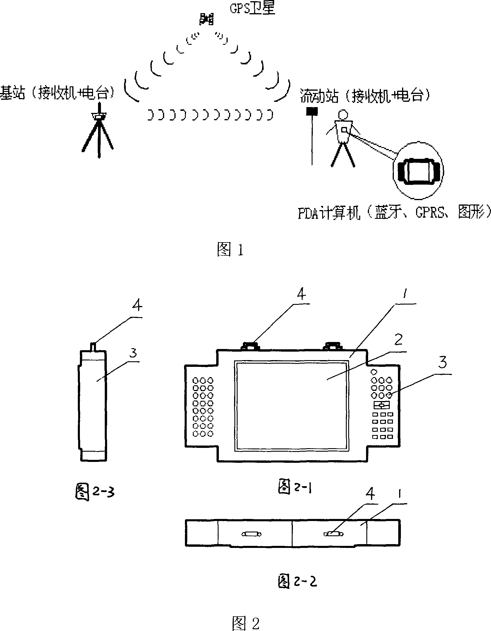
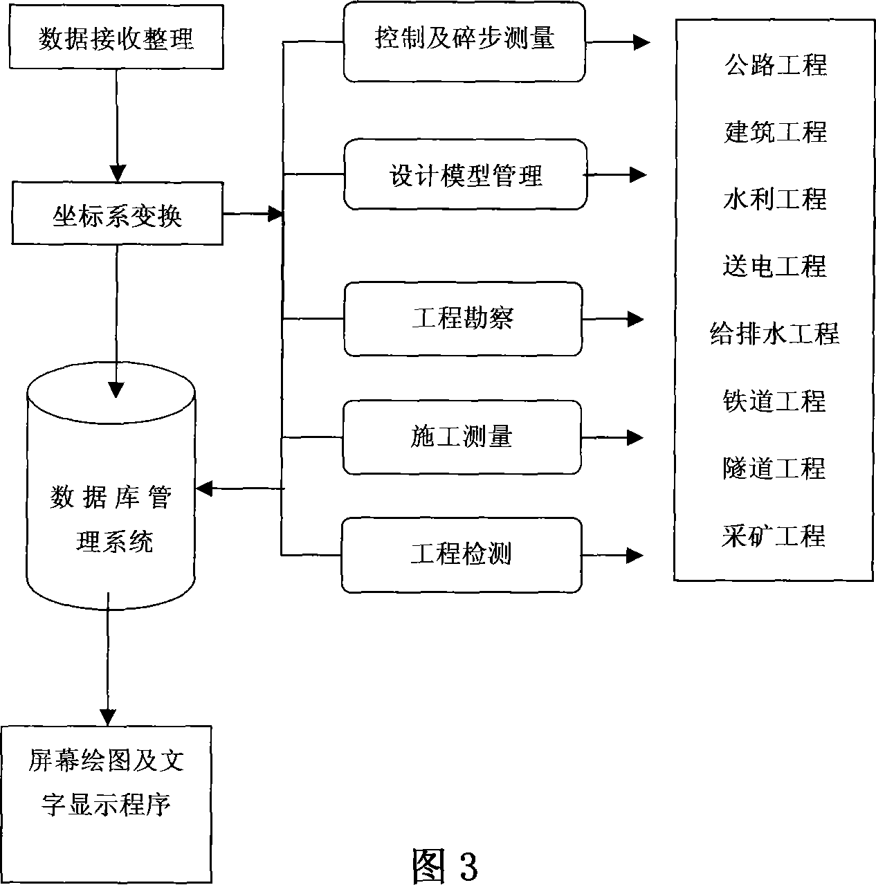
[0034] Referring to Fig. 1, civil construction engineering GPS-RTK surveys integrated PDA device of the present invention, comprises the PDA computer that is used for GPS-RTK data collection, processing and civil construction engineering application, combines with GPS-RTK data acquisition system to form mobile station, The GPS satellite data from the base station is received through the data link, together with the GPS satellite data of the rover, the integration of GPS differential observation data collection, processing, application and remote transmission of application data is completed simultaneously on the rover.

[0035] As shown in Fig. 2-1, Fig. 2-2 and Fig. 2-3, the GPS-RTK and PDA integrated device dedicated to civil engineering engineering of the present invention consists of a main body 1, a display screen 2, and two scree...


PUM


Abstract

The invention discloses a PDA device of civil and architectural engineering GPS-RTK measurement integration, which is a PDA computer used for GPS-RTK data collection and processing and applied to civil and architectural engineering. The hardware in the PDA computer comprises a display, press keys and hanging parts, a host chip equipped inside the body with a dominant frequency above 400MHz, a bluetooth module and a GPRS module, a built-in data transmission antenna and a power supply; a built-in software system in the PDA computer integrates the data collection, processing, application and transmission of GPS-RTK, which greatly enhances operation efficiency and reliability, directly accomplishes the tasks like design and survey, construction survey, and geometric detection etc. of normal civil engineering (including highways, railways, port terminals, city roads and pipe network, hydropower project and so on), does not need the prior fractional work such as data downloading, indoor processing, outdoor surveying and designing etc., and obviously enhances the operation efficiency of civil engineering measurement.

Description

technical field [0001] The invention relates to a field engineering surveying device, in particular to a GPS-RTK and PDA integrated system for civil and construction engineering. quality testing etc. Background technique [0002] In the prior art, a GPS-RTK (GPS-satellite navigation and positioning system, RTK-Real Time Kinematic, real-time dynamic) system used for field engineering surveys generally consists of a base station and multiple rover stations. Both the base station and the mobile station are composed of GPS main board, radio station, power supply, antenna and tripod, etc. The mobile station also includes a PDA (handheld computer) computer device. The base station transmits its observation value and station coordinate information to the mobile station through a data link. ; The rover receives the data from the base station through the data link, and calculates the observation data of GPS-RTK at the same time, and solves the current coordinates of the rover. The ...

Claims


Application Information

Patent Timeline
Patent Type & Authority Applications(China)
IPC IPC(8): G06F19/00G01S5/02G01B15/00G08C17/00
Inventor 冯晓
Owner CHONGQING JIAOTONG UNIVERSITY
Why Eureka
Try Eureka