Research method for dynamically monitoring slope scale erosion development process by utilizing three-dimensional laser scanning technique

A three-dimensional laser, dynamic monitoring technology, used in measuring devices, weighing equipment and instruments for materials with special properties/forms, etc., can solve the problems of photo data collection deviation, large projection deformation, uncertainty, etc. Fast and reliable results

Inactive Publication Date: 2010-08-04
郑粉莉 +2
View PDF1 Cites 21 Cited by
  • Summary
  • Abstract
  • Description
  • Claims
  • Application Information

AI Technical Summary

Problems solved by technology

However, due to the different adsorption capacity of soil for different trace elements, especially the limitation of the accuracy of the estimation equation and the inability to obtain a unique solution for the empirical equation, the estimation of slope soil erosion is uncertain.
Geometric photogrammetry technology has defects such as small measurement range, large projection deformation and overly sensitive response to ground slope, which greatly restricts the application of this technology in soil erosion
Laser micro-topographic scanning technology is only applicable to very small slope scales (less than 5m 2 ) soil erosion monitoring, and need to be measured under dark and light conditions, so its application is greatly limited
Large-scale aerial photogrammetry technology is to use orthophotography to take continuous large-scale aerial photos at high altitude, and then perform post-processing of the photos; Acquisition of aerial photography causes deviations, and the procedures for performing such aerial photography tasks are complicated, the cycle is long, the cost is high, and the economic benefit is poor; it is generally difficult for existing aerial photography professional units to undertake scattered small-area measurement, which limits Application of Photogrammetry Technology in Soil Erosion Monitoring
The high-precision GPS measurement method is affected by three parts: accuracy error, signal transmission error and receiver error, and its later image processing is greatly affected by the number of measurement points, especially in small-scale measurement errors on slopes, so it is not suitable for Dynamic Monitoring of Small-Scale Soil Erosion on Slope Surfaces

Method used


Image

  • Research method for dynamically monitoring slope scale erosion development process by utilizing three-dimensional laser scanning technique
  • Research method for dynamically monitoring slope scale erosion development process by utilizing three-dimensional laser scanning technique
  • Research method for dynamically monitoring slope scale erosion development process by utilizing three-dimensional laser scanning technique

Examples


example 1

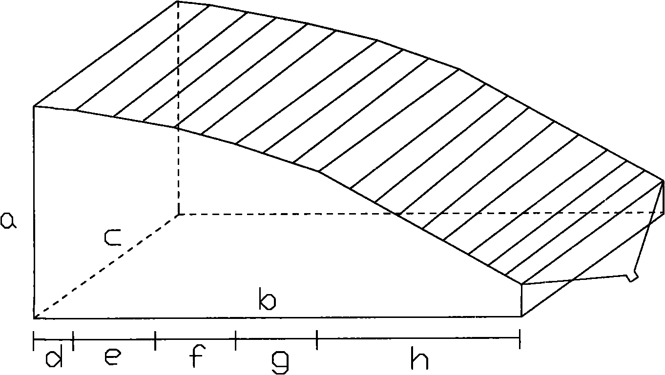
[0026] In this example, a solid model of the slope-gully system was constructed according to the spatial differentiation characteristics of the slope-gully system in the hilly-gully area of ​​the loess ( figure 1 ). The model height a: 6.01m, width c: 3m, length b: 13m, projection area 40m 2 ; and the solid model of the slope ditch system is divided into five slope sections from the top to the bottom of the slope according to the slope change of the typical slope ditch system in the loess hilly area, and the slope values ​​are 5° and 10° respectively , 15°, 20°, and 35° correspond to sections d, e, f, g, and h respectively, and the projected lengths of each section correspond to 1m, 2m, 2m, 2m, and 5m. A triangular collector is set under the generalized test model of the slope-groove system to collect the runoff and sediment yield of the solid model of the slope-groove system at any time during the rainfall process, so as to verify whether the three-dimensional laser scanning...


PUM


Abstract

The invention discloses a research method for dynamically monitoring a slope scale erosion development process by utilizing three-dimensional laser scanning technique, which has the advantages of quickness, accuracy, high precision and the special suitability for the dynamic monitoring of the slope scale soil erosion. The method comprises the following steps of: a, defining a measurement area, and measuring a soil density of the measurement area; gluing a circle of reflection material stickers on borders of the measurement area, scanning the area to be measured by using a three-dimensional laser scanning instrument so as to generate point cloud data of different parts of the measurement area; b, uniformly combining the scanning data of all sites to obtain the raw data; c, forming bright lines in the raw data by using the reflection materials on the borders of the measurement area, and cutting the measurement area; and d, vacuating the point cloud data generated after cutting, importing the point cloud data to the geological information system software, analyzing a volume change of the measurement area before and after rainfall, and according to the slope soil density and the volume variable quantity of the area to be measured, calculating the change of the individual rainfall soil erosion amount.

Description

Technical field: [0001] The invention relates to a research method for dynamic monitoring of soil erosion process, in particular to a research method for dynamic monitoring of slope scale erosion development process by using three-dimensional laser scanning technology. Background technique: [0002] Soil erosion has become one of the major ecological and environmental problems in the world, especially in my country. Soil erosion in my country not only has a large erosion area and a wide distribution range, but also has a large erosion intensity and serious erosion hazards, causing economic losses of more than 100 billion yuan per year. Serious soil erosion poses a serious threat to my country's food security and ecological security, and soil erosion has become the number one environmental problem in my country. Soil erosion intensity is an important index reflecting the degree of soil erosion hazard, ecological environment status and regional socio-economic development tren...

Claims


Application Information

Patent Timeline
Patent Type & Authority Applications(China)
IPC IPC(8): G01G17/04
Inventor 郑粉莉张鹏王彬
Owner 郑粉莉
Why Eureka
Try Eureka