Method for determining ecological dredging range of water body pollution bottom sediment

A technology for ecological dredging and determining methods, applied in special data processing applications, instruments, electrical digital data processing, etc., can solve problems such as no practical methods, lack of sediment pollution evaluation standards, etc., to achieve clear boundaries and clear dredging areas Effect

Inactive Publication Date: 2011-02-02
NANJING INST OF GEOGRAPHY & LIMNOLOGY
View PDF3 Cites 38 Cited by
  • Summary
  • Abstract
  • Description
  • Claims
  • Application Information

AI Technical Summary

Problems solved by technology

However, there are several obvious problems in this method: ① Lack of evaluation criteria for sediment pollution
Obviously, dredging for ecological and environmental protection has been implemente

Method used


Image

  • Method for determining ecological dredging range of water body pollution bottom sediment
  • Method for determining ecological dredging range of water body pollution bottom sediment
  • Method for determining ecological dredging range of water body pollution bottom sediment

Examples


Embodiment Construction

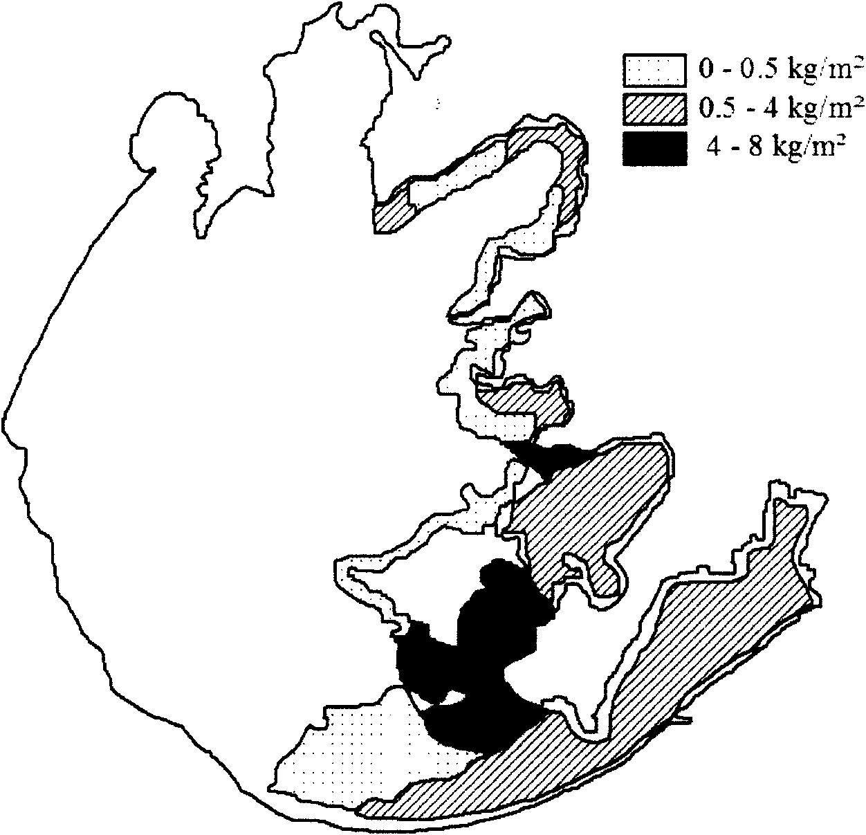
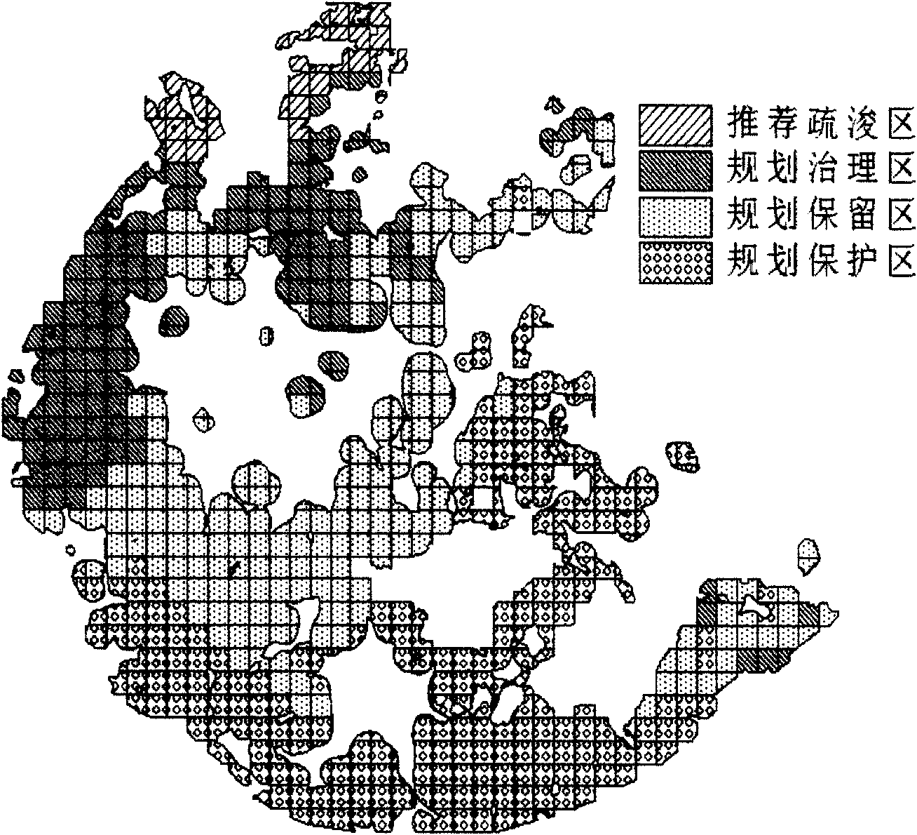
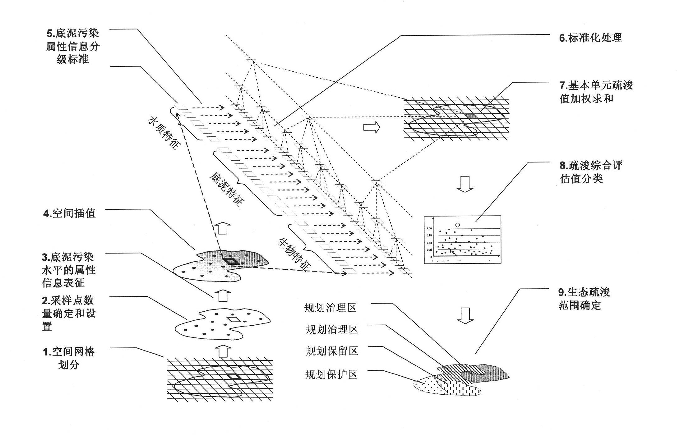
[0024] see figure 1 :

[0025] 1. Spatial grid

[0026] Spatial gridding refers to dividing grids of uniform size on the horizontal plane of the water body with reference to the latitude and longitude lines, and treating the water body and the bottom of the vertical projection of the plane grid as the same unit. The number of grids is determined according to the size of the water body. The layout of the grid adopts geographic information system (GIS) layout. Set the area at 50km 2 The above water body is defined as large, 50km 2 The following are small and medium. Considering meeting the basic requirements of data distribution evaluation in space and the quantity of attribute data, the number of water grids in this patent is not less than the number calculated by the following formula:

[0027]

[0028] where A is the water body area (km 2 ).

[0029] 2. Determination and setting of the number of sampling points

[0030] The number of sampling points is determined ...


PUM


Abstract

The invention discloses a method for determining ecological dredging range of water body pollution bottom sediment, comprising steps of: performing space gridding to a water area; setting a sampling point, and obtaining bottom sediment pollution level attribute information of the sampling point; determining the water area requiring dredging after excluding the water area without dredging; processing space interpolation to the bottom sediment attribute information of the water area to cover an unsampled water area with the attribute information, and obtaining the mean value of the single attribute information of the space interpolation in a grid cell, and grading the attribute, and rounding the attribute mean value of the grid cell hierarchically; performing dimensionless standardization treatment of 0-1 numerical values to the hierarchically rounded attribute information, and obtaining the evaluation coefficient of each attribute of the grid cell, summing the evaluation coefficients of all attributes of the grid cell to obtain a comprehensive evaluation value of the grid cell; classifying the comprehensive evaluation values of all grid cells by a natural breaking method of geographic information software and determining the recommended dredging area as the ecological dredging range with high comprehensive evaluation value.

Description

technical field [0001] The invention relates to water treatment and restoration technology, in particular to a method for determining the ecological dredging range of water body polluted sediment for the purpose of water quality improvement and ecological protection, which is applicable to inland surface polluted sediment of lakes, reservoirs and swamps. Background technique [0002] Dredging is the construction operation that removes bottom sediment or sediment from a body of water. When used in lakes for the purpose of water conservancy, it is to remove the silt accumulated at the mouth of the river, the protrusion of the lake bottom and the shore of the lake, so that the water in and out of the lake is unobstructed, the storage capacity is enlarged, and the water storage capacity is increased; for the purpose of port governance When the time comes, dig deep at the place where the boat is moored on the lake bank or dig wide and deep on the lake route. In addition, there i...

Claims


Application Information

Patent Timeline
IPC IPC(8): G06F19/00E02F5/28
Inventor 范成新陈爽
Owner NANJING INST OF GEOGRAPHY & LIMNOLOGY
Why Eureka
Try Eureka