
Computer emulation system for actual ground object imaging by space optical remote sensor

A space optical remote sensing and computer simulation technology, applied in computing, instrumentation, image data processing and other directions, can solve the problems of difficult to simulate the process of remote sensor imaging on the ground, difficult space optical remote sensor to image the ground, and the difficulty of further upgrading the platform, etc. To achieve the effect of compact structure, wide selection range and clear module

Active Publication Date: 2012-07-11
CHANGCHUN INST OF OPTICS FINE MECHANICS & PHYSICS CHINESE ACAD OF SCI
View PDF6 Cites 18 Cited by
  • Summary
  • Abstract
  • Description
  • Claims
  • Application Information

AI Technical Summary

Problems solved by technology

[0004] 1. Due to the limitation of the mechanical structure, the orbit and attitude parameters of the remote sensor simulated by the hardware simulation platform have a narrow range of variation. It is difficult to simulate the ground imaging of space optical remote sensors with various orbits and attitudes without modifying the mechanical structure design. , it is especially difficult to simulate the imaging process of the remote sensor on the elliptical orbit
[0005] 2. Due to the limitations of the processing accuracy of mechanical components and the synchronization accuracy of electronic components, the interference of errors such as synchronization mismatch and mechanical vibration of the hardware simulation platform on the simulation imaging is difficult to ignore and cannot be avoided
In addition, further upgrades to the platform are difficult

Method used


Image

  • Computer emulation system for actual ground object imaging by space optical remote sensor
  • Computer emulation system for actual ground object imaging by space optical remote sensor
  • Computer emulation system for actual ground object imaging by space optical remote sensor

Examples


Embodiment Construction

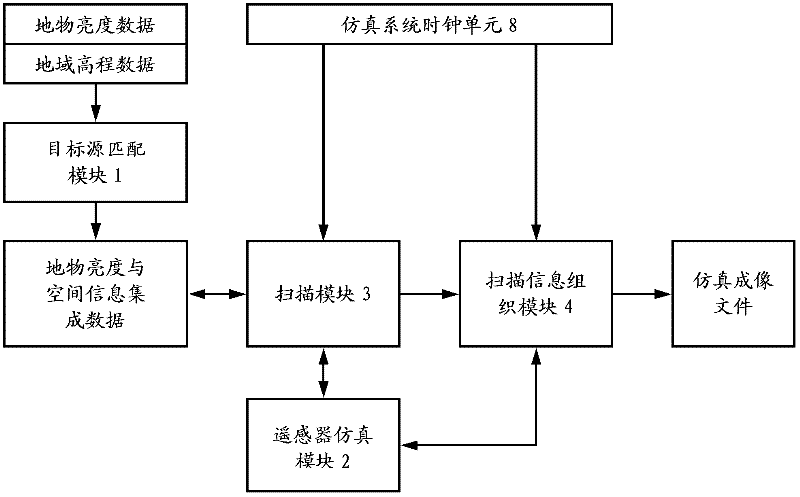
[0047] Such as figure 1 As shown, the computer simulation system of the present invention for space optical remote sensor imaging of actual ground features includes a target source matching module 1 , a remote sensor simulation module 2 , a scanning module 3 , a scanning information organization module 4 , and a simulation system clock unit 8 .

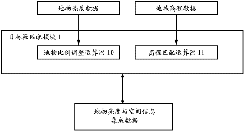
[0048] Such as figure 2 As shown, the target source matching module 1 includes a feature ratio adjustment calculator 10 and an elevation matching calculator 11 .

[0049] The target source matching module 1 takes ground object brightness data and regional elevation data as input. The format of the ground object brightness data is a two-dimensional plane image compatible with remote sensing, aerial photography or artificial simulation. The image follows the natural distance scale, and the numerical accuracy of the image brightness matrix In terms of image spectrum, it can be a grayscale bitmap or a floating-point matrix; in terms of ...


PUM


Abstract

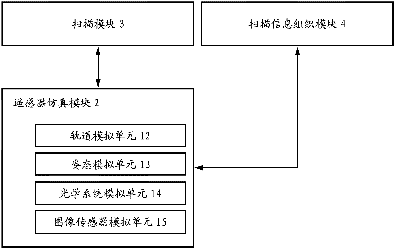
The invention relates to a computer emulation system for actual ground object imaging by a space optical remote sensor. A target source matching module of the system is used for supplying ground object brightness and space information integrating data to a scanning module; a remote scanner emulation module is used for supplying remote sensor track parameters, posture parameters, optical system focal distances, point spread functions of all sub-fields of an optical system and physical parameters of an image sensor to the scanning module and a scanning information organization module; a clock unit of the emulation system is used for supplying time synchronization information to the scanning information organization module; the scanning module is used for receiving an image coordinate gray level time sequence of each image element according to the received information and supplying the image coordinate gray level time sequence to the scanning information organization module; and the scanning information organization module is used for obtaining a brightness matrix of a ground imaging emulation image according to the received information. According to the computer emulation system for the actual ground object imaging by the space optical remote sensor, provided by the invention, the ground imaging process can be emulated by the space optical remote sensor with any posture on any track; and the computer emulation system is compact in structure and is easy to update according to actual scientific research requirements.

Description

technical field [0001] The invention relates to a computer simulation system for assisting optical performance detection of space optical remote sensors in the field of space applications, especially capable of imaging ground objects with three-dimensional terrain fluctuations by push-broom or staring space optical remote sensors in various space attitudes A system for simulating the process. Background technique [0002] The ground imaging simulation of space optical remote sensor is an important link in the design and manufacture of space optical remote sensor. At present, the simulation of the ground imaging process of the space optical remote sensor mainly adopts hardware means: calculate the relative motion relationship between the space optical remote sensor and the ground target according to the earth's rotation and the motion state of the remote sensor in orbit, and according to the motion relationship, Use rollers, three-axis air-floor platforms, or rotating arms t...

Claims


Application Information

Patent Timeline
IPC IPC(8): G06T17/05
Inventor 孙阳闫锋薛栋林郑立功张学军
Owner CHANGCHUN INST OF OPTICS FINE MECHANICS & PHYSICS CHINESE ACAD OF SCI
Learn More