Three-dimensional optimizing route selection method based on airborne laser radar

A technology of airborne laser radar and line selection method, which is applied in the direction of electromagnetic wave re-radiation, radio wave measurement system, utilization of re-radiation, etc. and other problems, to achieve the effect of improving the efficiency of optimized line selection, high ground sampling density, and reduced field workload

Inactive Publication Date: 2012-09-12
MIANYANG SKYEYE LASER TECH
View PDF1 Cites 79 Cited by
  • Summary
  • Abstract
  • Description
  • Claims
  • Application Information

AI Technical Summary

Problems solved by technology

Although the optimal line selection technology based on satellite imagery and aerial photogrammetry has a history of nearly ten years, this technology has the following inevitable shortcomings: a. Poor adaptability to meteorological conditions in the field of aviation
The 3D scene based on the aerial photogrammetry method can only be seen with the help of special equipment. The operator needs to wear a stereoscope to optimize the line selection in the 3D scene. Moving left and right is prone to image misalignment

Method used


Image

  • Three-dimensional optimizing route selection method based on airborne laser radar
  • Three-dimensional optimizing route selection method based on airborne laser radar

Examples


Embodiment Construction

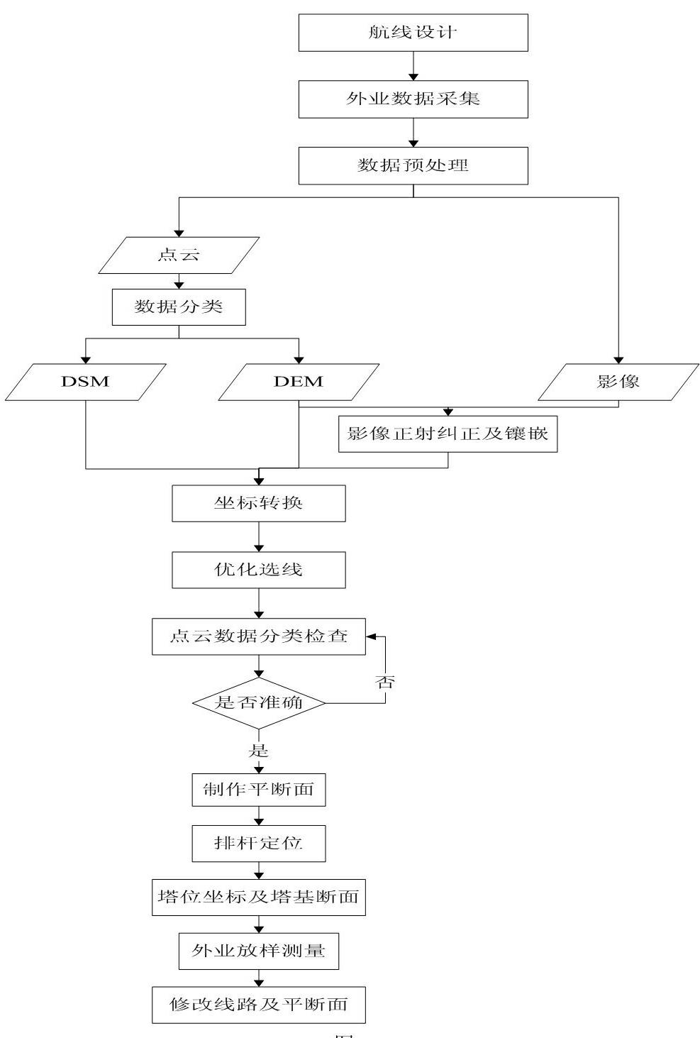
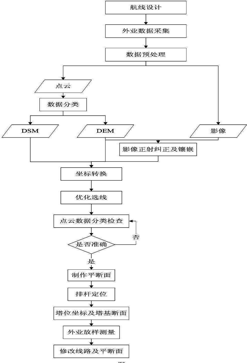
[0016] Taking the Danba-Xiaojin 220kV overhead transmission line project as an example, according to figure 1 The workflow shown is detailed below:

[0017] Step 1: Airborne lidar flight design

[0018] 1. According to the preliminary design route plan, use the 1:10000 topographic map to design the flight route;

[0019] 2. Coordinate system design. Adopt the 1954 Beijing coordinate system, Gaussian projection, 3-degree zone, and the longitude of the central meridian is 102°. The elevation datum adopts the 1956 Yellow Sea elevation;

[0020] 3. DEM and DOM precision design. DEM and DOM results must meet the 1:1000 scale accuracy requirements;

[0021] 4. Instrument parameter design. According to the accuracy requirements of DEM and DOM, design parameters such as ground laser point interval, scanning angle, camera exposure speed, camera lens focal length, point cloud flight belt overlap, image heading and side overlap, flight speed, and flight height;

[0022] 5. Accordi...


PUM


Abstract

The invention discloses a three-dimensional optimizing route selection method based on an airborne laser radar. The method comprises the following steps of: carrying out flight design according to a feasible route of a line, and acquiring flight field data by the laser radar according to design parameters; carrying out united computation on laser ranging data and POS system positioning data to obtain laser point cloud data through pre-processing the data; post-processing the data to obtain a point cloud classification map, a digital elevation model (DEM), a digital surface model (DSM), a contour line and a digital orthoimage map (DOM); importing into a three-dimensional optimizing route selection system, selecting a line route, checking peripheral landform of a line corridor, and carrying out optimization design on the line; combining with a three-dimensional image and a plane section, carrying out operations of pre-arranging poles and arranging poles in a route selection software, and outputting an image route diagram; and drawing the plane section of the route, and carrying out alignment survey. The method utilizes the section view and the orthoimage in the three-dimensional optimizing route selection system to realize the operations of pre-arranging the poles and arranging the poles, so as to generate a plane section diagram needed by power industry department, and the operation efficiency of route selection is improved.

Description

technical field [0001] The invention belongs to the technical field of line selection for overhead power transmission lines, and in particular relates to a three-dimensional line optimization design method based on an airborne laser radar. Background technique [0002] At present, domestic overhead high-voltage transmission line optimization and selection projects are usually realized by a combination of satellite images and aerial photogrammetry, that is, large-scale comparisons are made based on satellite images or other small-scale topographic maps, and the recommended route plan is determined. The aerial photogrammetry method obtains the aerial image pair with a width range of 2km~3km along the route, and uses the digital photogrammetry workstation to carry out aerial triangulation encryption measurement by arranging image control points, and restores the three-dimensional model of the image pair, so as to construct the three-dimensional scene of the line corridor. On th...

Claims


Application Information

Patent Timeline
Patent Type & Authority Applications(China)
IPC IPC(8): G01S17/89
Inventor 唐丹窦延娟潘文武王欣范应全董斌
Owner MIANYANG SKYEYE LASER TECH
Why Eureka
Try Eureka