Method and system for acquiring three-dimensional building information rapidly

A building information, 3D technology, applied in the field of fast acquisition of LiDAR point cloud data and DLG data integration of 3D building information, can solve the problems of long processing time, reliability and accuracy cannot be effectively guaranteed, and a large amount of processing, to achieve accurate location information , Realize the effect of automation and speed

Inactive Publication Date: 2012-10-03
CHINA UNIV OF GEOSCIENCES (BEIJING)
View PDF4 Cites 26 Cited by
  • Summary
  • Abstract
  • Description
  • Claims
  • Application Information

AI Technical Summary

Problems solved by technology

[0004] The method of manual extraction is to read the information of each building from the image or the field according to human interpretation. Since the extraction is completely based on human experience and methods, the speed is slow and consumes a lot of manpower and material resources
[0005] The method of aerial photography mainly uses stereo image pairs to reconstruct the 3D model of buildings through feature matching and collinear conditional equations. The matching algorithm directly determines the correctness and integrity of the results. The shadow calculates the height of the building and establishes a 3D digital model of the building, but usually it can only be applied to buildings with regular geometry, and the reliability and accuracy cannot be effectively guaranteed
[0006] The method of using laser scanning to establish a 3D model of a building is a newly developed technology. The main method is to use an airborne or ground 3D laser scanner to construct a laser point cloud to establish a 3D model of a building. This method has high accuracy, but A large amount of point cloud data needs to be processed, the workload is heavy, the process is complicated, and the processing time is long. However, in the application, we do not need such high precision to obtain the 3D model of the building
[0007] In addition, there is currently a way to obtain a 3D model of a building by combining aerial image data and laser scanning data, mainly using high-resolution aerial images to obtain building plane outline information, and using laser scanning data to obtain height information. The method of obtaining the outline of buildings from aerial images requires the use of corresponding algorithms to extract building outlines, and it is only suitable for buildings with regular outlines, and there are still many building outlines that cannot be effectively extracted

Method used


Image

  • Method and system for acquiring three-dimensional building information rapidly
  • Method and system for acquiring three-dimensional building information rapidly
  • Method and system for acquiring three-dimensional building information rapidly

Examples


Embodiment Construction

[0049] In order to make the technical problems, technical solutions and beneficial effects solved by the present invention clearer, the present invention will be further described in detail below in conjunction with the accompanying drawings and embodiments. It should be understood that the specific embodiments described here are intended to explain the present invention, but not to limit the present invention.

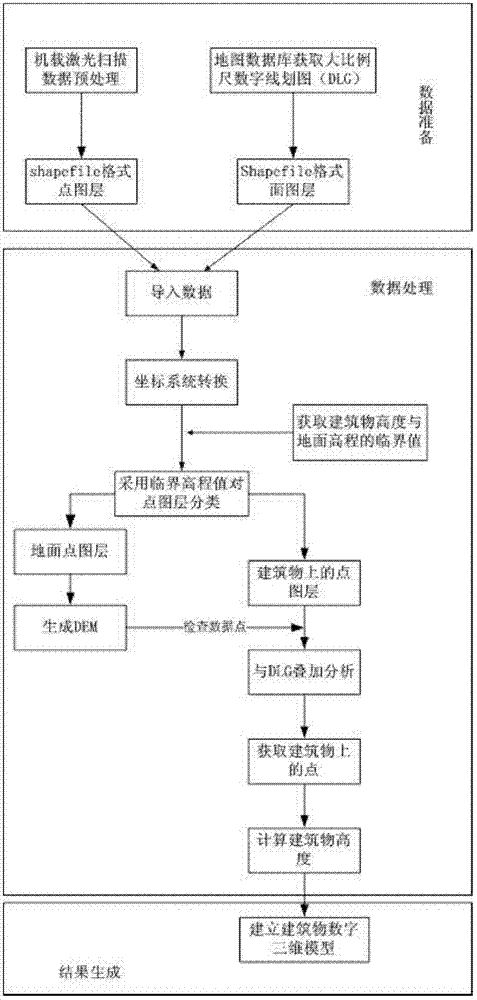
[0050] Such as figure 1 The overall technical flow chart of the present invention shown, the main content includes: data preparation, data processing and result generation are composed of three parts, and its specific implementation method includes the following steps:

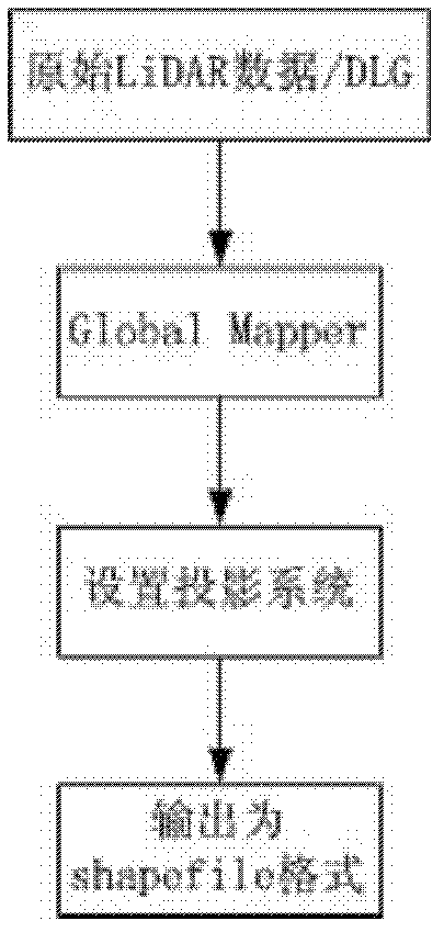
[0051] Step S101, raw data preprocessing. The raw data include LiDAR point cloud data (*.1as format) and large-scale DLG data of the study area obtained from the map database. The preprocessing of raw data includes using Global Mapper software to convert the LiDAR point cloud data in las format into...


PUM


Abstract

The invention discloses a method and system for acquiring the three-dimensional building information rapidly. The method comprises the following steps: preparing data, processing data and generating data. The method comprises the following specific steps: (1) preprocessing the original data; (2) acquiring the critical elevation value; (3) guiding the data into service processing software; (4) converting a coordinate system; (5) classifying the point layer data; (6) establishing a digital terrain model and acquiring a terrain continuously-varying interval; (7) checking and extracting points on buildings; (8) calculating the height of the buildings; and (9) establishing and displaying the digital three-dimensional models of the buildings. A method for constructing a digital city rapidly according to the buildings in a set area is designed by using the system integrating mode, and the three-dimensional models of the city buildings can be established and displayed rapidly. The method can be applied to the fields of land utilization condition survey, the digital city construction and the like. The method and the system can be used for acquiring the three-dimensional building information rapidly and effectively at low cost.

Description

technical field [0001] The present invention relates to the technical field of acquiring three-dimensional building information, in particular to a method and system for rapidly acquiring LiDAR (Light Detection And Ranging, laser radar) point cloud data and DLG (Digital Line Graphic, digital line drawing) data and integrating three-dimensional building information . Background technique [0002] With the accelerated development of industrialization and urbanization, the hysteresis of urban information has become an urgent problem to be solved in today's development. How to quickly, effectively and cheaply obtain urban building information and establish a digital city is a common concern of urban managers today. question. In addition, building information acquisition is also a very important aspect in the evaluation of intensive land conservation and utilization in urban and village areas, and rapid acquisition of urban building information is also a crucial technical suppor...

Claims


Application Information

Patent Timeline
Patent Type & Authority Applications(China)
IPC IPC(8): G06T17/00
Inventor 郑新奇艾刚孙义博贾宗仁王鹤饶
Owner CHINA UNIV OF GEOSCIENCES (BEIJING)
Why Eureka
Try Eureka