
System and method for processing unmanned aerial vehicle polling image

An image processing and unmanned aerial vehicle technology, applied in the direction of three-dimensional position/channel control, etc., can solve problems such as difficult to achieve fast and effective identification, unable to determine the position and number of transmission line equipment, and unable to accurately record the trajectory

Active Publication Date: 2014-07-23
STATE GRID INTELLIGENCE TECH CO LTD
View PDF11 Cites 134 Cited by
  • Summary
  • Abstract
  • Description
  • Claims
  • Application Information

AI Technical Summary

Problems solved by technology

[0005] First, because the positioning accuracy of the GPS position is about 10 meters, the positioning accuracy is poor, and the trajectory cannot be accurately recorded, and the precise position coordinates of the drone when the image is taken cannot be obtained, and the positioning accuracy is difficult to meet the requirements;
[0006] Second, since the identification and matching of the transmission line equipment in the image captured by the airborne imaging module is not only related to the position coordinates of the UAV, but also related to the movement angle of the gimbal equipped with the imaging module, the existing UAV inspection Image position positioning only through position coordinates, it is difficult to meet the technical requirements of UAV inspection in terms of accuracy and reliability;
[0007] Third, the identification speed of transmission line equipment in existing inspection images is slow, the accuracy of identification of transmission line equipment is low, and the time complexity of identification is high, making it difficult to achieve fast and effective identification;
[0008] Chinese Invention Patent Application No. "200910100170.6" for "Rapid Image Recognition Method of Insulator Outline" and Chinese Invention Patent Application No. "200910100169.3" for "Rapid Image Recognition Method for Power Line Outline", and Chinese Invention Patent Application No. "201310218102.6" The patent of "Image Recognition Method for Intelligent Line Inspection of Transmission Lines" all uses image recognition algorithms to identify the type or defect of the transmission line equipment in the image, but the position and number of the transmission line equipment in the image cannot be determined
[0009] The Chinese invention patent application number is "201210037780.87", the patent of "UAV aerial photography measurement method and UAV aerial photography measurement system", which determines the position of the UAV by recording the GPS position at the moment of image exposure, but this method cannot Determining the location of transmission line equipment in UAV inspection images
The above patents or papers are all about image acquisition technical devices or systems, which are at the level of theoretical research and cannot be applied to the field of UAV transmission line inspection.
[0010] To sum up, the existing UAV inspection image processing system and method applied to UAV transmission line inspection, the effect is not ideal, and there are still many problems to be solved

Method used


Image

  • System and method for processing unmanned aerial vehicle polling image
  • System and method for processing unmanned aerial vehicle polling image
  • System and method for processing unmanned aerial vehicle polling image

Examples


Embodiment Construction

[0129] The present invention will be further described below in conjunction with the accompanying drawings and embodiments.

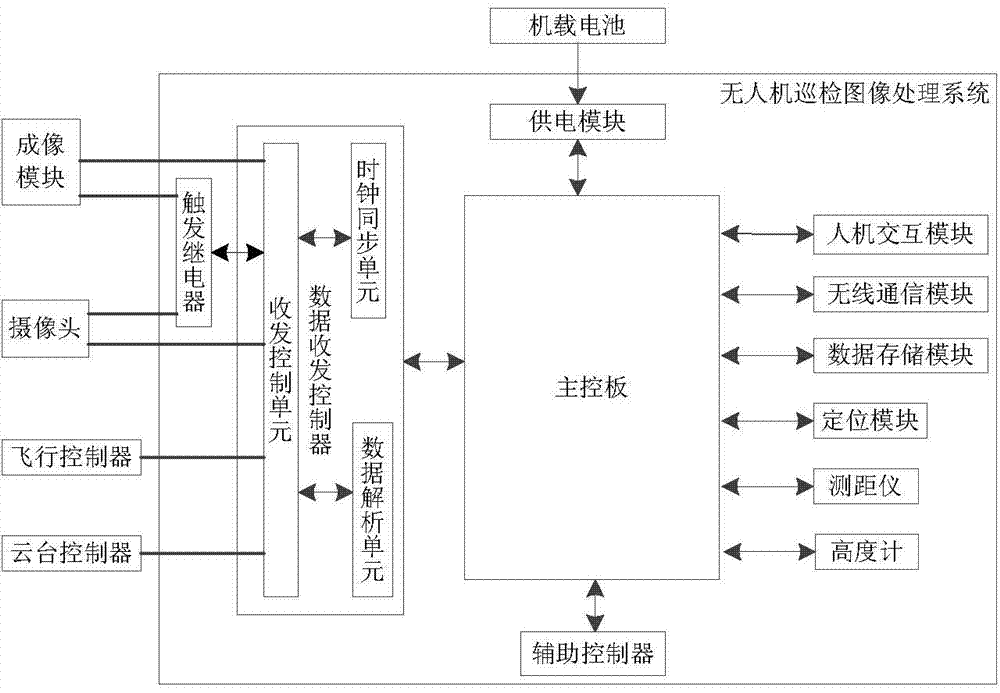
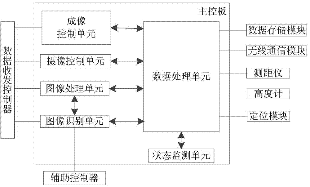
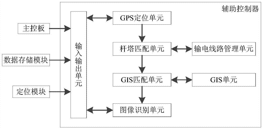
[0130] Such as figure 1 As shown, the UAV inspection image processing system includes a main control board, the main control board and a data transceiver controller, an auxiliary controller, a power supply module, a human-computer interaction module, a wireless communication module, a data storage module, and a positioning module , the rangefinder and the altimeter communicate, and the power supply module is connected with the onboard battery; the data transceiver controller includes a transceiver control unit, and the transceiver control unit communicates with a clock synchronization unit and a data analysis unit respectively, and the transceiver control unit The unit also communicates with peripheral equipment, and the peripheral equipment includes an imaging module, a camera, a flight controller and a gimbal controller, and the transceiver control un...


PUM


Abstract

The invention discloses a system and method for processing an unmanned aerial vehicle polling image. The system comprises an unmanned aerial vehicle polling image processing system body which comprises a human-computer interaction module. After the human-computer interaction module obtains a user instruction, a main control panel analyzes the user instruction and transmits the analyzed instruction to a data receiving and transmitting controller, the data receiving and transmitting controller sends a parameter configuration instruction to corresponding peripheral equipment according to the instruction and transmits an instruction execution result back to the main control panel, and the main control panel processes the execution result of the parameter configuration instruction and then sends processed information to the human-computer interaction module so that the information can be displayed to a user. The main control panel is respectively communicated with a secondary controller, a power supply module, a wireless communication module, a data storage module, a locating module, a distance measuring meter and a height gauge. The system and the method improve the automation degree and the informationization degree of polling image processing, improve the efficiency of searching for and processing the polling result, and lower the cost of processing the polling result.

Description

technical field [0001] The invention belongs to the field of operation and maintenance of power systems, and relates to the fields of unmanned aerial vehicle transmission line inspection, electronic information engineering, image recognition and the like, in particular to a UAV inspection image processing system and method. Background technique [0002] UAV line inspection is playing an increasingly important role in transmission line inspection, which can greatly reduce the workload of power service personnel, reduce the probability of possible personnel danger, reduce the maintenance cost of power equipment, and improve the safety of the power grid sex and reliability. [0003] In the process of UAV inspection, the processing of inspection results is the core work of UAV inspection. How to determine the location and type of transmission line equipment in the inspection image is the key to improving the efficiency of inspection results processing. During the UAV inspectio...

Claims


Application Information

Patent Timeline
IPC IPC(8): G05D1/10
Inventor 张明江王万国王滨海刘俍张方正董罡慕世友任杰傅孟潮郑天茹张晶晶魏传虎
Owner STATE GRID INTELLIGENCE TECH CO LTD
Learn More