Method for quickly measuring topography by using ground laser scanner based on CORS (Continuous Operational Reference System) and ICP (Iterative Closest Point) algorithms

A laser scanner and scanner technology, which is used in measurement devices, cross-section drawing, instruments, etc., can solve the problems of low operation efficiency of ground laser scanners, increased time consumption, and influence on the popularization and application of ground laser scanners.

Active Publication Date: 2014-10-01
GUANGZHOU URBAN PLANNING & DESIGN SURVEY RES INST
View PDF8 Cites 37 Cited by
  • Summary
  • Abstract
  • Description
  • Claims
  • Application Information

AI Technical Summary

Problems solved by technology

[0006] (3) Centering and leveling: Some scanner operations require centering and leveling, which increases the time spent on each station by 2 minutes
[0008] The above reasons lead to low operating efficiency of ground laser scanners, and the accuracy of point clouds after splicing cannot be guaranteed, which affects the popularization and application of ground laser scanners in topographic surveying, engineering surveying and other fields.
The patent case with the Chinese patent announcement number CN102393183A discloses a ground laser scanner scanning operation and splicing conversion method based on the control net

Method used


Image

  • Method for quickly measuring topography by using ground laser scanner based on CORS (Continuous Operational Reference System) and ICP (Iterative Closest Point) algorithms
  • Method for quickly measuring topography by using ground laser scanner based on CORS (Continuous Operational Reference System) and ICP (Iterative Closest Point) algorithms
  • Method for quickly measuring topography by using ground laser scanner based on CORS (Continuous Operational Reference System) and ICP (Iterative Closest Point) algorithms

Examples


Embodiment Construction

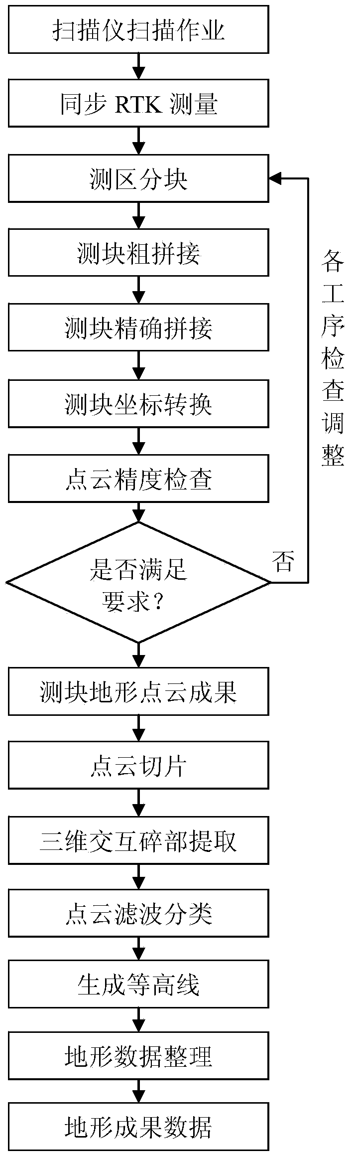
[0061] The present invention will be further described below in conjunction with the accompanying drawings of the specification.

[0062] Such as figure 1 As shown, a ground laser scanner based on CORS and ICP algorithm to quickly measure terrain includes the following steps:

[0063] Step 1: Use RieGL VZ400 ground laser scanner, the scanner comes with an external camera, and the connection device makes the GPS antenna and the scanner (including the camera) coaxially connected; after connection, ensure that the centering deviation of the two instruments is in mm level, because The height difference between the centers of the two instruments is small (usually about 20cm). The horizontal projection deviation of the center of the two instruments caused by the tilt within 5 degrees is less than 2cm, and the height deviation is less than 1cm, then the scanning is not strictly leveled (inclination of 5 degrees). The accuracy has little effect.

[0064] Step 2: Use a small car as a carrie...


PUM


Abstract

The invention discloses a method for quickly measuring topography by using a ground laser scanner based on CORS (Continuous Operational Reference System) and ICP (Iterative Closest Point) algorithms. The method comprises the following steps: 1, coaxially connecting a GPS (Global Position System) antenna with the scanner; 2, mounting the scanner at the top of a vehicle; 3, scanning in 360 degrees through the scanner during operating; 4, synchronously measuring a topocentric geodetic coordinate of the scanner by using a GPS carrier phase dynamic real-time difference method on the basis of CORS; 5, partitioning large measuring regions into blocks along roads and rivers; 6, roughly registering measurement blocks by using public planimetric points between measuring stations; 7, carrying out multi-station cloud accurate splicing in the measurement blocks by using an iterative closest point algorithm from a point to a tangent plane; 8, converting point cloud of the measurement blocks to the geodetic coordinate by using the topocentric geodetic coordinate; 9, dividing a three-dimensional point cloud into ground points and non-ground points and generating a contour line by using the ground points; 10, measuring and drawing a terrain landform line graph by using a method of collecting man-machine interaction details and slicing point cloud based on the three-dimensional point cloud; and 11, carrying out field investigation and plotting, mending and measuring, and editing and finishing a terrain line graph to obtain a topography result.

Description

Technical field [0001] The invention relates to the fields of surveying and mapping science and technology, computer graphics and vision technology, in particular to a method for quickly measuring terrain with a ground three-dimensional laser scanner based on CORS and ICP algorithms. Background technique [0002] At present, large-scale topographic surveying is still a full-field digital surveying mode dominated by total station acquisition details, and topographic surveying by ground laser scanners (hereinafter referred to as scanners) is still in the research stage. Scanner is a high-tech in the field of surveying and mapping. The acquired data is composed of point clouds and images. It not only records the coordinate data and size information of the terrain, but also automatically records its topology information and texture information. Compared with traditional measurement methods, ground-based laser scanners have the characteristics of not requiring sighting department, aut...

Claims


Application Information

Patent Timeline
IPC IPC(8): G01C7/04
CPCG01C7/04
Inventor 王峰林鸿李长辉黎树禧刘业光陈焕然罗峰秦红艳
Owner GUANGZHOU URBAN PLANNING & DESIGN SURVEY RES INST
Why Eureka
Try Eureka