A ground-penetrating radar-based method for spatial prediction of underground structure in red soil critical zone

An underground structure and ground penetrating radar technology, applied in the field of metrological soil science, can solve the problems of lack of key zone structure, thickness inversion, hindering work, limited data, etc., and achieve superior rain and heat conditions, rapid economic development, and intensive farmland. high degree of effect

Active Publication Date: 2020-04-24
INST OF SOIL SCI CHINESE ACAD OF SCI
View PDF7 Cites 0 Cited by
  • Summary
  • Abstract
  • Description
  • Claims
  • Application Information

AI Technical Summary

Problems solved by technology

Through a large number of geological drilling, relevant information on the underground structure of the red soil critical zone in this watershed has been obtained, but the information on the underground structure of the red soil area at the municipal, provincial and other regions is still relatively scarce
[0008] (2) The definition of the structure and thickness of the critical zone of red soil is not clear enough, and there is a lack of uniform standards
[0009] (3) Computer physics problems
The high cost of drilling leads to very limited data acquisition and the high spatial variability of the critical zone structure, leading to high uncertainty in the predictive model
Existing 3D soil mapping methods pay more attention to soil prediction at a depth of one meter, and pay less attention to the vertical dimension variation characteristics of physical and chemical properties of different regolith layers in critical zones
[0010] (4) Existing econometric soil science technology pays more attention to two-dimensional mapping or three-dimensional mapping of shallow soil (1-2m) dominated by plant root growth layer, and lacks the structure and thickness inversion of critical zones combined with geophysical exploration methods. The relevant technical system for expressing the spatial structure of the critical zone has not been comprehensively and systematically developed, especially the irregular three-dimensional space simulation and expression for the underground critical zone
[0011] The above-mentioned technical defects have seriously affected the efficient acquisition of underground structure information in the red soil area, and have directly hindered the related work of different industry departments, reduced the efficiency and accuracy of production and processing of soil information products, and indirectly brought new problems to national economic planning and regulation. potential loss

Method used


Image

  • A ground-penetrating radar-based method for spatial prediction of underground structure in red soil critical zone
  • A ground-penetrating radar-based method for spatial prediction of underground structure in red soil critical zone
  • A ground-penetrating radar-based method for spatial prediction of underground structure in red soil critical zone

Examples


Embodiment Construction

[0070] The specific implementation manners of the present invention will be further described in detail below in conjunction with the accompanying drawings.

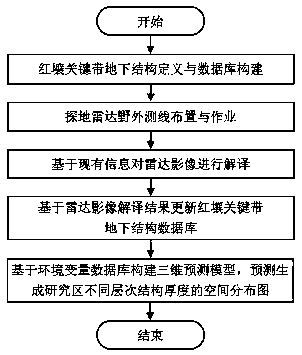
[0071] like figure 1 As shown, the present invention has designed a kind of ground-penetrating radar-based method for predicting the underground structure space of the red soil critical zone, which is applied in practice, and specifically includes the following steps:

[0072] Step A. Construct the underground structure database of the target red soil critical zone according to the preset data structure type, and then proceed to step B.

[0073] The genetic types of Quaternary red soil in southern my country include sedimentary type and weathered residual type. The former can be divided into slope accretion, alluvial, eolian and other types according to different sedimentary facies. Residual laterite is the most common type of laterite in the southern laterite area, mainly including granite, red sand shale, limestone ...


PUM


Abstract

The invention relates to a method of spatial prediction for underground structures of key red-soil zones based on a ground penetrating radar, which includes Step A, to construct a database of underground structure of target key red-soil zones; Step B, to measure target key red-soil zones and obtain radar image data of target key red-soil zones; Step C, to interpret radar images of target key red-soil zones and obtain radar image interpretation results; Step D, to update the database of the underground structure of the target red soil key zones; Step E, to construct a three-dimensional prediction model of the underground structure of the target red soil key zones, and to obtain the spatial distribution of different layers of the underground structure of the target red soil key zones. The designing method can not only give a key zone's detailed structure definition, database construction and ground penetrating radar operation process, but also quantify the spatial coupling relationship between the thickness / type of a key zone structure and environmental variables.

Description

technical field [0001] The invention relates to a ground-penetrating radar-based method for predicting the underground structure space of a red soil critical zone, and belongs to the technical field of soil measurement. Background technique [0002] The Earth’s critical zone is the area where the soil, atmosphere, biosphere, hydrosphere, and lithosphere material migration and energy intersect in the Earth’s surface system. In the vertical direction, it includes the area from the vegetation canopy to the underground aquifer. It is the area for human survival and development. core area. The formation of soil has experienced the weathering process of bedrock: unweathered→slightly weathered→moderately weathered→strongly weathered→residual soil. Broadly speaking, the unweathered bedrock layer is defined as the lower boundary of the critical zone, which is the depth from the surface to the unweathered bedrock. This thickness is of great significance to regional and even global a...

Claims


Application Information

Patent Timeline
Patent Type & Authority Patents(China)
IPC IPC(8): G01V3/12G01S13/89
CPCG01S13/89G01V3/12
Inventor 宋效东朱俊吴华勇杨顺华元野曹棋赵晓蕊董岳张甘霖
Owner INST OF SOIL SCI CHINESE ACAD OF SCI
Why Eureka
Try Eureka