

Ecological space data integration method
A spatial data and data technology, applied in the field of geographic information, can solve problems such as poor flexibility, low degree of automation, and complex information, and achieve the effects of accelerating update speed, reducing production costs, and improving spatial quality
- Summary
- Abstract
- Description
- Claims
- Application Information
AI Technical Summary
Problems solved by technology
Method used
Image

Examples
Embodiment 1
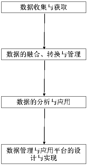
[0046] figure 1A schematic flow chart of the spatial data integration method provided in this embodiment, such as figure 1 Shown, a kind of eco-spatial data integration method, this method comprises the following steps:
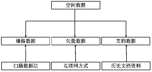
[0047] 1. Data collection and acquisition, obtaining spatial data, including raster data, vector data and document data;
[0048] 2. Data fusion, conversion and management, using the acquired data, data conversion through the spatial data conversion model, and complete data standardization management;
[0049] 3. Data analysis and application, analyze the relationship between the element categories and attributes of the original data and the target data, and check the analysis results from various aspects such as position accuracy, attribute accuracy, element integrity, and element relationship;
[0050] 4. The design and implementation of the data management and application platform, through the cloud storage scheme design of the analysis data, and the est...
Embodiment approach
[0070] The main implementation methods are as follows:
[0071] 4.1, WebGIS provides a dedicated Web interface for spatial databases through the public gateway interface CGI, where CGI is a standard technology for connecting application software and Web servers;
[0072] 4.2, through the further strengthening of HTML functions, CGI integrates HTML to easily realize interactive and dynamic communication. Among them, the GIS plug-in adopts the Client / Server architecture, and some GIS functions on the server are pushed to the client;
[0073] 4.3. In the Hadoop distributed big data processing environment, WebGIS big data visualization technology can dynamically combine distributed components and collaboratively process and analyze spatial data.
[0074] Through the above implementation, the component-based WebGIS makes the real network GIS possible. It can collect, store, manage, calculate, analyze, display and describe the whole or part of the big spatial data through computer h...
PUM
 Abstract
Description
Claims
Application Information