Unmanned aerial vehicle visual attitude and position calculation method based on image marking

A technology for image marking and drones, applied in the field of drone navigation, can solve problems such as failure to meet practical requirements

Active Publication Date: 2020-11-20
BEIHANG UNIV
View PDF1 Cites 11 Cited by
  • Summary
  • Abstract
  • Description
  • Claims
  • Application Information

AI Technical Summary

Problems solved by technology

However, the domestic UAV visual technology-guided ship landing control technology research is still in the stage of software simulation and semi-physical simulation, and has failed to meet the practical requirements.

Method used


Image

  • Unmanned aerial vehicle visual attitude and position calculation method based on image marking
  • Unmanned aerial vehicle visual attitude and position calculation method based on image marking
  • Unmanned aerial vehicle visual attitude and position calculation method based on image marking

Examples


Embodiment 1

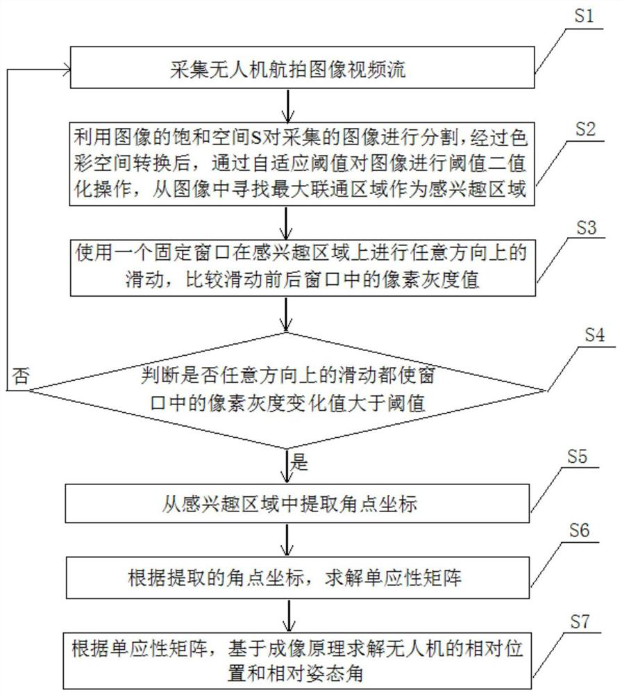
[0101] The first step: the feature mark extraction of the visual mark, which is subdivided into the following steps:

[0102] (1) Acquisition of UAV aerial image video stream

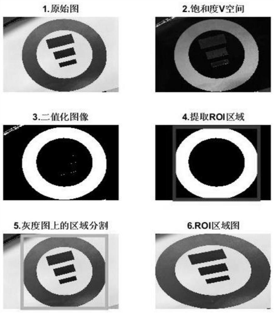
[0103] (2) Extract the region of interest

[0104] Considering that the global corner point extraction takes a long time, the region of interest is used to shorten the global feature corner detection. In the HSV color space, H represents the hue, and its range is 0 to 360°; V represents the brightness of the image, and its value is usually 0 to 1, 1 (or 100%) represents the highest brightness, and 0 represents the darkest brightness ;S stands for saturation, which means the degree to which the color is close to the spectral color, and the ratio between it and the corresponding brightness space. Vivid, 0 means only the gray value corresponding to the brightness. The present invention utilizes the saturation space S of the image, and ideally, uses the S space to segment the collected image, and can eff...


PUM


Abstract

The invention discloses an unmanned aerial vehicle visual attitude and position resolving method based on image marking. The unmanned aerial vehicle visual attitude and position resolving method comprises the steps of collecting an aerial image video stream of an unmanned aerial vehicle, extracting a region of interest from an image, extracting angular point coordinates from the region of interest, solving a homography matrix, and solving a relative position and a relative attitude angle of the unmanned aerial vehicle based on an imaging principle. The problem of relatively long time of globally carrying out corner detection is considered, therefore, the retrieval circular ring area is used for carrying out angular point detection on the area in the circular ring; in this way, the calculation amount can be reduced, the operation time can be shortened, the real-time performance of pose determination can be improved, interference of miscellaneous points outside a circular ring can be avoided, the anti-interference capacity can be improved, meanwhile, the three rectangles are adopted, target angular points can be efficiently extracted, and the angular points can be conveniently markedand matched. According to the method, high course measurement precision and high position measurement precision can be kept for a long time, and the method is suitable for application occasions withhigh requirements for the relative position and attitude precision of the unmanned aerial vehicle when two moving carriers such as a landing carrier converge.

Description

technical field [0001] The invention relates to the technical field of unmanned aerial vehicle navigation, in particular to a method for resolving the visual attitude and position of an unmanned aerial vehicle based on image marking. Background technique [0002] UAV navigation technology is one of the key technologies for UAV system to realize autonomous flight. Commonly used navigation technologies for drones mainly include inertial navigation, GPS navigation, visual navigation, radio navigation, and terrain-assisted navigation. The realization of functions such as UAV path planning, real-time obstacle avoidance, precise landing, landing and flight control requires the navigation module to provide continuous and comprehensive navigation information, and landing is an area that requires extremely high navigation technology. [0003] Unmanned aerial vehicle landing is different from landing on the ground. The ship is equivalent to a non-stop mobile airport at sea, and the ...

Claims


Application Information

Patent Timeline
Patent Type & Authority Applications(China)
IPC IPC(8): G06T7/11G06T7/136G06T7/50G06T7/70G06K9/32G06F17/16G01C21/20
CPCG06T7/11G06T7/136G06T7/50G06T7/70G06F17/16G01C21/20G06V10/25
Inventor 王学运张京娟陈刚于泽龙
Owner BEIHANG UNIV
Why Eureka
Try Eureka