
Multi-source sensing comprehensive integrated composite navigation micro-system collaborative design platform

A technology of comprehensive integration and composite navigation, applied in the field of multi-source sensor comprehensive integration composite navigation microsystem collaborative design platform, can solve the problems of difficult interactive sharing of data, long research and development cycle, and difficult research and development, so as to shorten the development iteration cycle, Improve efficiency and accuracy, and improve the effect of forward design capabilities

Active Publication Date: 2021-04-30
INFORMATION SCI RES INST OF CETC
View PDF6 Cites 7 Cited by
  • Summary
  • Abstract
  • Description
  • Claims
  • Application Information

AI Technical Summary

Problems solved by technology

[0003] At present, the design of the navigation microsystem is usually after the completion of the design of each sub-module, and then the integrated simulation is carried out in a unified way. There is a lack of integrated design technology for the composite navigation microsystem, and the system integrity cannot be guaranteed before the process is manufactured, nor can it achieve high confidence. design optimization
Moreover, there are differences in tool types and versions in the existing platforms of relevant designers, and it is difficult to share data interactively. The research and development costs are high and difficult, and product development often requires multiple iterations, resulting in low efficiency in microsystem design. The cycle is long, which affects the development progress and efficiency of the system

Method used


Image

  • Multi-source sensing comprehensive integrated composite navigation micro-system collaborative design platform
  • Multi-source sensing comprehensive integrated composite navigation micro-system collaborative design platform
  • Multi-source sensing comprehensive integrated composite navigation micro-system collaborative design platform

Examples


Embodiment Construction

[0068] In order to enable those skilled in the art to better understand the technical solutions of the present invention, the present invention will be further described in detail below in conjunction with the accompanying drawings and specific embodiments.

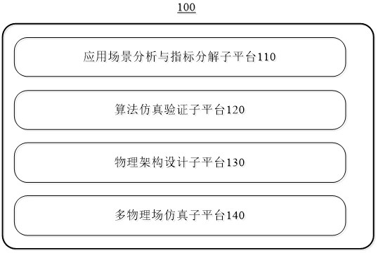
[0069] like figure 1 As shown, this implementation provides a multi-source sensing integrated composite navigation microsystem collaborative design platform 100. The platform 100 includes an application scenario analysis and index decomposition sub-platform 110, an algorithm simulation verification sub-platform 120, a physical architecture design sub-platform 130 and Multiphysics simulation sub-platform 140 .

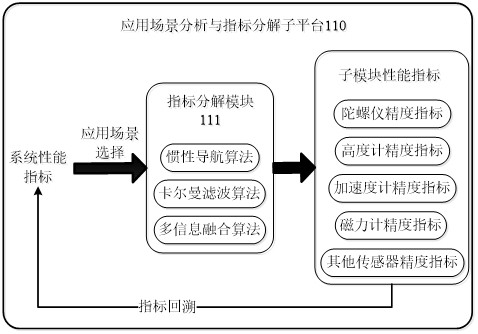
[0070] The application scenario analysis and index decomposition sub-platform 110 is used to plan the system functions of the navigation microsystem, design the system performance index and system architecture according to the accuracy requirements of different application scenarios, and decompose the system perfor...


PUM


Abstract

The invention provides a multi-source sensing comprehensive integrated composite navigation micro-system collaborative design platform, which comprises an application scene analysis and index decomposition sub-platform used for planning system functions, designing system performance indexes and a system architecture according to different application scene precision requirements, decomposing the system performance indexes into sensor performance indexes, and correcting system performance indexes according to the sensor performance indexes; an algorithm simulation verification sub-platform used for establishing an algorithm simulation model according to the system architecture; a physical architecture design sub-platform used for establishing a physical architecture model according to the system architecture; and a multi-physical field simulation sub-platform used for performing multi-physical field simulation according to the physical architecture model to obtain a final design model. The collaborative design and verification of the overall level of the system and the levels among the units can be realized, the high-confidence design optimization of the overall performance of the system before manufacturing is ensured, the forward design capability is improved, the project development iteration period is shortened, and the development efficiency and accuracy are improved.

Description

technical field [0001] The invention belongs to the technical field of navigation microsystems, and in particular relates to a multi-source sensing integrated composite navigation microsystem collaborative design platform. Background technique [0002] The microsystem has the characteristics of multi-specialty and multi-level, and the composite navigation microsystem with multi-source sensor integrated architecture is a typical representative. Multi-source sensing integrated composite navigation microsystem consists of MEMS inertial measurement unit (including three-axis accelerometer and gyroscope), satellite navigation unit, micro altimeter, micro magnetometer, digital processing chip, etc. to achieve high-density integration through microsystem technology, Realize deep fusion of multi-source navigation information through algorithms and dedicated chips. The navigation microsystem senses the acceleration, angular velocity, height of the moving carrier and the magnetic fie...

Claims


Application Information

Patent Timeline
Patent Type & Authority Applications(China)
IPC IPC(8): G06F30/23G06F30/17G06F30/367G06F30/39G01C21/18G01C21/16G01C21/20G06F119/14
CPCG01C21/165G01C21/18G01C21/20G06F30/17G06F30/23G06F30/367G06F30/39G06F2119/14
Inventor 李苗叶雨农王皓岩刘杰李嵬
Owner INFORMATION SCI RES INST OF CETC
Learn More