Strip mine muck pile data rapid obtaining and processing method

A processing method and technology for open-pit mines, applied in image data processing, mapping and navigation, and re-radiation utilization, etc., which can solve the problems of difficult management and sharing, poor synchronization of collection, and poor practicability.

Pending Publication Date: 2021-09-03
鞍钢矿业爆破有限公司
View PDF0 Cites 0 Cited by
  • Summary
  • Abstract
  • Description
  • Claims
  • Application Information

AI Technical Summary

Problems solved by technology

[0004] Aiming at the deficiencies in the prior art, such as poor practicability, difficulty in data acquisition, and poor acquisition synchronization in open-pit mine blasting data, the problem to be solved by the present invention is to provide a solution that can solve the acquisition and processing of open-pit mine blasting data. Quick acquisition and processing method of open-pit mine explosion data with problems such as low efficiency, difficult management and sharing

Method used


Image

  • Strip mine muck pile data rapid obtaining and processing method

Examples


Embodiment 1

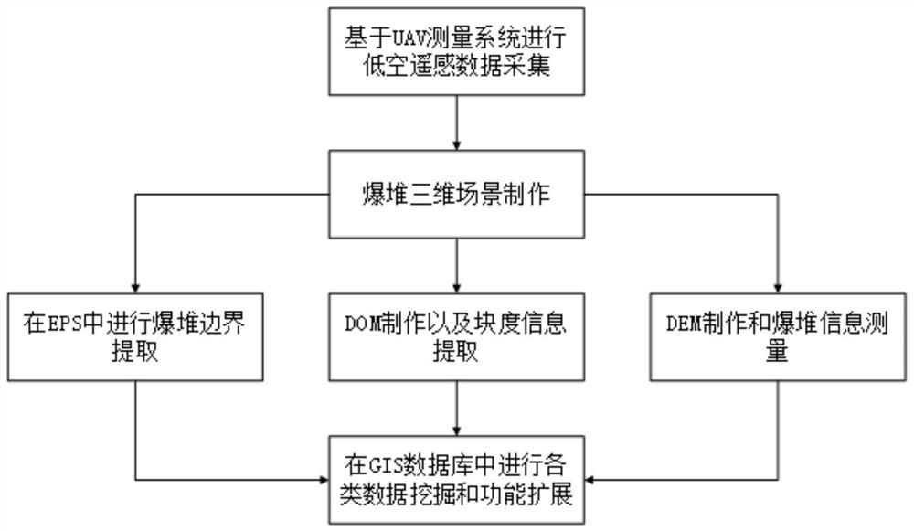
[0024] like figure 1 Shown, the present invention provides a kind of open-pit mine blast pile data fast acquisition and processing method, realizes based on unmanned aerial vehicle (UAV) measuring system, is applicable to the fast acquisition and processing work of open pit mine blast pile form related data, comprises the following steps:

[0025] 1) The UAV is equipped with a photogrammetry system, a 3D laser scanner and a GPS navigation system to collect low-altitude remote sensing data. The technical requirements refer to GB6962-2005 "1:500, 1:1000, 1:2000 Scale Topographic Map Aerial Photography Specifications" Execute, obtain point cloud data and image data;

[0026] 2) import point cloud data and image data into three-dimensional modeling software (the present embodiment adopts context capture software) to process, restore the three-dimensional scene of the explosion pile, and obtain digital surface model (DSM) data;

[0027] 3) Import the DSM data into the digital line...

Embodiment 2

[0038]The difference between this embodiment and Embodiment 1 is that a DJI S1000 V eight-rotor UAV is equipped with a Panasonic GH4 digital camera and a Leica ScanStation P50 three-dimensional laser scanner to form a UAV measurement system. The camera has 36.4 million pixels, the highest resolution is 7360*4912, and the weight of the whole machine is 0.465kg; the long distance of the 3D laser scanner can reach 1000m, and the ranging accuracy in the 270m mode is 1.2mm+10ppm. The relative altitude of the UAV measurement system is 360m, the lateral overlap is 70%, and the heading overlap is 60%.

[0039] According to the measurement, the maximum throwing distance of blasting broken rock is 107m; the orthophoto map of the blasting pile measurement area was made, and the highest resolution of the DOM this time was 3cm; The three-dimensional model of the explosion pile is restored on the workstation, the grid spacing of the DEM is 0.5m, and the range of the explosion pile outline i...

Embodiment 3

[0041] The difference between this embodiment and Embodiment 1 and Embodiment 2 is that a Sirius Sirius Pro drone is used to carry a Sony RX1RII digital camera and a Topcon GLS-2000 three-dimensional laser scanner to form a UAV measurement system. The camera has 36.4 million pixels, the highest resolution is 7360*4912, and the weight of the whole machine is 0.507kg; the distance measurement accuracy of the 3D laser scanner is 3.5mm (1-150m), 1s igma, and the angle measurement accuracy is 6". The relative flight height of the UAV measurement system is 380m, 70% sideways overlap and 60% heading overlap.

[0042] According to the measurement, the maximum throwing distance of the blasted rock is 93m; the highest resolution of DOM is 2.0cm; The grid spacing of the grid is 0.6m, the range of the blasting pile outline is expanded by 15 meters, the blasting pile height is 10.2m, the stacking angle is 28.2°, and the blasting pile volume is about 2650m 3 .


PUM


Abstract

The invention provides a strip mine muck pile data rapid obtaining and processing method. The method comprises the steps of: enabling an unmanned aerial vehicle system to collect and obtain point cloud data and image data, and processing the point cloud data and the image data through three-dimensional modeling software to obtain digital surface model data; performing digital line drawing data editing of the muck pile distribution boundary, recording boundary vector line drawing coordinates, and importing data into CAD; processing the image data; carrying out image binarization operation on the muck pile image, and extracting a muck pile lumpiness size s; recovering the muck pile three-dimensional model, and collecting muck pile characteristic elements; importing the digital elevation model into CAD, measuring the height, stacking angle and volume of the muck pile, and recording data; and respectively classifying the data meeting the data standard, converting the data into a mining area geographic information system database, and automatically generating a muck pile database. According to the invention, intelligent acquisition and processing of muck pile data are realized, practicability, shareability and real-time synchronism of the muck pile data are improved, and the method is suitable for rapid acquisition and processing of strip mine muck pile form related data.

Description

technical field [0001] The invention relates to a mining and surveying and mapping project, in particular to a method for quickly acquiring and processing explosive stack data in an open-pit mine. Background technique [0002] At present, open-pit mine blasting data has a wide range of sources, a large amount of data, asynchronous and difficult data acquisition, and insufficient data sharing, resulting in low practicability and poor shareability of relevant blasting data. The comprehensive evaluation of transportation efficiency and blasting quality has a serious impact. In the prior art, a UAV-based measurement system acquires a panoramic image of the explosion, and realizes data extraction and measurement of multiple areas of the explosion through image processing technology, but the acquired data has high redundancy and poor data practicability. Another method is to use 3D laser scanning technology to measure and calculate the volume of open-pit stope explosion. This met...

Claims


Application Information

Patent Timeline
Patent Type & Authority Applications(China)
IPC IPC(8): G01S19/39G01S17/89G01C11/00G06T17/20G06F30/12
CPCG06F30/12G06T17/20G01C11/00G01S17/89G01S19/39
Inventor 张耿城耿威张日强于忠滢袁增森
Owner 鞍钢矿业爆破有限公司
Why Eureka
Try Eureka