Terrain sensing method and system thereof, storage medium and computer equipment

A technology of terrain perception and terrain parameters, which is applied to measuring devices, instruments, and measuring ultrasonic/sonic/infrasonic waves, etc. It can solve problems such as short walking paths, less time spent, collisions or overturning accidents, etc.

Active Publication Date: 2021-10-01
CHONGQING VOCATIONAL INST OF ENG
View PDF14 Cites 4 Cited by
  • Summary
  • Abstract
  • Description
  • Claims
  • Application Information

AI Technical Summary

Problems solved by technology

[0014] Autonomous navigation problem: The inspection robot is equipped with a camera or an infrared thermal imager to observe the equipment. The size of the electrical equipment in the observation field of view determines the accuracy of data collection. Therefore, when the inspection robot performs global path planning, it not only reflects the Avoiding obstacles, the shortest walking path, and the least time spent, etc., it is also necessary to select an appropriate observation distance and observation angle to determine the appropriate observation range of each electrical device
The ground conditions will not be detected by the lidar, and the inspection robot will pass directly through this road section, and there may be a collision or rollover accident

Method used


Image

  • Terrain sensing method and system thereof, storage medium and computer equipment
  • Terrain sensing method and system thereof, storage medium and computer equipment
  • Terrain sensing method and system thereof, storage medium and computer equipment

Examples


Embodiment Construction

[0063] In order to make the object, technical solution and advantages of the present invention more clear, the present invention will be further described in detail below in conjunction with the examples. It should be understood that the specific embodiments described here are only used to explain the present invention, not to limit the present invention.

[0064] Aiming at the problems existing in the prior art, the present invention provides a terrain sensing method, system, storage medium, and computer equipment. The present invention will be described in detail below with reference to the accompanying drawings.

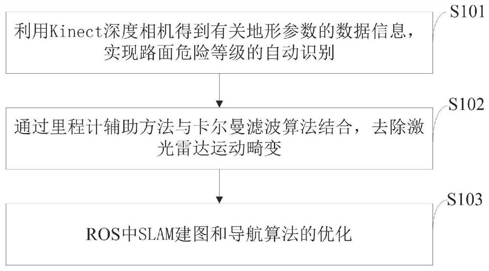
[0065] Those of ordinary skill in the industry of the terrain perception method provided by the present invention can also adopt other steps to implement, figure 1 The terrain perception method provided by the present invention is only a specific embodiment.

[0066] Such as figure 1 As shown, the terrain perception method provided by the embodiment of the prese...


PUM


Abstract

The invention belongs to the technical field of terrain perception, and discloses a terrain perception method and a system thereof, a storage medium and computer equipment, a Kinect depth camera is utilized to obtain data information related to terrain parameters, and automatic identification of a road surface danger level is realized; a speedometer auxiliary method is combined with a Kalman filtering algorithm to remove laser radar motion distortion; and SLAM mapping and navigation algorithm optimization in ROS is realized. According to the method, the robot is globally positioned on the X axis and the Y axis, the distance error is smaller than 10 cm, and the angle error is smaller than 0.2 rad; the size error between the grid map and the real environment is less than 1cm; the deviation degree between the real navigation path of the robot and the algorithm estimation path is less than 10cm; the mobile robot can carry out loopback when mapping is carried out in an environment with a similar structure; and the variance of the preprocessed point cloud data collected by the laser radar is less than 0.1.

Description

technical field [0001] The invention belongs to the technical field of terrain perception, and in particular relates to a terrain perception method, system, storage medium, and computer equipment. Background technique [0002] At present, my country is rich in coal resources, and coal is still the main energy source in my country. In recent years, the coal industry has successively proposed concepts such as mechanized substitution and intelligent unmanned. In January 2019, the National Coal Mine Safety Supervision Bureau released the "Catalogue of Key R&D of Coal Mine Robots", announcing 38 types of coal mine robots in 5 categories for key R&D and application by coal enterprises, scientific research institutions, and manufacturing enterprises, among which inspection robots are safety control robots. A sort of. [0003] In recent years, the state has stepped up efforts to rectify and standardize the intrinsically safe management of coal mines, and at the same time vigorousl...

Claims


Application Information

Patent Timeline
Patent Type & Authority Applications(China)
IPC IPC(8): G01H17/00
CPCG01H17/00Y02T10/40
Inventor 寇子明游青山贺晓辉陈婧金书奎
Owner CHONGQING VOCATIONAL INST OF ENG
Why Eureka
Try Eureka