Integrated routing/mapping information system

a routing/mapping information system and information system technology, applied in traffic control systems, navigation instruments, instruments, etc., can solve the problems of limited user choice, limited information fragments, and limited multi-media travelog information to preplanned scenic tours, so as to facilitate pda/gps configuration location marking and breadcrumb or gps log functions, enabling mating and cooperation

Inactive Publication Date: 2003-09-25
KHOURI ANTHONY
View PDF0 Cites 868 Cited by
  • Summary
  • Abstract
  • Description
  • Claims
  • Application Information

AI Technical Summary

Benefits of technology

[0013] It is an object of the present invention to provide a new integrated routing / mapping information system (IRMIS) capable of enabling the mating and cooperation between desktop and handheld devices, including the automatic updating of related databases whenever the desktop PC and handheld PDA link together. The PDA or handheld personal organizer may be optionally linked to a GPS receiver. It is also an object of the present invention to provide the means to take advantage of the strengths of the desktop or home-base application which provides wider geographical coverage and a fully implemented map / route / point-of-interest (poi) cartographic system, which desktop enables user selectivity or customization of map and route information--optionally tapping into online information. It is another object of the present invention to create data-cutting alternatives such that certain user selections of geographic area, start, finish, POIs, levels of detail or map magnitudes may be effectively downloaded to the PDA / GPS that produce compact map and / or route information "packages" comprising black-white bitmaps, text directions lists, point information organized in differential magnitude configurations which e.g. provide more detail and particular kinds of information around waypoints, less detail and perhaps more major road driving information along the routes between waypoints. It is a further object of the present invention to provide a means to enable a PDA to display text directions and maps (without GPS), serving similar functions to map / itinerary travel plan printouts and to facilitate in a PDA / GPS combination a map display of user's current position, and / or prompting and beeped warnings relative to text directions, as well as heading, distance, speed and other real time GPS data. The present invention is further designed to facilitate in a PDA / GPS configuration location marking and breadcrumb or GPS log functions which can be displayed on the PDA and / or uploaded, displayed, and otherwise processed back at the home-base desktop. Yet a further object of the present invention is the development of a PDA / GPS application can include programming whereby the GPS output controls map / point / route information content and levels of detail--as illustrated by "automatic zoom" upon arrival at area mapped at lesser / greater level of detail or, when a GPS receiving system "senses" that the vehicle has slowed down or stopped, map and point information displays automatically refocus or "look about" to see about restaurants, lodgings or other area attractions.
[0016] The present invention is an improvement over the prior art of simple PDA operations in that the IRMIS technology enables advanced map displays, rather than simple textual information. It permits current-position displays when linked with GPS. Moreover, the developed PDA system of the present invention can act as a personal organizer as well as a "hotsynch" link between truly portable devices and desktop devices.
[0018] Another advantage is that IRMIS users in the field may simultaneously navigate a travel route generated by IRMIS software while recording or tracking locations or sequences of locations. Such locations may be designated by the user as new POIs and sequences of locations may be transferred from the GPS receiver to the IRMIS desktop platform as an ordered waypoint list that designates a new travel route. Further, fast and accurate surveying is enabled from GPS receiver location recording data made by the user in the field when transferred to the IRMIS desktop platform for computerized data mapping by the IRMIS software.
[0023] The IRMIS software permits user selection of a particular map, area, or a point of interest. The IRMIS software further enables routing and the extraction or cutting of a route as well as area maps for downloading to the PDA. The IRMIS route map that is developed is essentially a larger scale map encompassing a start and a finish of the route. Included is at least one map of more detailed, greater resolution and / or higher magnitude maps of the start, the finish, and, possibly, other waypoints or POIs. That is, the present invention permits the user to select an area or route on the desktop computer-displayed maps and create PDA maps that are cut in accordance with that selection. This is an advantage over the prior art which was limited to pre-cut, one-size-fits-all maps for specific regions, areas, or cities.

Problems solved by technology

While the Rand McNally product incorporates a database of many points of interest, the multimedia travelog information appears limited to preplanned scenic tours.
However the multimedia information available from the database appears limited to "suggested routes of travel" again limiting user choice.
In each case it appears that travel information from multimedia sources is preassembled by editors so that the user or trip planner is limited to "canned" or prepared multimedia travelogs of prescribed, suggested, or preplanned tours.
Or the user is limited to information fragments about this or that particular object of interest or this or that particular place.
There is no opportunity or user capability and selectivity in constructing a user-customized travelog of assembled multimedia information for previewing a particular user determined route of travel.
A disadvantage of the Trimble GPS navigation tool is that it provides a display of coordinate system data only in alphanumeric characters on a multiline LCD display.
Furthermore, the Trimble navigation device does not provide communications access to other geographical information databases for updated information on geographical objects in the spatial area of interest or communications access to other software tools for map analysis and reading.
More generally, the Trimble navigation device does not provide a communications dimension for the map reading system.
It cannot display multiple geographical objects at the same time and cannot communicate with other sources of spatially related map information.
PDA cannot to date provide such capacity.
Prior attempts at enabling PDA usage in regard to selectable travel routes has been limited to single-route textual itineraries.

Method used


Image

  • Integrated routing/mapping information system
  • Integrated routing/mapping information system
  • Integrated routing/mapping information system

Examples


Embodiment Construction

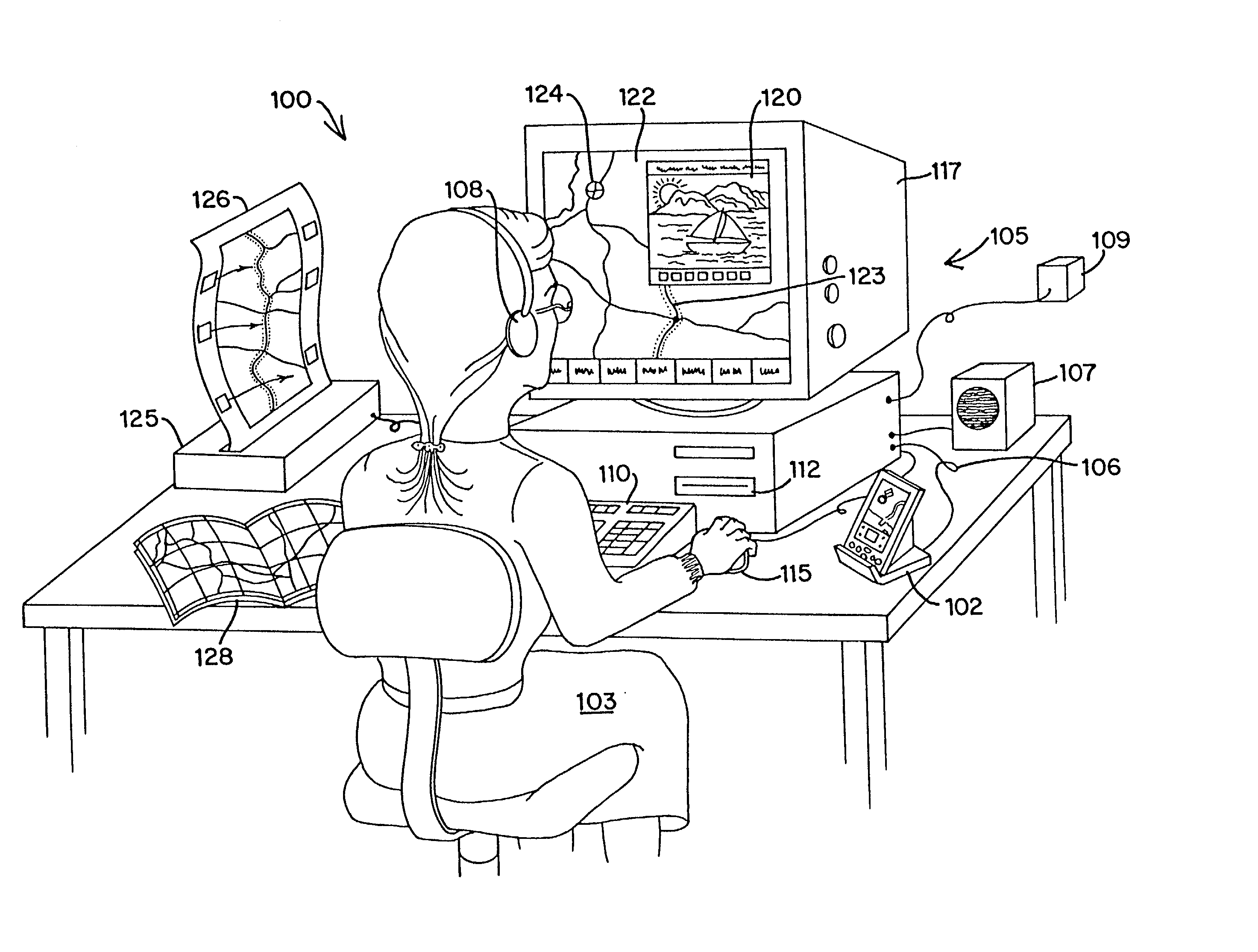
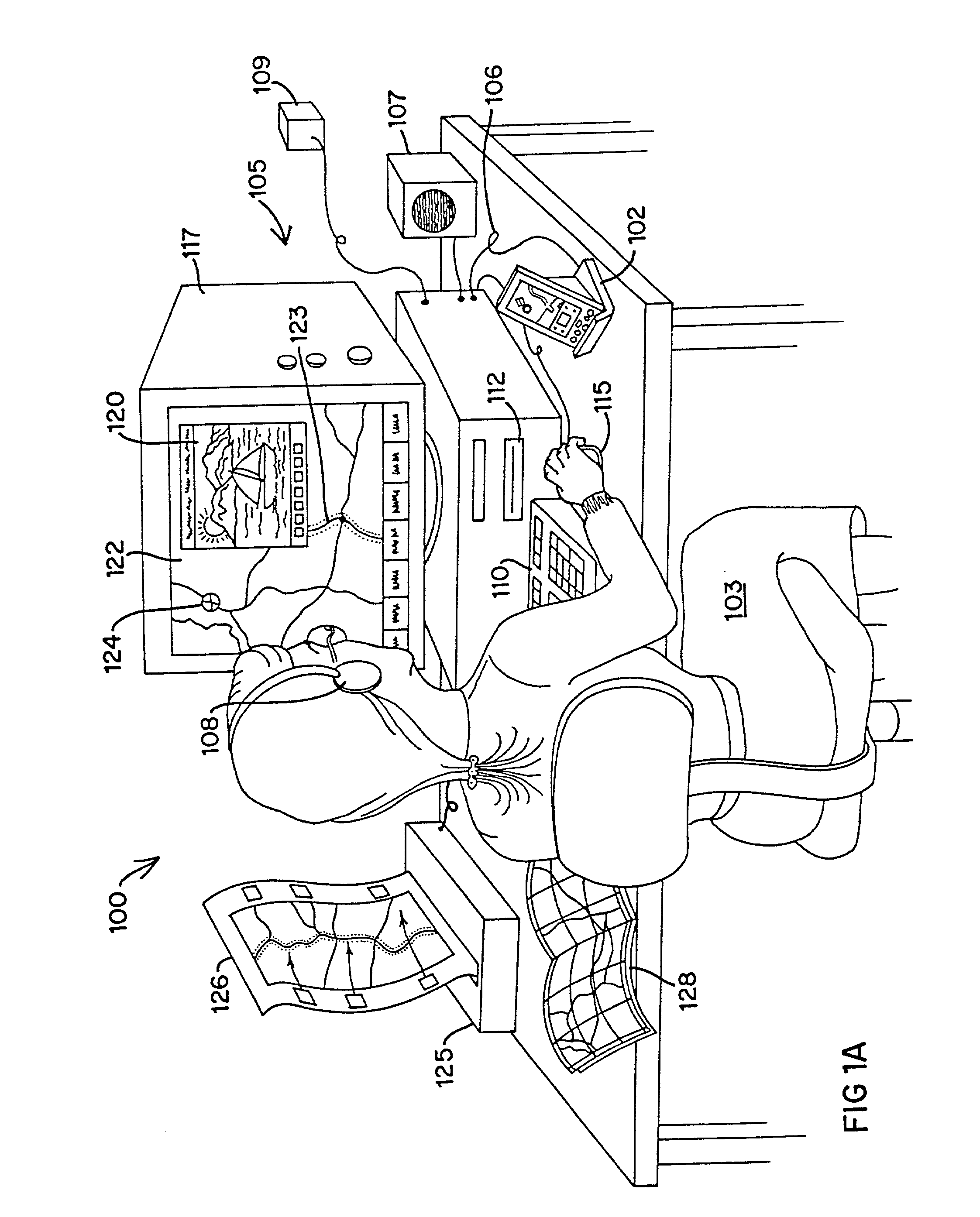
[0042] An IRMIS 100 according to the present invention is illustrated by way of example in FIG. 1A. A user 103 operates the software system 100, provided on CD-ROM, utilizing a desktop personal computer equipped for multimedia. In the preferred embodiment, illustrated in FIG. 1A, the desktop computer system 105 includes a 286, 386, 486, or Pentium (.TM.) Intel (.TM.) processor or equivalent, with typical memory devices, associated circuitry and peripheral devices including a monitor or cathode ray tube (CRT) 117, a speaker or audio system 107, a printer 125, a CD-ROM player 112, a mouse 115 or similar pointing device, and keyboard 110. Alternatively, the software for the desktop system 105 can be provided on diskette, run from a hard drive or central server (e.g., a local area network internally linked to a mainframe or externally linked to the Internet as shown at 109).

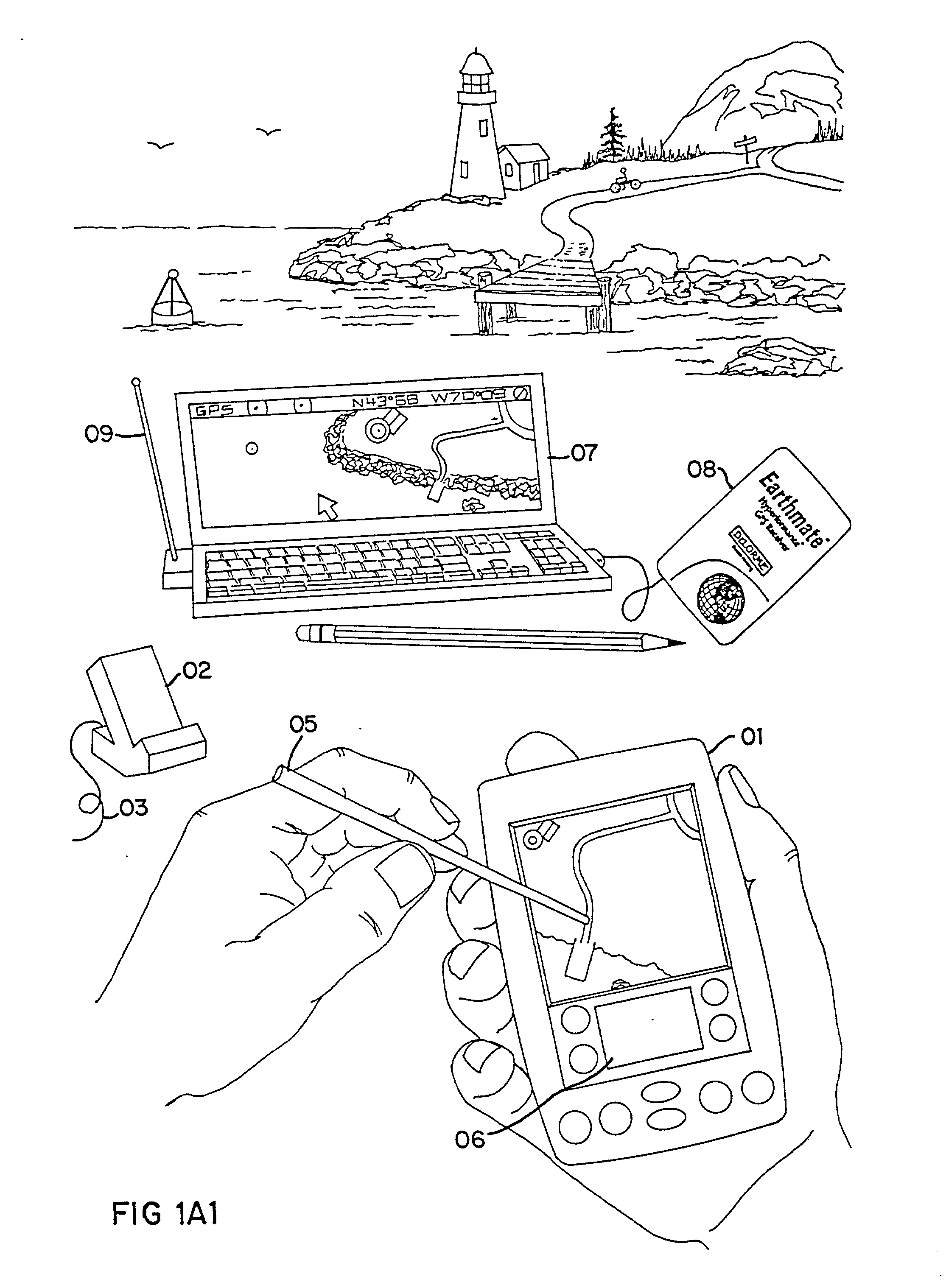
[0043] Included for use with IRMIS 100, the desktop computer 105 is integrated with a handheld or palmtop personal...


PUM


Abstract

An Integrated Routing / Mapping Information System (IRMIS) links desktop personal computer cartographic applications to one or more handheld organizer, personal digital assistant (PDA) or "palmtop" devices. Such devices may be optionally equipped with, or connected to, portable Global Positioning System (GPS) or equivalent position sensing device. Desktop application facilitates user selection of areas, starts, stops, destinations, maps and / or point and / or route information. It optionally includes supplemental online information, preferably for transfer to the PDA or equivalent device. Users' options include route information, area, and route maps. Maps and related route information are configured with differential detail and levels of magnitude. Used in the field, in conjunction with GPS receiver, the PDA device is configured to display directions, text and map formats, the user's current position, heading, speed, elevation, and so forth. Audible signals identifying the next turn along the user's planned route are also provided. The user can pan across maps and zoom between two or more map scales, levels of detail, or magnitudes. The IRMIS also provides for "automatic zooming," e.g., to show greater detail or closer detail as the user approaches a destination, or to larger scale and lower resolution to show the user's overall planned route between points of interest. The IRMIS also enables the user to mark or record specific locations and / or log actual travel routes, using GPS position information. These annotated location marks and / or "breadcrumb" or GPS log data can be saved, uploaded, displayed, or otherwise processed on the user's desktop geographic information or cartographic system. The IRMIS application and data may be distributed online and / or in tangible media in limited and advanced manipulation formats.

Description

CROSS REFERENCE TO REPLATED PATENT APPLICATION[0001] This patent application is a continuation-in-part (CIP) of the David M. DeLorme et al U.S. patent application Ser. No. 08 / 661,600 filed Jun. 11, 1996, for COMPUTER AIDED ROUTING AND POSITIONING SYSTEM, which is a CIP of U.S. patent application Ser. No. 08 / 381,214 filed Jan. 27, 1995 for COMPUTER AIDED ROUTING SYSTEM, now U.S. Pat. No. 5,559,707, issued Sep. 24, 1996, which is a CIP of the David M. DeLorme et al U.S. patent application Ser. No. 08 / 265,327 filed Jun. 24, 1994 for COMPUTER AIDED MAP LOCATION SYSTEM and the contents of these related patent applications are incorporated herein by reference.[0002] This invention relates to a new Integrated Routing / Mapping Information System (IRMIS) for travel planning, travel guidance, and recording travel locations and paths during business or recreational use, particularly in regard to the linkage of small, memory-limited computing systems with personal and / or mainframe computers. The...

Claims


Application Information

Patent Timeline
Patent Type & Authority Applications(United States)
IPC IPC(8): G01C21/34G01C21/36G01S19/35G06Q10/02G06Q10/04G08G1/0969G09B29/10
CPCG01C21/26G01C21/3476G01C21/36G06Q10/047G06Q10/02G08G1/0969G09B29/106G01C21/3679
Inventor DELORME, DAVID M.GRAY, KEITH A.AUTRY, GORDONMOULTON, KEITH A.
Owner KHOURI ANTHONY
Why Eureka
Try Eureka