[0009] Accordingly, a typical conventional geospatial
data request takes the form of a user query indicative of a particular area and type of output image or map. Such conventional requests typically employs a GIS or
remote sensing specialist familiar with the relevant data sets and trained in the applicable
image processing operations. Such a request may be, for example, an operation combining three dimensional
elevation data with ground permeability to identify likely flood areas due to be used by a real estate developer or insurance company. Another example might illustrate a shift over time (temporal), such as an operation which detects the changes in
vegetation over time for a specific area which could be used to illustrate the effect of a polluted river. However, the conventional end user requesting the data does not possess the expertise to create these datasets themselves and therefore relies on the skills of a
third party. The end user therefore experiences an often lengthy
lag time in fulfilling the
data request, conveying the request to the GIS specialist, and waiting for the GIS specialist to process it from the raw imagery. Further, a discrepancy or misunderstanding may result in an erroneous or inaccurate result, compounding the
lag time due to repeated and / or refined efforts. Accordingly, users may anticipatorily request geospatial data output on the mere potential to need such output at a future time. Such preemptory requests tend to increase the overall
workload, increase
response time for all requests, and result in output geospatial data sets which are likely to be “mothballed,” or passively stored, until obsolete or not relevant to the matter for which they were procured.
[0011] Therefore, because of the costs involved with processing and managing geospatial data, the
raw data sets and resulting synthesized output sets are viewed as an important asset by the organizations maintaining and providing such geospatial output to the consumers of the data. Accordingly, geospatial data sets are the subject of
license, maintenance, and ownership agreements of substantial value. By some accounts, as much as 2% of all Federal spending is directed toward acquisition, storage, and processing of geospatial data. Accordingly, it would be beneficial to provide a
system and method for provisioning geospatial data to facilitate delivery of the output geospatial
data set as a product to the end user as one method of increasing the utilization of the assets, reducing duplicity and reducing overall asset management costs.
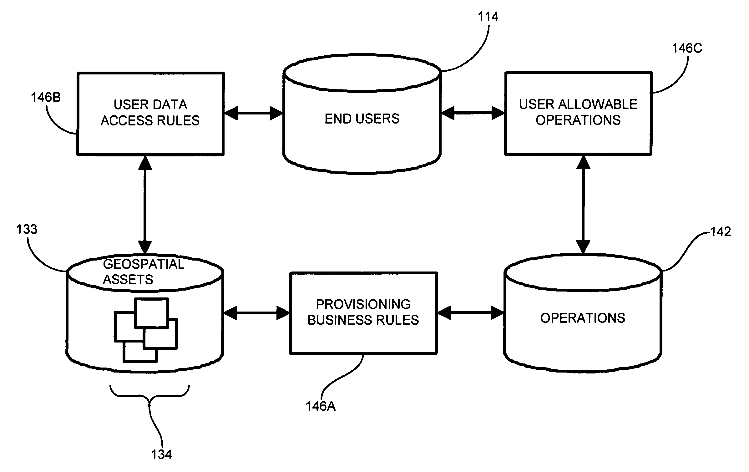
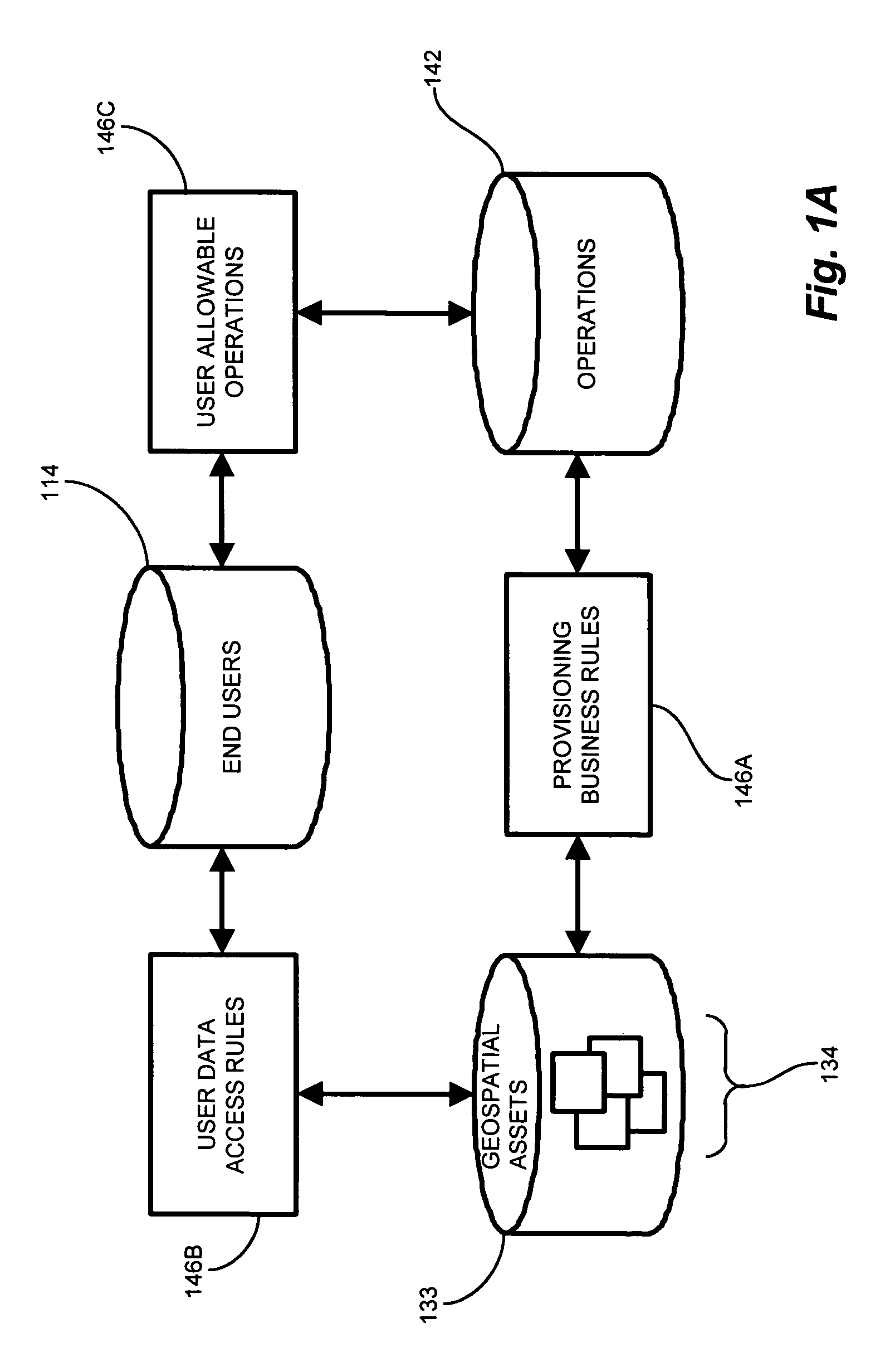
[0013] The spatial data provisioning process consists of several integrated components. A data catalog records the attributes of specific data sources and stores this information in a
relational database system indexed based on the geographical location of each asset. The catalog provides search and retrieval capabilities based on spatial, temporal and the various data attributes. The geospatial data is typically stored in its original source format—both in
file format and spatial context, and is then provisioned specific to the needs of each end user. In this sense, provisioning includes certain image manipulations to reprocess, reproject, resample, reformat and combine various datasets in rapid fashion. Centralized
business logic rules, or transformation rules, apply to the creation of specific derivative data sets to automate repetitive and complex image creation requests. These business rules are linked to specific types of data or combinations of data and are accessed based on the policies of each organization. The application of these business rules to the geospatial assets reduce errors, assure consistency, reduce the required end user
skill level and generally allow end users to easily integrate these assets into traditional decision support operations. In this manner, spatial data provisioning as discussed herein represents the next generation of managing and disseminating spatial data.
[0017] In particular configurations, the geospatial data provisioning application employs the transformation rules to define appropriate relations between users, geospatial data sets, or sources, and operations on the data. A catalog, such as a local application repository, is generated and maintained to store information about the available data sets, including available attributes therein, the
geographic area to which the
data set pertains, and
low resolution graphical information to enable a
thumbnail image of the area. The catalog allows the user to identify available operations, based on the privileges defined in the transformation rules, and obtain a preview of the resulting transformed data set prior to retrieving the entire raw geospatial data set from a remote source. Once selected, the user receives the output data product resulting from the user specific selection of data sets and operations. Further, the provisioning framework provided by the transformation rules allows new data sets, attributes, and operations to be integrated merely by updating the rules to recognize the new data sets, attributes, and applicable operations, thus providing a seamless integration of new geospatial data gathering and sensing capabilities.
[0021] In particular configurations, identifying the plurality of geospatial data sets further involves gathering
metadata from each of the available geospatial data sets, identifying available attribute values in the geospatial data sets from the
metadata, and
cataloging the geospatial data sets for subsequent retrieval according to the available attributes and geographic region covered. Gathering, or retrieving geospatial data sets may further include identifying a portion of the geospatial data set corresponding to the area of interest, and retrieving only the attribute data corresponding to the area of interest, mitigating network traffic associated with transporting entire raw geospatial data sets when only a portion thereof is requested. Such geospatial data typically includes various forms and types of data, representing aspects such as
terrain elevation,
satellite and aerial images, detailed street maps and geometrical models of buildings and similar man-made structures (including present, past and future structures).

