Relative positioning

a relative positioning and positioning technology, applied in the field of positioning, can solve problems such as a significant amount of time, adversity of user experience, and error in the baseline solution

Inactive Publication Date: 2013-12-17
NOKIA TECHNOLOGLES OY
View PDF16 Cites 13 Cited by
  • Summary
  • Abstract
  • Description
  • Claims
  • Application Information

AI Technical Summary

Benefits of technology

[0040]The invention enables an improved performance of a relative positioning by providing additional information that can be exploited in several ways. As a result, the invention may contribute to the reliability and quality of a positioning solution and thus to the improved quality of an application making use of the positioning and to an improved user experience. The invention also allows expanding the use cases of a relative positioning, like an mRTK based positioning. In practice, a high positioning accuracy may be provided in completely new environments.
[0042]This allows finding the relative position in situations, in which the availability of other data used in the positioning is limited. In the case of a satellite signal based relative positioning, for example, this embodiment allows finding the relative position in more demanding environments, in which signals from a smaller number of satellites is available than usual.
[0045]When using the determined altitude difference for removing at least one of the unknown relative position values, the integer ambiguity resolution is faster in some cases, and therefore, the best accuracy is obtained more quickly.
[0048]This provides an additional approach for validation that is independent of any statistical measures typically used for validation. It allows rejecting incorrect solutions, ever if a statistical validation process should incorrectly validate the solution. The result is a more reliable performance and, therefore, improved user experience.
[0050]In this embodiment, the baseline may be tracked with less available data than needed previously. In the case of a satellite signal based relative positioning, for example, this embodiment allows, similarly as in the case of a first fix, updating the relative position in more demanding environments.
[0056]It can further be used with any kind of relative positioning, in particular, though not exclusively, a positioning making use of a GNSS, like GPS, GLONASS, GALILEO, SBAS, QZSS, LAAS or a combination of these. LAAS has the advantage that it enables the use of mRTK under indoor conditions as well.

Problems solved by technology

The involved waiting time might be the cause of an adverse user experience.
If phase locks are lost so that less than four common satellites are in phase lock, the integer ambiguities must be re-initialized, which takes a significant amount of time.
However, this induces an error in the baseline solution.
Similar problems may occur in other relative positioning approaches, which rely on the availability of a sufficient amount of data.

Method used


Image

  • Relative positioning
  • Relative positioning
  • Relative positioning

Examples


Embodiment Construction

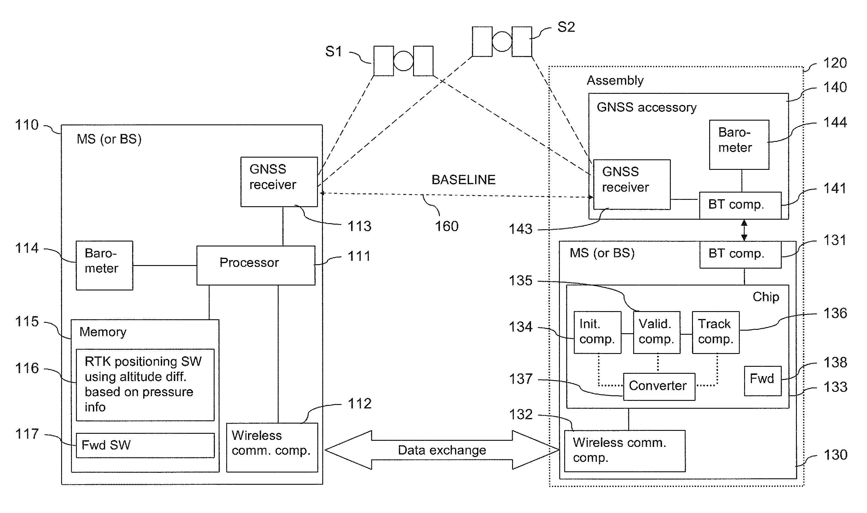
[0065]FIG. 1 presents an exemplary system according to the invention, which enables an enhanced relative positioning by making use of barometric pressure information.

[0066]The system comprises a mobile device 110 and a mobile assembly 120.

[0067]The mobile device 110 is assumed by way of example to be a mobile station (MS), like a cell phone. It comprises a processor 111 and, linked to this processor 111, a wireless communication component 112, a GNSS receiver 113, a barometer 114 and a memory 115.

[0068]The processor 111 is configured to execute implemented computer program code. The memory 115 stores computer program code, which may be retrieved by the processor 111 for execution. The stored computer program code includes RTK positioning software (SW) 116 and / or forwarding software 117.

[0069]The mobile assembly 120 is assumed by way of example to comprise a mobile station (MS) 130 and a separate GNSS accessory device 140.

[0070]The mobile station 130 includes a chip 133 and, linked t...


PUM


Abstract

For supporting a relative positioning, information on barometric pressure at a first device and information on barometric pressure at a second device is converted into a difference in altitude between the first device and the second device. The difference in altitude between the first device and the second device is then used in determining a position of the first device relative to the second device.

Description

CROSS REFERENCE TO RELATED APPLICATIONS[0001]This application is the U.S. National Stage of International Application Number PCT / IB2006 / 053366 filed on Sep. 19, 2006 which was published in English on Mar. 27, 2008 under International Publication Number WO 2008 / 035139.FIELD OF THE INVENTION[0002]The invention relates to a positioning of a device relative to another device.BACKGROUND OF THE INVENTION[0003]An absolute positioning of a device is supported by various Global Navigation Satellite Systems (GNSS). These include for example the American Global Positioning System (GPS), the Russian Global Navigation Satellite System (GLONASS), the future European system Galileo, the Space Based Augmentation Systems (SBAS), the Japanese GPS augmentation Quasi-Zenith Satellite System (QZSS), the Locals Area Augmentation Systems (LAAS), and hybrid systems.[0004]The constellation in GPS, for example, consists of more than 20 satellites that orbit the earth. Each of the satellites transmits two car...

Claims


Application Information

Patent Timeline
Patent Type & Authority Patents(United States)
IPC IPC(8): G01C5/06G01C5/04G06F3/00G06F3/03G01S5/14G01S19/43G01S19/45
CPCG01C5/06G01S19/43G01S19/45G01S5/0072
Inventor WIROLA, LAURIALANEN, KIMMO
Owner NOKIA TECHNOLOGLES OY
Why Eureka
Try Eureka