Spectrum collecting system for water surface imaging of shallow lake and synchronous automatic monitoring method
An imaging spectrum and automatic monitoring technology, applied in the field of environmental remote sensing monitoring, can solve the problems of satellite data atmospheric correction errors, high operating costs, interference, etc., and achieve the effects of rapid and stable operation, stable operation, and convenient maintenance.
- Summary
- Abstract
- Description
- Claims
- Application Information
AI Technical Summary
Problems solved by technology
Method used
Image
Examples
Embodiment 1
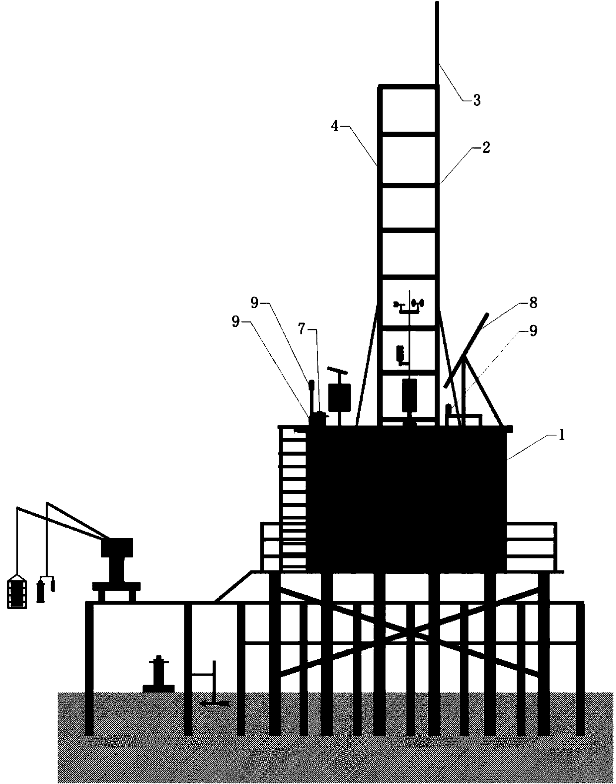
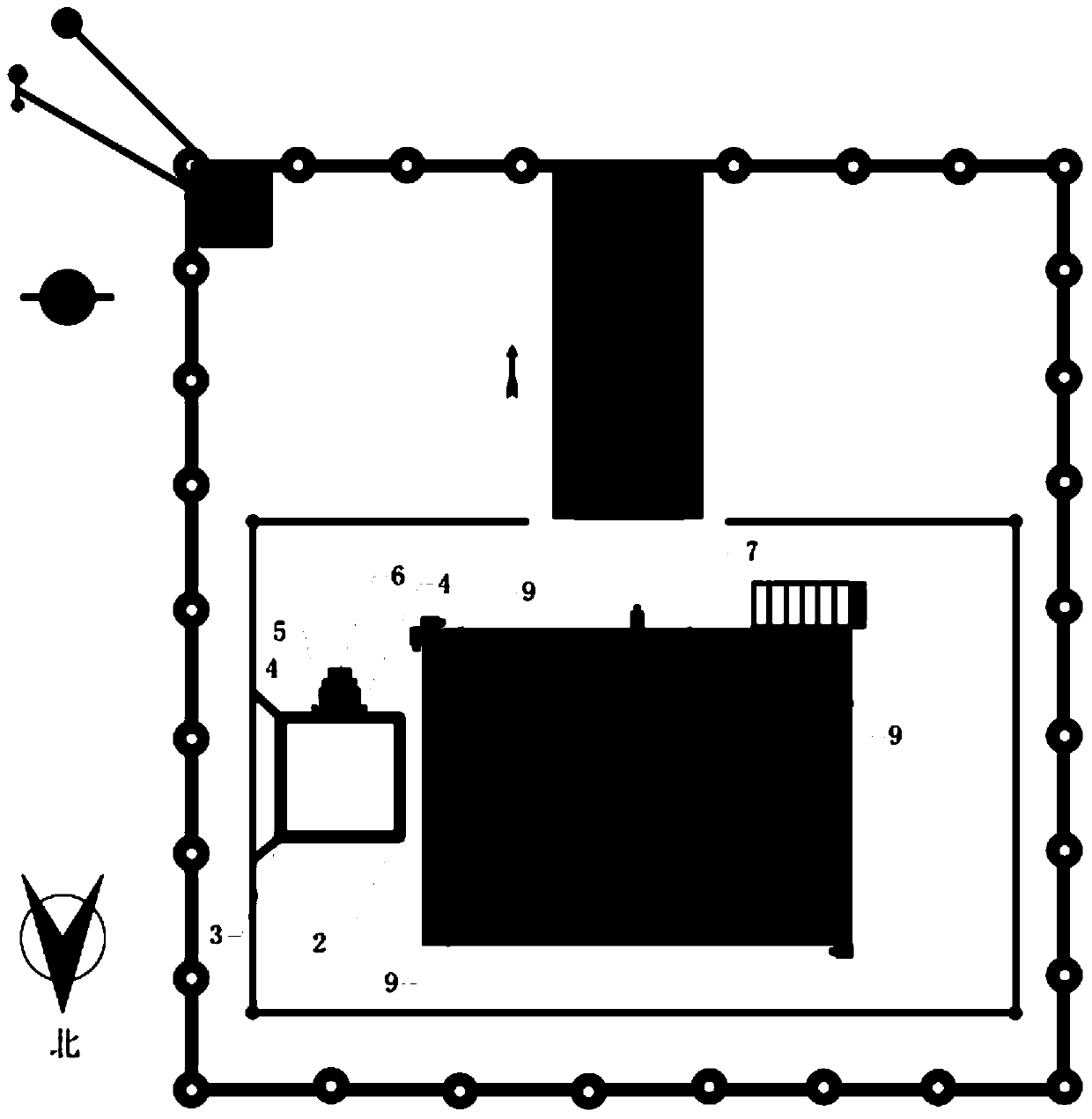
[0060] Figure 1a , 1b, 1c and 1d are structural schematic diagrams of the present invention, as shown in the figure, the shallow lake water surface imaging spectrum automatic monitoring system, the system includes a support platform, a power supply system, an imaging spectrum data acquisition system, a data transmission system, and a data center.
[0061] The supporting platform must be 1m higher than the historical highest water level in the water area where it is located. It is supported by a total of 48 pipe piles, each of which is 8m long. The rain-proof instrument room, at the same time, in order to facilitate the operation of the platform, a stainless steel ladder is welded on one side of the instrument room to reach the roof, and the imaging spectrometer on the other side observes the tower 2. This platform system can bear a huge load, can maintain sufficient stability under the attack of typhoon and flood, and can exist for a long time under high temperature and high h...
Embodiment 2
[0068] image 3 It is a flow chart of the present invention, as shown in the figure, an automatic monitoring method using the shallow lake surface imaging spectrum automatic monitoring system described in Embodiment 1, the method includes the following steps:
[0069] (1) Use the solar panel 8 to convert solar energy into electrical energy and store it in the battery pack 11 on sunny days; source;
[0070] (2) Use the camera to collect video images of the water surface within a radius of 500m; then, according to the characteristics of algal blooms or water color changes on the lake surface, extract and transmit the water color change information in the image through the built-in program of the data transmission system to the data center, and choose an appropriate time to carry out Imaging spectrometer experimental work;
[0071] (3) According to the characteristics of water color changes in eutrophic lakes, the water surface imaging spectrometer 6 that is related to the wate...
PUM
 Abstract
Description
Claims
Application Information
 - R&D
- Intellectual Property
- Life Sciences
- Materials
- Tech Scout
- Unparalleled Data Quality
- Higher Quality Content
- 60% Fewer Hallucinations
Browse by: Latest US Patents, China's latest patents, Technical Efficacy Thesaurus, Application Domain, Technology Topic, Popular Technical Reports.
© 2025 PatSnap. All rights reserved.Legal|Privacy policy|Modern Slavery Act Transparency Statement|Sitemap|About US| Contact US: help@patsnap.com


