Indoor offline path guide method and system based on GPS

A path guidance and navigation system technology, applied in radio wave measurement systems, satellite radio beacon positioning systems, navigation and other directions, can solve the problems of affecting signal strength, short transmission distance, and high complexity of positioning systems, and achieve a reduced complexity. Effect

Inactive Publication Date: 2014-09-10
CHONGQING UNIV
View PDF7 Cites 9 Cited by
  • Summary
  • Abstract
  • Description
  • Claims
  • Application Information

AI Technical Summary

Problems solved by technology

Since the indoor environment is not like the outdoors, there are fixed roads, so according to the spatial distribution of indoor obstacles, there are many paths to choose from, which makes the path selection algorithm very complicated and the amount of calculation is huge
[0007] Infrared rays are easily blocked by objects or walls during transmission and the transmission distance is relatively short. The complexity of the positioning system is high, so the effectiveness and practicability are low.
Moreover, the unique ID of the object under test needs to be sent periodically through the infrared transmitter to the infrared receiver fixedly placed indoors, so the power consumption is large and the cost is high
[0008] The main defect of ultrasonic technology is its limited range of positioning, which is due to the obvious attenuation of ultrasonic waves during transmission.
Moreover, a large number of electronic tags need to be installed, the investment is large, and the practicability is not strong
[0009] For indoor positioning technology based on radio frequency identification (RFID), the disadvantage is that the positioning accuracy of the system is determined by the position of the reference tag, which will directly affect the positioning effect. However, in order to improve the positioning accuracy, it is necessary to increase the density of the reference tag. However, the density A higher value will generate greater interference and affect the signal strength
In addition, because the distance between the reference label and the pending label needs to be calculated by calculating the Euclidean formula, the amount of calculation is large

Method used


Image

  • Indoor offline path guide method and system based on GPS
  • Indoor offline path guide method and system based on GPS
  • Indoor offline path guide method and system based on GPS

Examples


Embodiment 1

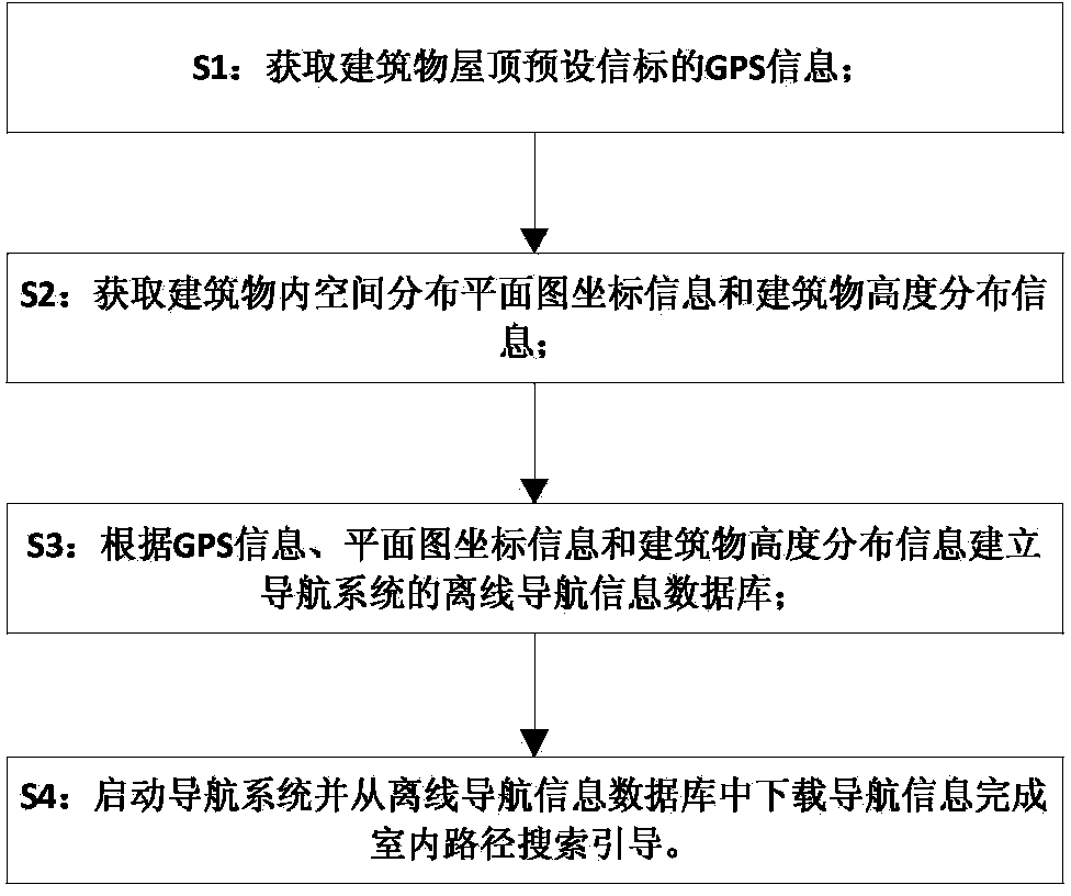
[0033] figure 1 It is a flow chart of a GPS-based indoor offline path guidance method, as shown in the figure: the GPS-based indoor offline path guidance method provided by the present invention includes the following steps: 1) acquiring the GPS information of the preset beacon on the roof of the building; 2) acquiring 3) Establish the offline navigation information database of the navigation system according to the GPS information, the coordinate information of the floor plan and the building height distribution information; Download the navigation information in and complete the indoor route search and guidance.

[0034] Before the real navigation, some preparatory work needs to be done in advance, that is, the establishment of the offline database of the navigation system: first, obtain the floor plan of the indoor space distribution information of the building where the power distribution cabinet is located; then, determine according to the floor plan The position and num...

Embodiment 2

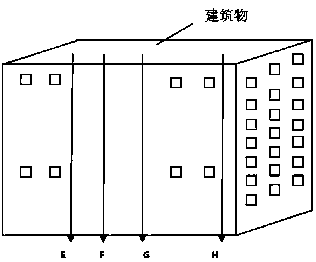
[0044] According to attached figure 2 As shown, E, F, G, and H in the building are four beacon points that need to know accurate GPS information, and A, B, C, and D are their vertical corresponding points on the roof. After the accurate GPS information of A, B, C, and D is measured on the roof by the handheld device, and projected vertically, the offline GPS information of E, F, G, and H can be obtained.

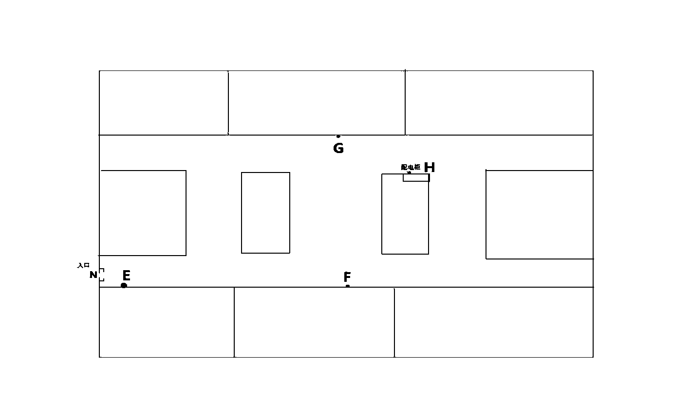
[0045] attached image 3 It is the plan view of the spatial distribution information in the building, the N point is the entrance point of the building, and the H point is the location of the power distribution cabinet in the building. Navigate to the entrance point N of the building through GPS satellite positioning, and then turn on the offline mode of the navigation system. According to the spatial distribution plan downloaded in advance and the offline GPS information of the beacon points, the GPS navigation system can plan such a route: Find point E at entrance N, th...


PUM


Abstract

The invention discloses an indoor offline path guide method and system based on the GPS. The method comprises the steps that firstly, GPS information of a preset beacon of the roof of a building is acquired; coordinate information of a spatial distribution plan of the interior of the building and height distribution information of the building are acquired; then, an offline navigation information database of the navigation system is established according to the GPS information, the coordinate information of the plan and the height distribution information of the building; finally, the navigation system is started and navigation information is downloaded from the offline navigation information database to complete indoor path search guide. According to the indoor offline path guide method and system based on the GPS, the offline navigation information database is adopted to determine path guide for a point, to be navigated, inside the building, so that indoor GPS navigation is made possible, and indoor GPS information has high precision when in use; indoor path guide can be achieved through an existing navigation technology; the complexity of path planning is lowered to a great degree.

Description

technical field [0001] The invention relates to a path guidance method and system, in particular to a GPS-based indoor offline path guidance method and system. Background technique [0002] In the field of indoor spatial distribution information map path guidance, for the actual indoor spatial distribution, since there is still no building indoor spatial information database that can be directly applied, it must be analyzed according to the actual situation, and the required environmental map can be obtained after processing. The layout of indoor space information. After obtaining the spatial information map, use the optimal path algorithm to plan the path on the map, so as to guide the indoor path in the building. [0003] The typical infrared indoor positioning system Activebadges attaches an electronic identification to the object to be tested, and the identification periodically sends the unique ID of the object to be tested to the infrared receiver fixedly placed in th...

Claims


Application Information

Patent Timeline
Patent Type & Authority Applications(China)
IPC IPC(8): G01S19/39
CPCG01C21/206G01S19/39
Inventor 段其昌杨祺
Owner CHONGQING UNIV
Why Eureka
Try Eureka