Basin rainfall monitoring wireless sensor network node optimization layout method

A wireless sensor and precipitation monitoring technology, applied in wireless communication, network topology, network planning, etc., can solve problems such as time-consuming, difficult to capture regional precipitation distribution, approximate true value error, etc.

Inactive Publication Date: 2016-12-28
CHINA INST OF WATER RESOURCES & HYDROPOWER RES
View PDF1 Cites 17 Cited by
  • Summary
  • Abstract
  • Description
  • Claims
  • Application Information

AI Technical Summary

Problems solved by technology

Due to the unbalanced regional development and the unreasonable planning of the early precipitation monitoring station network, some regional precipitation monitoring station networks are difficult to capture the distribution of regional precipitation and there are redundant stations. It is necessary to optimize the layout of precipitation monitoring stations
At present, the traditional pumping method is often used in the optimal layout of the precipitation monitoring station network to analyze the density of the station network for station optimization, and there are the following shortcomings in the application: (1) The average value of the precipitation data obtained by the traditional pumping method is used as the approximate true value of the precipitation in the area , using this as a standard to calculate the relative error of the combined station precipitation mean value relative to the approximate true value, simplify the existing dense precipitation monitoring station network within the allowable error range, and eliminate redundant stations. This method only considers the size of precipitation and ignores (2) On the basis of streamlining the existing stations, how to select effective methods and consider reasonable constraints to optimize the layout and add precipitation monitoring stations according to the precipitation characteristics of alpine and hilly areas, has become a digital Key points and difficulties in research on watershed information acquisition; (3) Although heuristic algorithms such as simulated annealing algorithm and genetic algorithm can improve the efficiency of site layout optimization, they take a long time and the calculation efficiency needs to be further improved

Method used


Image

  • Basin rainfall monitoring wireless sensor network node optimization layout method
  • Basin rainfall monitoring wireless sensor network node optimization layout method
  • Basin rainfall monitoring wireless sensor network node optimization layout method

Examples


Embodiment 1

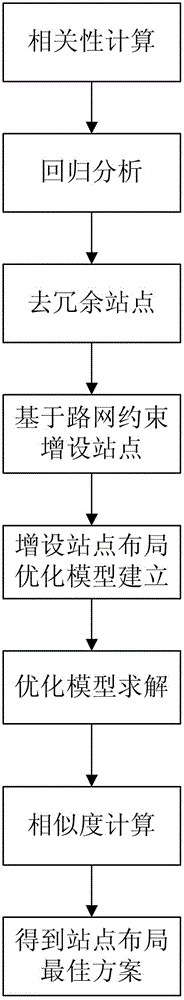
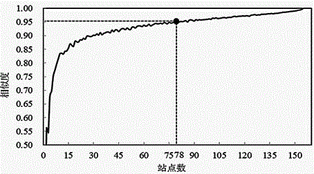
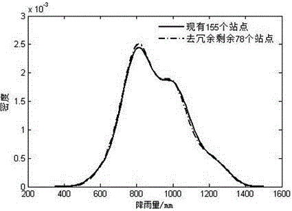
[0056] This embodiment is a method for optimizing the layout of wireless sensor network nodes for watershed precipitation monitoring. The method improves the traditional method of station extraction, and analyzes the density of the existing station network based on the improved station extraction method, removes redundant stations, and directly considers the restrictions on the feasibility of station deployment by the road network on this basis. Adding station alternative areas, adding stations in the alternative areas in turn, comprehensively using the correlation between the target variable precipitation and environmental variables such as latitude, longitude, elevation, slope, and aspect, to establish the site layout with regression Kriging variance as the objective function Optimization model, based on the parallel designed simulated annealing algorithm, through high-performance solution of the site layout optimization model, to achieve the optimized layout of precipitation ...

Embodiment 2

[0181] This embodiment is an improvement of the first embodiment, and is a refinement of the calculation of the correlation in the "steps of correlation calculation" in the first embodiment. The calculation of correlation in the "steps of correlation calculation" described in this embodiment includes the following sub-steps:

[0182] Calculate the annual average precipitation at each station according to the precipitation data obtained by the existing stations.

[0183] Obtain the slope and aspect data of the research area according to the DEM data of the research area where the existing site is located;

[0184] Extract the elevation, slope and aspect of the existing site according to the latitude and longitude information of the existing site;

[0185] Perform correlation analysis based on the annual average precipitation data and environmental variable data at the existing stations, and calculate the correlation coefficient and significance level between the target variable and the...

Embodiment 3

[0192] This embodiment is an improvement of the above embodiment, and is a refinement of the regression analysis described in the “steps of regression analysis” in the above embodiment. The regression analysis described in the "steps of regression analysis" described in this embodiment includes the following sub-steps:

[0193] According to the correlation coefficient and significance level between the target variable and the environmental variable, select the environmental variable that is significantly related to the average annual precipitation, namely the correlation coefficient p For environmental variables <0.05, generalized least square regression analysis is performed with the annual average precipitation to calculate the regression coefficient.

[0194] According to the generalized least squares regression coefficient, calculate the regression residual of precipitation at the existing station, and use GS+ software to calculate the variance function of the regression residua...


PUM


Abstract

The invention relates to a basin rainfall monitoring wireless sensor network node optimization layout method comprising the steps of correlation calculation; regression analysis; redundant site removing; additional arrangement of sites; additionally arranged site layout optimization calculation; and similarity calculation so that the optimal scheme of site layout can be obtained. The conventional site extraction method is improved, site network analysis is performed on existing rainfall site points based on the improved site extraction method, the redundant sites are removed, based on which the limitation of the road network on the feasibility of the site layout is directly considered, an optional area for additional arrangement of the sites is determined, the sites are additionally arranged in the optional area, a site layout optimization model is established with regression Kriging variance acting as a target function by comprehensively utilizing the correlation between the target variable rainfall and latitude and longitude, elevation, gradient, slope direction and other environmental variables, and the optimized layout of the rainfall monitoring sites is realized by solving the site layout optimization model in a high-performance way based on a parallel designed simulated annealing algorithm.

Description

Technical field [0001] The invention relates to a method for optimizing the layout of wireless sensor network nodes for water cycle monitoring in a river basin, and is a method for reasonably arranging precipitation monitoring stations. Background technique [0002] Precipitation is an important driving factor of the water cycle in the basin, and its accurate monitoring has important practical value for flood control and disaster reduction, water resources management, and hydrological forecasting and dispatching. At present, precipitation mainly depends on traditional ground monitoring and satellite remote sensing such as weather stations, precipitation monitoring stations, hydrological stations, etc. In traditional station network monitoring, the cost of station construction and maintenance is high, and it is difficult to establish a high-density precipitation monitoring station network, especially in mountain and valley areas. It is difficult to deploy stations. It is very diff...

Claims


Application Information

Patent Timeline
Patent Type & Authority Applications(China)
IPC IPC(8): H04W16/18H04W16/22H04W24/02H04W84/18
CPCH04W16/18H04W16/22H04W24/02H04W84/18
Inventor 冶运涛曹引梁犁丽蒋云钟尚毅梓赵红莉龚家国韩素华张双虎孙静杰
Owner CHINA INST OF WATER RESOURCES & HYDROPOWER RES
Why Eureka
Try Eureka