Time-space relationship analysis system based on multi-source Internet-of-things location sensing

A spatiotemporal relationship and analysis system technology, applied in relational databases, database distribution/replication, structured data retrieval, etc., can solve problems such as data structure confusion, semantic inconsistency, and agreement with different names, so as to reduce the difficulty of processing and improve fault tolerance. effectiveness, guaranteeing effectiveness

Pending Publication Date: 2017-06-13
航天精一(广东)信息科技有限公司
View PDF12 Cites 39 Cited by
  • Summary
  • Abstract
  • Description
  • Claims
  • Application Information

AI Technical Summary

Problems solved by technology

The data formats, standards, and structures of these data are different, and there are common problems of semantic inconsisten

Method used


Image

  • Time-space relationship analysis system based on multi-source Internet-of-things location sensing
  • Time-space relationship analysis system based on multi-source Internet-of-things location sensing
  • Time-space relationship analysis system based on multi-source Internet-of-things location sensing

Examples


Example Embodiment

[0060] In order to better understand the technical solutions proposed by the present invention, the present invention will be further described below in conjunction with the drawings and specific embodiments.

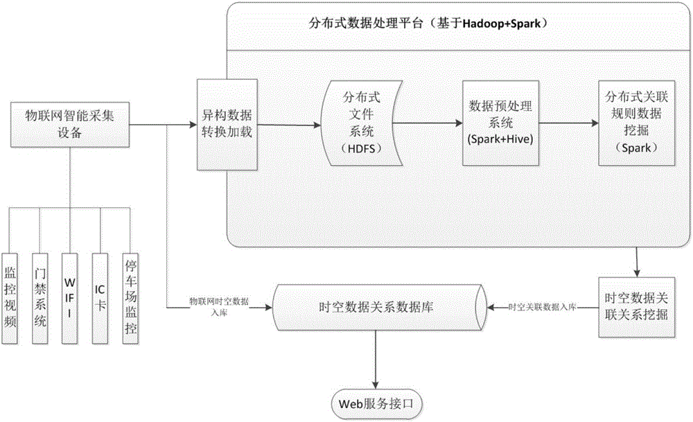
[0061] 1 system composition

[0062] Such as figure 1 As shown, a spatiotemporal data association analysis system based on multi-source IoT location perception consists of the following four levels:

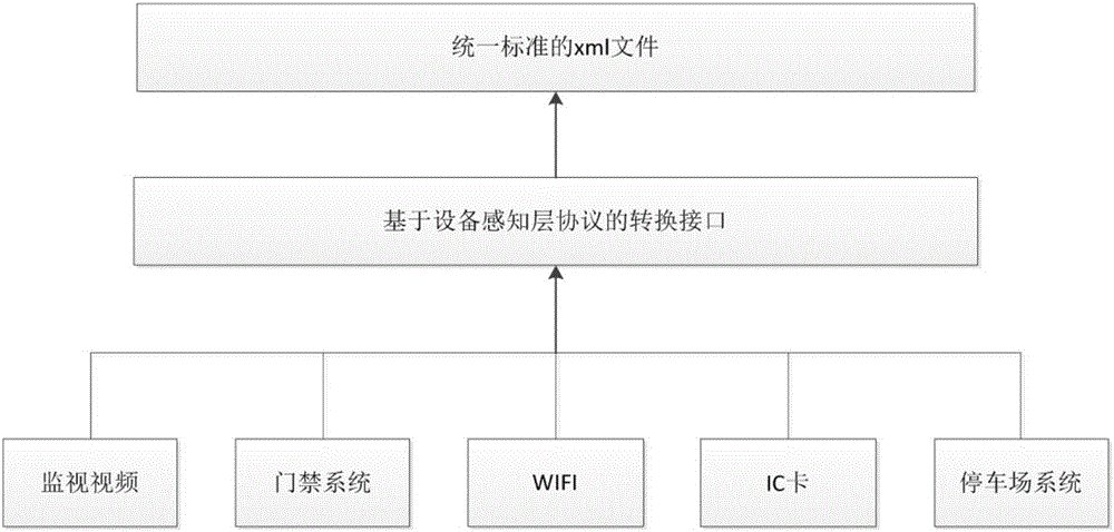
[0063] 1. Perception layer (data collection layer): It is composed of various terminal devices of the Internet of Things, including surveillance video, access control system, WiFi, IC card, parking lot monitoring, etc.;

[0064] 2. Data processing layer: It is composed of Hadoop distributed platform, spark big data processing framework and oracle relational database. Here, the Hadoop distributed framework in cloud computing is used for distributed data processing. Since the Hadoop distributed file system HDFS is aimed at supporting large data collections, HDFS is used for distribu...


PUM


Abstract

The invention provides a time-space relationship analysis system based on multi-source Internet-of-things location sensing. The system includes a sensing layer, a data processing layer, a network layer and an application layer; the sensing layer includes a variety of terminal equipment, and each terminal equipment can collect time-space data and provide original time-space data for the data processing layer; the data processing layer is used for receiving, filtering and cleaning the time-space data from the sensing layer, then exploiting the data according to the time-space association rule, storing the data to a time-space database, and providing an access interface for the network layer. According to the system, standardized heterogeneous data formats and various training models are adopted, multi-source Internet-of-things sensing data is reused in a multilevel model, and an efficient and predictable service is provided for an upper level policing application.

Description

technical field [0001] The invention belongs to the field of spatio-temporal relationship analysis, and relates to a spatio-temporal relationship analysis system, in particular to a spatio-temporal relationship analysis system based on multi-source Internet of Things position perception. Background technique [0002] At present, the vast majority of data applications in public security organs are still in the low-level and low-level application stages of information entry, release, statistics, and query, and the deep-level applications such as data integration, data mining, and data correlation analysis are not enough. [0003] CN106257301A discloses a massive video-based event trajectory fast retrieval platform, including a target trajectory spatiotemporal analysis module, an integrated scheduling service module, an intelligent video analysis service module, a resource request service module, and a monitoring video network and platform database, wherein the target trajectory...

Claims


Application Information

Patent Timeline
IPC IPC(8): G06F17/30
CPCG06F16/258G06F16/27G06F16/284G06F16/487G06F16/489G06F2216/03
Inventor 张宏利
Owner 航天精一(广东)信息科技有限公司
Why Eureka
Try Eureka