Flood forecasting service construction method based on WebGIS (Geographical Information System)

A technology for flood forecasting and construction methods, applied in forecasting, structured data retrieval, instruments, etc., can solve the problems of lack of validity inspection of water and rain data, long data update cycle, insufficient consideration of land use spatial differences, etc., to achieve rich Display content and performance methods, improve model forecast accuracy, and improve the effect of flood forecast accuracy

Inactive Publication Date: 2018-02-16
CHUZHOU UNIV
View PDF6 Cites 23 Cited by
  • Summary
  • Abstract
  • Description
  • Claims
  • Application Information

AI Technical Summary

Problems solved by technology

[0006] (1) The data source of the spatial model is single and the precision is low
[0007] The data source of traditional flood forecasting service geographic modeling generally comes from CAD or DEM constructed by CAD, and the data update cycle is long
In addition, due to the limitation of data security, it is difficult to obtain high-precision topographic data, and most of them use digital elevation models with 30m, 90m or even lower precision.
When the geospatial model constructed based on such data sources is applied to areas with large topographic changes in a short period of time and the river topography in plain areas, the model error is large
[0008] (2) Insufficient consideration of land use spatial differences
However, most of the flood forecasting models do not fully consider the factors that have changed the surface, resulting in insufficient forecast stability and large forecast errors
[0010] (3) Water and rain data lack validity test
[0011] Most flood forecasting models rely heavily on hydrometeorological and other data, but there is no effective inspection and analysis of the rationality and accuracy of water level and rainfall data. When the error is large, tens of thousands or hundreds of t

Method used


Image

  • Flood forecasting service construction method based on WebGIS (Geographical Information System)
  • Flood forecasting service construction method based on WebGIS (Geographical Information System)
  • Flood forecasting service construction method based on WebGIS (Geographical Information System)

Examples


Embodiment

[0142] Next, Changxing County, Zhejiang Province is selected as a sample area, and the present invention is described in detail.

[0143] (1) DEM construction

[0144] 1) Water conservancy engineering data processing

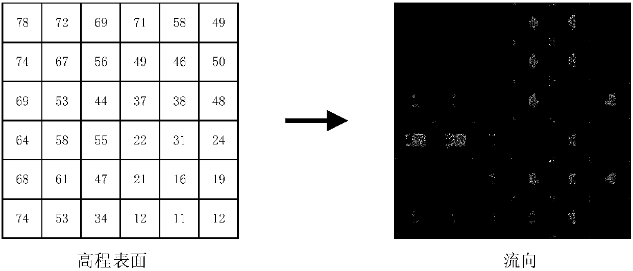
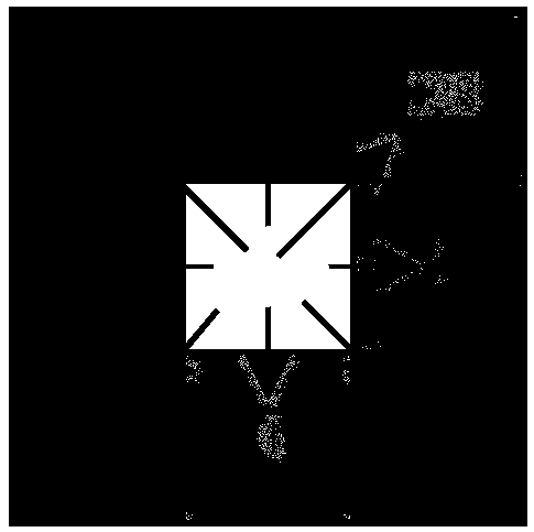
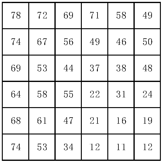
[0145] Collect topographic data of Changxing County (1:2000cad in 2014), typical hydrometeorological information of Changxing County over the years and hydrometeorological data (water level, rainfall, flow) in the past three years, land use map of Changxing County 1:10000, and remote sensing images. Use ArcGIS to process CAD data, extract topographic information (water system, land use), and construct DEM. Organize and analyze hydrometeorological data such as water level, precipitation, evaporation, flow and historical floods in the past year, and store them in the Oracle database.

[0146] 2) Terrain data processing: Extract elevation information (elevation points, grade lines) from CAD, and define CGCS2000 geodetic coordinates and 85 Yellow Sea elevation.

...


PUM


Abstract

The invention discloses a flood forecasting service construction method based on a WebGIS (Geographical Information System). The powerful space analysis technology of the GIS is fully utilized to be complementary with a traditional flood forecasting model to efficiently extract the natural converge information of the flood model so as to improve model forecasting accuracy. Meanwhile, WebGIS spaceinformation is used for expressing advantages so as to enable the flood forecasting to be more accurate and more visual in expression. The method comprises the following main steps that: (1) on the basis of terrain data, constructing a digital elevation model; (2) adopting a GIS space analysis method to preprocess a DEM (Dynamic Effect Model); (3) adopting a D8 algorithm to construct a running water network; (4) on the basis of a water flow direction and a soil water content, constructing a natural converge matrix; (5) utilizing a water flow accumulation value to generate a water channel in adrainage basin boundary, and carrying out hierarchical coding on the water channel on the basis of a Strahler method; (6) on the basis of a three-water-source XinAn River model, initially deciding andcalibrating parameters; and (7) on the basis of the WeBGIS, simulating a flood forecasting result.

Description

technical field [0001] The present invention relates to a flood forecasting service construction method based on WebGIS (WebGIS). Specifically, it uses WebGIS and flood forecasting models to construct flood evolution analysis services to realize dynamic flood forecasting results under different rain intensities and water regimes. Simulation and evolution analysis. Background technique [0002] Flood forecasting refers to the use of hydrological and meteorological information to simulate the formation process and movement of floods, and to forecast and simulate the possible location, time, intensity, scale, and process of floods. Flood forecasting, as an important non-engineering measure for flood control, has a wide range of application values ​​in the fields of flood control and emergency rescue, rational development and utilization of water resources and environment, water ecological protection and planning, water conservancy project planning and construction, and dispatch...

Claims


Application Information

Patent Timeline
IPC IPC(8): G06F17/30G06Q10/04G06Q50/26
CPCG06F16/29G06Q10/04G06Q50/265Y02A10/40
Inventor 曾微波殷晓飞王春江岭
Owner CHUZHOU UNIV
Why Eureka
Try Eureka