Workflow management method for collaborative remote sensing product production of multi-satellite data center

A technology for workflow management and remote sensing products, which is applied in the field of workflow management for multi-satellite data center collaborative remote sensing product production, can solve problems such as increasing the complexity of production workflow management and affecting the overall efficiency of multiple data centers, and achieves improved expansion performance, simplified model and implementation, and improved performance

Inactive Publication Date: 2018-12-11
INST OF REMOTE SENSING & DIGITAL EARTH CHINESE ACADEMY OF SCI
View PDF3 Cites 14 Cited by
  • Summary
  • Abstract
  • Description
  • Claims
  • Application Information

AI Technical Summary

Problems solved by technology

[0003] However, there are technical problems in building a distributed remote sensing data collaborative processing system by combining multiple satellite data centers
First of all, multi-source remote sensing data are distributed in different satellite data centers, and large-scale data migration in the production process affects the overall efficiency of multi-data center collaborative processing; second, remote sensing data processing itself requires complex processes such as pre-processing and post-processing, and multi-source There are huge differences in the processing flow of remote sensing data, which increases the complexity of production workflow management; in addition, comprehensive remote sensing

Method used


Image

  • Workflow management method for collaborative remote sensing product production of multi-satellite data center
  • Workflow management method for collaborative remote sensing product production of multi-satellite data center
  • Workflow management method for collaborative remote sensing product production of multi-satellite data center

Examples


Embodiment Construction

[0038] The following will clearly and completely describe the technical solutions in the embodiments of the present invention with reference to the accompanying drawings in the embodiments of the present invention. Obviously, the described embodiments are only some, not all, embodiments of the present invention. All other embodiments obtained by persons of ordinary skill in the art based on the embodiments of the present invention belong to the protection scope of the present invention.

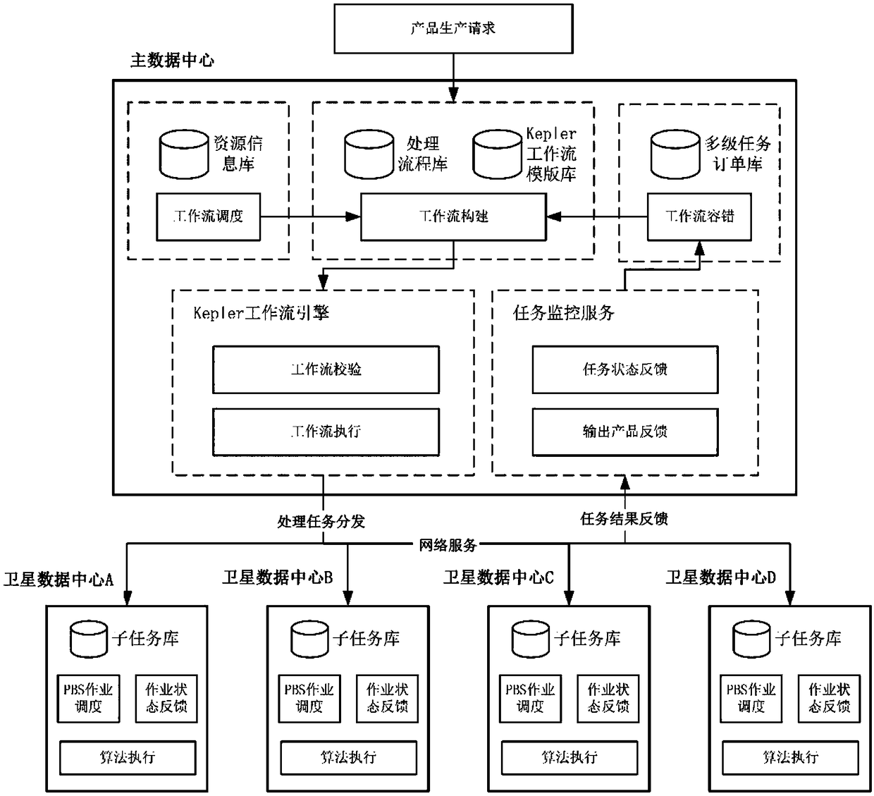
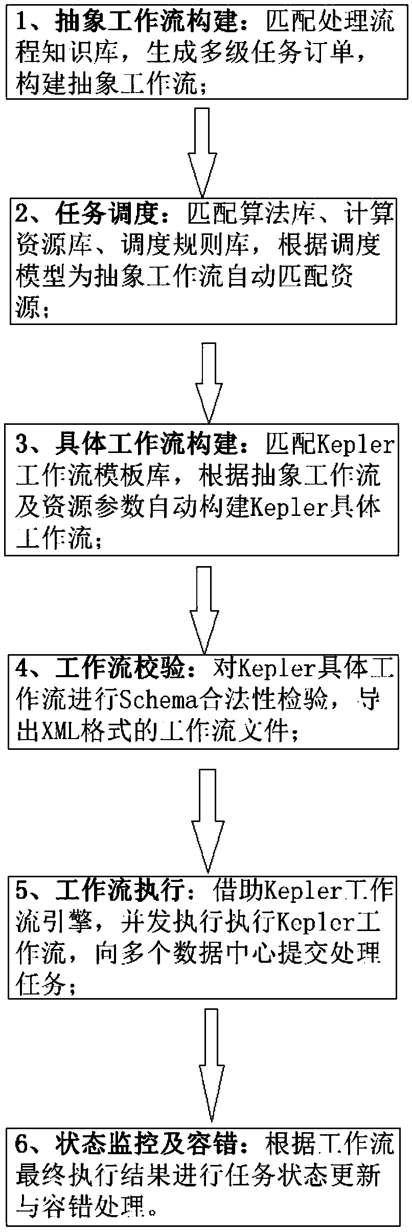
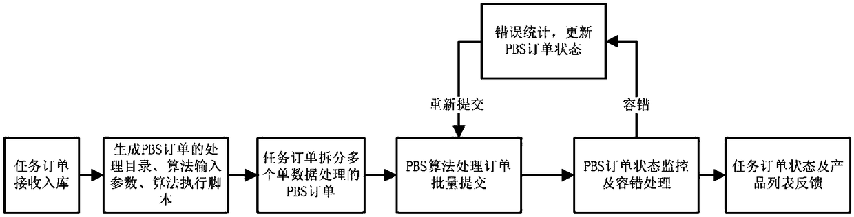
[0039] Such as figure 1 As shown, a workflow management method for multi-satellite data center collaborative remote sensing product production according to an embodiment of the present invention includes the following steps:

[0040]S1: Model induction of the usual processing flow of remote sensing product production, build a remote sensing product production processing flow library, and for a single flow in the flow library, build multi-source remote sensing data for differences in multi-sou...


PUM


Abstract

The invention discloses a workflow management method for collaborative remote sensing product production of a multi-satellite data center, the method comprising the following steps: constructing a remote sensing product production processing flow base, constructing a multi-source remote sensing data processing flow knowledge base, and constructing a multi-level task order base; according to Keplerdynamic workflow system and PBS job scheduling system, automatically constructing the specific task workflow with different granularity for remote sensing product production; formulating a heuristicworkflow dynamic scheduling strategy method; formulating a multi-level task status monitoring strategy related to remote sensing product production, and a fault tolerant strategy based on retry, checkpoint recovery and timeout; constructing a dynamic process library and algorithm library to realize the dynamic and scalable management of multi-satellite remote sensing workflow in a multi-satellitedata center.

Description

technical field [0001] The present invention relates to the technical field of satellite data centers, in particular to a workflow management method for multi-satellite data center cooperative production of remote sensing products. Background technique [0002] At present, many countries and regions have established different remote sensing satellite platforms and satellite data centers, which have multi-spectral, multi-angle, multi-temporal, and multi-spatial resolution space observation and data processing capabilities. These different types of satellite platforms have produced and will continue to produce massive amounts of remote sensing data to meet specialized information extraction and application requirements. Since a single satellite data source is difficult to meet the comprehensive application needs of large-scale applications in the field of remote sensing, the current multiple satellite data center organizations are united to provide multi-source, massive satell...

Claims


Application Information

Patent Timeline
IPC IPC(8): G06Q10/10G06Q10/06
CPCG06Q10/06393G06Q10/103
Inventor 马艳王力哲张杰孙书言宋一凡刘鹏陈腊娇
Owner INST OF REMOTE SENSING & DIGITAL EARTH CHINESE ACADEMY OF SCI
Why Eureka
Try Eureka