Nested interaction method and device for spatial geographic data and groundwater numerical model

A technology of spatial geographic data and numerical models, applied in geographic information databases, CAD numerical modeling, image data processing, etc., to achieve the effect of reducing application difficulty, reducing operation difficulty, and efficient processing

Active Publication Date: 2022-04-01
WUHAN UNIV
View PDF4 Cites 0 Cited by
  • Summary
  • Abstract
  • Description
  • Claims
  • Application Information

AI Technical Summary

Problems solved by technology

[0005] The present invention is carried out in order to solve the above problems, and the purpose is to provide a nested interaction method and device of spatial geographic data and groundwater numerical model, which can solve the interactive problem of spatial geographic data and groundwater numerical model, and facilitate the groundwater numerical model to analyze regional Quick processing and operation of problems

Method used


Image

  • Nested interaction method and device for spatial geographic data and groundwater numerical model
  • Nested interaction method and device for spatial geographic data and groundwater numerical model
  • Nested interaction method and device for spatial geographic data and groundwater numerical model

Examples


Embodiment Construction

[0055] The nested interaction method and device of spatial geographic data and groundwater numerical model involved in the present invention will be described in detail below in conjunction with the accompanying drawings.

[0056]

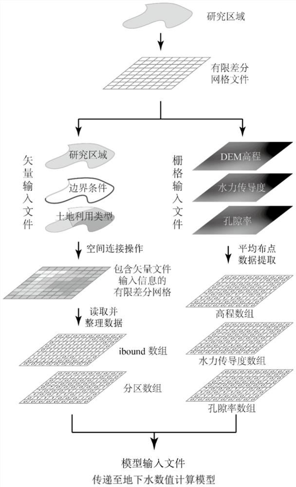
[0057] In the first embodiment, the calculation of the migration law of groundwater and salt in the Yonglian experimental area of ​​the Hetao irrigation area in Inner Mongolia, China is taken as an example for illustration. Such as figure 1 As shown, the nesting method for coupling spatial geographic data and groundwater numerical model provided in this embodiment includes the following steps:

[0058] Step 1. Prepare the regional spatial geographic data file:

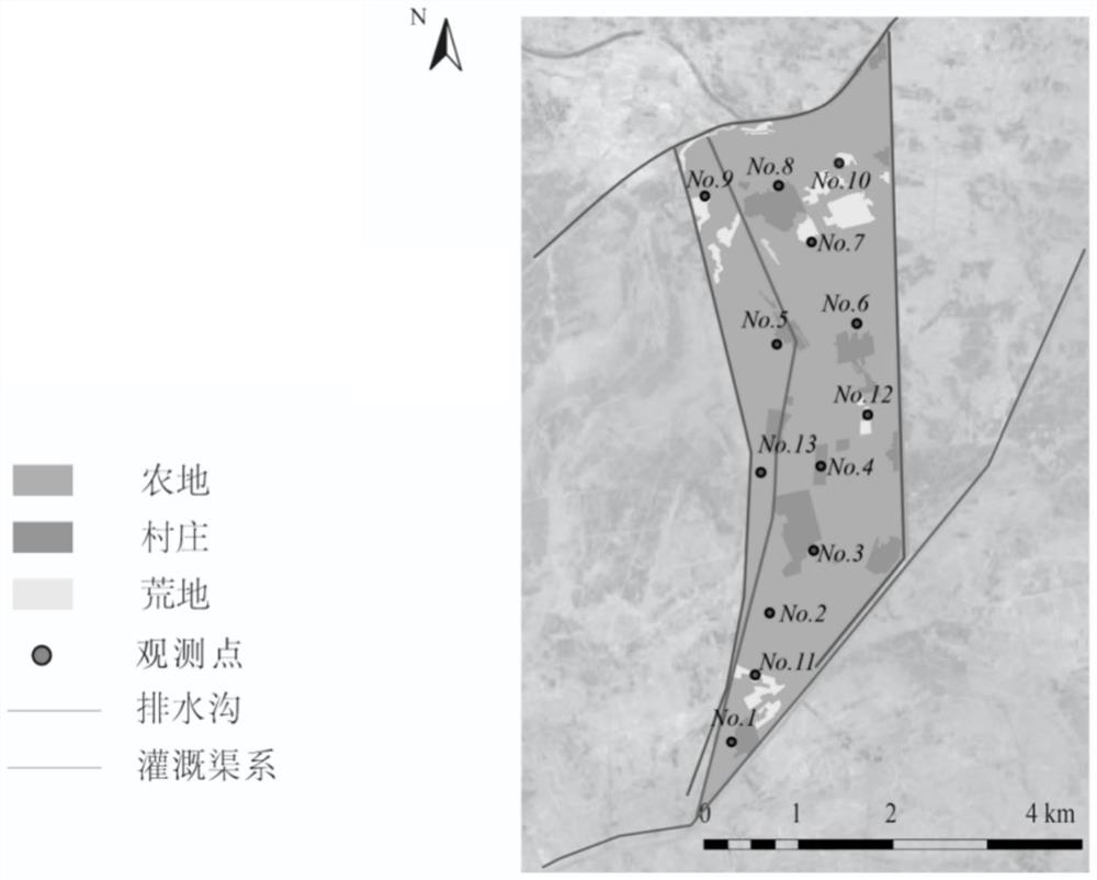
[0059] In this example, the Yonglian experimental area of ​​the Hetao irrigation area in Inner Mongolia is taken as a typical research area, and the geographic location diagram of the Yonglian experimental area is as follows figure 2 shown. The regional spatial geographic data files i...


PUM


Abstract

The invention provides a nested interaction method and device for spatial geographic data and a groundwater numerical model, which can facilitate the rapid processing and operation of the groundwater numerical model for regional complex problems. The method includes: step 1. preparing a regional spatial geographic data file; step 2. performing horizontal finite difference numerical dispersion according to the regional scope; step 3. performing a connection calculation between the vector spatial geographic data and the shapefile file representing the finite difference grid; step 4 .Extract the spatial data information saved in the finite difference grid and organize it into the type required for the groundwater model; Step 5. Extract the grid file information and organize it into the type required for the groundwater model; Step 6. Analyze the time-varying boundary conditions Read and sort to generate the boundary time-varying data type required by the numerical simulation model; Step 7. According to the requirements of the groundwater numerical simulation model for the input file, generate the array file representing the spatial information obtained above into the model input file.

Description

technical field [0001] The invention belongs to the field of groundwater numerical simulation, and in particular relates to a nested interaction method and device for regional spatial geographic data and a groundwater numerical model. [0002] technical background [0003] With the rapid development of computer technology, numerical methods for solving groundwater problems have developed rapidly and become the main technical means to solve regional groundwater problems. Research institutes and colleges and universities at home and abroad have developed a variety of application programs that can be used for regional groundwater numerical calculations, such as determining the diffusion of pollutants, calculating the location and magnitude of land subsidence, the migration process of irrigation water in agricultural irrigation areas and salinity. Good results have been achieved in applications such as the calculation of the accumulation process. [0004] In practical problems, ...

Claims


Application Information

Patent Timeline
Patent Type & Authority Patents(China)
IPC IPC(8): G06F30/23G06T17/05G06F16/29G06F111/10
CPCG06F30/23G06T17/05G06F16/29G06F2111/10
Inventor 朱焱毛威赵天兴杨洋杨金忠伍靖伟
Owner WUHAN UNIV
Why Eureka
Try Eureka