
Beidou satellite navigation signal distortion adaptive compensation method

An adaptive compensation and navigation signal technology, applied in the field of satellite navigation signal processing, can solve the problems of estimation result error, low efficiency, large error, etc., and achieve the effect of improving accuracy and broad application prospects.

Pending Publication Date: 2021-09-14
NAT TIME SERVICE CENT CHINESE ACAD OF SCI
View PDF4 Cites 2 Cited by
  • Summary
  • Abstract
  • Description
  • Claims
  • Application Information

AI Technical Summary

Problems solved by technology

However, the deficiencies of the existing technology are mainly reflected in: first, the traditional predistortion method or optimization compensation method mainly compensates the nonlinear characteristics of the power amplifier, without considering the non-ideal characteristics of the on-board filter and other devices, so the optimization The compensation effect is not very ideal; second, due to various issues such as confidentiality, the structural characteristics of satellite payloads have not been announced to the public, and it is difficult for users to accurately model and analyze the load characteristics. The existing methods are mainly based on satellite signal quality evaluation The analysis of the parameters needs to be optimized and adjusted. The disadvantage of this is that the satellite signal quality evaluation parameters cannot reflect all the performance of the satellite signal. Even if the satellite signal quality evaluation parameters meet the index requirements, the satellite signal received by the user is still possible. There is a large degree of pseudo-range deviation; thirdly, in the existing methods of optimizing compensation for satellite signal pre-distortion, the spectrum analysis method, impulse response method and least square method are mainly used to roughly estimate the channel characteristics of the entire transmission link of the satellite signal, Then roughly deduct the influence of space transmission and reception channels to obtain the characteristics of satellite transmission channels
There are several shortcomings here: the principle of impulse response is relatively simple, but when the input signal contains multiple signal components, this method cannot effectively identify the channel function of the satellite navigation signal; the spectral analysis method is obtained by calculating the spectral density function of the input and output signals The characteristics of the signal transmission channel, however, there is a large error in the estimation result of the integer multiple bandwidth frequency; the batch processing method of the least squares method needs to meet the assumption that the noise type is Gaussian white noise. If the signal is colored noise, the identification method will bring Large error, and this method requires prior information such as various codes of the input signal and power distribution ratio between signals, so for satellite navigation signals containing military signals, it is necessary to analyze the authorized signal first, and at the same time, it needs to meet the requirements during the solution process The input matrix is ​​singular
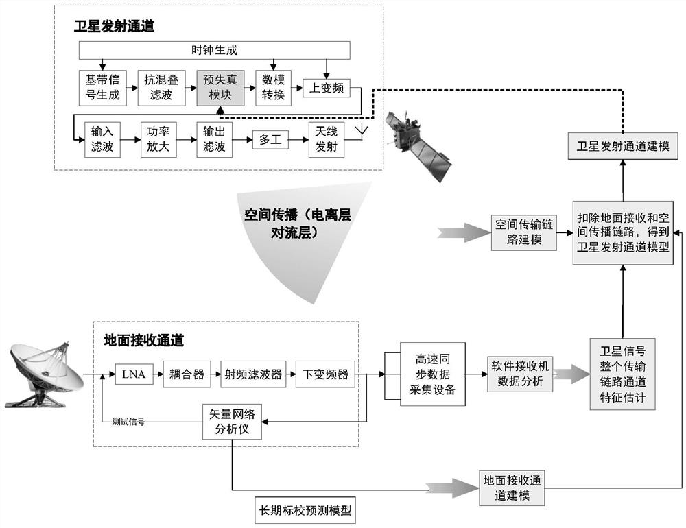
The present invention utilizes the recursive least squares method based on QR decomposition to carry out self-adaptive compensation optimization. Since QR decomposition is used instead of inversion operation, it can not only save cost but also greatly reduce complexity, so the method has fast convergence speed and high precision; in addition, due to ionization The impact of both the ionosphere and the troposphere on the signal cannot be ignored, so when modeling the space transmission link, not only the impact of the ionosphere, but also the impact of the troposphere are taken into account; fourth, when the satellite launch channel characteristics are estimated, it is mainly based on The signal data of a single satellite collected by a large antenna, the main problem here is: the user obtains the positioning results by simultaneously receiving at least 4 satellite signals and performing corresponding differential processing, so even if the downlink of each satellite can be guaranteed The distortion characteristics of the signal do not exceed the requirements of the design index, but since the transmission channels of different satellites cannot be completely consistent, it is still impossible to guarantee the consistency of the signals broadcast by all satellites, which will also bring about the problem of pseudo-range deviation of satellite navigation signals. It has seriously affected the service performance of the satellite navigation system; fifthly, in the existing technology for the on-orbit optimization and maintenance method of the Beidou global system satellites, the pre-distortion module is placed on each satellite. Due to the limited resources on the satellite, it is considered Cost issue, the adjustable range of the parameters of the pre-distortion module is small, and the channel distortion cannot be compensated to the greatest extent
[0005] To sum up, the research on the optimization method of satellite navigation signals by traditional methods or existing methods is still in the exploratory stage, and the optimization effect is not ideal. Characteristics of signal failure Carry out targeted signal performance optimization, let alone realize software automatic processing, so the efficiency is low, and the effect of parameter adjustment is not ideal, which greatly affects the further improvement and optimization of the satellite navigation system PNT performance

Method used


Image

  • Beidou satellite navigation signal distortion adaptive compensation method
  • Beidou satellite navigation signal distortion adaptive compensation method
  • Beidou satellite navigation signal distortion adaptive compensation method

Examples


Embodiment Construction

[0035] The present invention will be further described below in conjunction with the accompanying drawings and embodiments, and the present invention includes but not limited to the following embodiments.

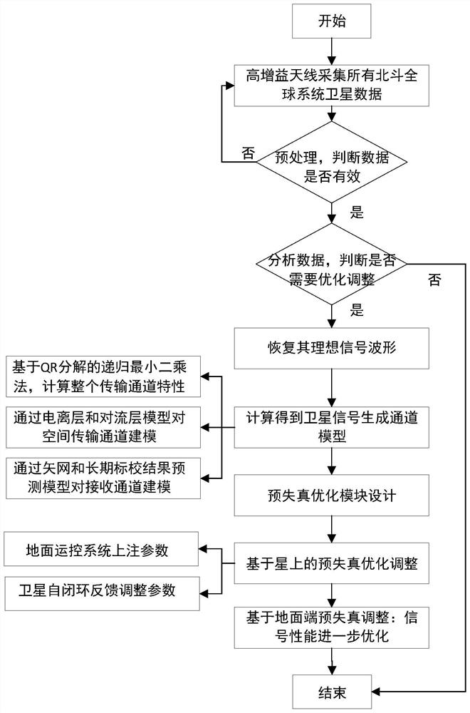
[0036] like figure 1 Shown, the concrete practice of the present invention is as follows:

[0037] (1) First, use a higher-gain antenna (gain greater than 40dBi) to receive downlink navigation signals from BDS-3 satellites, and use high-speed data acquisition equipment to collect satellite signals (for higher-precision offline analysis, the sampling frequency must be greater than or equal to 250MHz, the number of bits is greater than or equal to 12), and stored in the data disk array;

[0038] (2) Then analyze and process the collected data to determine whether optimization and adjustment is needed on the star. This mainly includes two aspects: preprocessing and judging whether the signal needs to be optimized and adjusted: the preprocessing mainly includes data prelimina...


PUM


Abstract

The invention provides a Beidou satellite navigation signal distortion adaptive compensation method. The method comprises the following steps of: recovering a theoretical signal waveform by using acquired data; modeling the characteristics of a satellite signal transmitting channel to obtain a characteristic estimation result of the satellite signal transmitting channel; compensating amplitude characteristics and phase characteristics of the satellite signal transmitting channel to obtain related parameters of an on-satellite pre-distortion filter; and uploading the related parameters of the on-satellite pre-distortion filter to a satellite to complete satellite-based pre-distortion parameter adjustment. According to the method, distortion caused by the signal transmitting channel is compensated by adopting a means of combining on-satellite pre-distortion and ground end pre-distortion technologies, the operation is simple, the method is easy to implement, self-adaptive optimization adjustment of signal performance can be achieved while high signal optimization precision can be guaranteed, and the satellite signal optimization efficiency and credibility are greatly improved.

Description

technical field [0001] The invention belongs to the technical field of satellite navigation signal processing, and in particular relates to a compensation method for satellite navigation signal distortion. Background technique [0002] Global Navigation Satellite System (GNSS, Global Navigation Satellite System) provides positioning, navigation and timing services (PNT, Positioning, Navigation, Timing) to global users by transmitting downlink navigation signals from in-orbit satellites. At present, GNSS has been widely used in many fields related to national economic construction and national security, such as geodesy, engineering surveying, rescue, precision agriculture, earthquake monitoring, geodynamics and other applications, and plays an important role. Among them, the satellite navigation signal is the only interface between the satellite navigation system and the user receiver, and the limit of its intrinsic performance will directly determine the service performance ...

Claims


Application Information

Patent Timeline
Patent Type & Authority Applications(China)
IPC IPC(8): G01S19/20G01S19/37
CPCG01S19/20G01S19/37
Inventor 贺成艳郭际杨倩倩王鹏博郝振圆
Owner NAT TIME SERVICE CENT CHINESE ACAD OF SCI
Learn More