Accessing agriculture productivity and sustainability

a technology of agricultural productivity and sustainability, applied in the field of accessing agriculture productivity and sustainability, can solve the problems of minimal contribution to the total environmental burden at the watershed scale, no consensus on whether net greenhouse gas emissions could be reduced, and great challenges for human beings in maintaining food security. high accuracy, high spatiotemporal resolution

Pending Publication Date: 2022-03-03
THE BOARD OF TRUSTEES OF THE UNIV OF ILLINOIS
View PDF0 Cites 17 Cited by
  • Summary
  • Abstract
  • Description
  • Claims
  • Application Information

AI Technical Summary

Benefits of technology

[0013]According to some aspects, the present disclosure develops an Integrated Multi-scale modeling platform to assess Agricultural Productivity and Sustainability, named “IMAPS”. The IMAPS modeling framework is designed to assess the environmental impacts of agricultural management from individual fields to watershed / basin to continental scales. A scalable and hierarchical discretization (SHD) scheme for surface heterogeneity representation over agricultural landscape is designed for the IMAPS, in which each cropland parcel can be individually represented enabling hyper-resolution simulation. The SFID scheme is then coupled with an advanced agroecosystem model to simulate coupled energy-water-carbon-nutrient cycling processes at sub-field to field scales. Lateral water and nutrient fluxes are either dynamically routed along a ditch-river network derived from high-resolution remote sensing products to the watershed outlets (FIG. 2) or directly routed to the watershed outlets using a data-driven scaling approach. Multi-source observation data, including those from satellite / airborne / proximal remote sensing, wireless sensor network (WSN), Internet of Things (IoT), Eddy-Covariance (EC) flux towers, ground surveys, in-situ field experiments, standard streamflow gauges, and governmental statistical data are integrated within the IMAPS system to constrain the process-based model through a generic model-data fusion framework (FIG. 3). In particular, ubiquitous satellite-derived measurements will be used to constrain model simulation for each field parcel, which will enable the location-specific simulation to achieve high accuracy. Both greenhouse gas (GHG) emissions (carbon footprint) and water quantity / quality (water footprint) are explicitly simulated in the MAPS modeling framework, making it an ideal platform to assess the sustainability and guide the BMP design from field to watershed / basin to continental scales. Scenario and life cycle analysis is used in the IMAPS system to assess changes of both crop productivity and environmental footprint under different agricultural management practices and climate change. A comprehensive computer database is developed to store and archive all the input and output data of the IMAPS modeling platform and a visualization website portal is developed to efficiently communicate the simulation results with users.
[0014]Additional aspects and / or embodiments are provided that include an integrated irrigation system, combining one or more of the following approaches: (1) use of satellite-based BESS-STAIR ET data or CropEyes sensor derived ET data to constrain a hydrological model; (2) once the hydrological model is constrained, both water supply (i.e., soil moisture) and water demand (i.e. vapor pressure deficit) are considered to jointly determine when crop is under water stress and requires irrigation; (3) inclusion of weather forecast for the ET calculation and soil moisture simulation; and (4) if farmers do not provide their irrigation information, use of a model-data fusion method to estimate irrigation timing and amount and thus can continue to provide farmer irrigation information without requesting their data.
[0015]In certain embodiments, the technology (the dynamic precision irrigation scheme) aims to provide precision irrigation scheduling based on plant water stress considering soil moisture and VPD with the operational field-scale ET products and soil moisture from highly constrained hydrologic models. This precision irrigation scheme is water-efficient and can be applied to every individual field in large regions, such as county, state, or nation.
[0016]There are some existing efforts attempted to provide precision irrigation scheduling based on some indexes interpreting plant water stress, such as: maximum allowable depletion (MAD), crop water stress index (CWSI). These processes determine plant water stress focusing on limited aspects and require accurate field-scale observations of soil moisture and / or canopy temperature (satellite observations involving large uncertainty), thus unscalable. In certain embodiments, the process and system (new precision irrigation scheme) use new concepts (supply-demand dynamics among the soil-plant-atmosphere continuum, SPAC) to define plant water stress considering soil moisture and VPD for precision irrigation based on the operational field-scale ET products with high-accuracy.
[0017]Certain embodiments include systems and methods (new precision irrigation scheme) that provide operational field-scale ET products with a high spatiotemporal resolution and define plant water stress considering soil moisture and VPD for precision irrigation. With the operational ET products and new definition of plant water stress for precision irrigation, the precision irrigation process is water-efficient and can be applied at every individual field in large regions, such as county, state, or nation.
[0018]Still further aspects and / or embodiments relate to effective real-time crop cover classification prediction is essential to real-time large-scale crop monitoring. Embodiments of the present disclosure include a system and method that employs a deep-learning-based method to accurately classify crop cover types during the growing season, and continuously refining the classification. In certain embodiments, the method includes three components: a prior-knowledge model, an evolving remote-sensing-based model, and an evolving weight model. Historical planting information is incorporated into the prior-knowledge model to improve the performance, especially in the pre and early season when remote sensing images do not contain distinguishable crop signals. Remote sensing data available on the day of prediction is used by the remote-sensing-based model to extract spatial and temporal information that can be used to classify the crops. The two models are then combined using the weight model, which evolves over time and allows the remote-sensing-based model to be increasingly dominant as more information is available. An effective national acreage model is also developed to aggregate this method's prediction to regional and corn and soybean acreage.

Problems solved by technology

Human beings are facing great challenges in maintaining food security and environmental quality under climate change and land use intensification.
Though the concept of “best management practices” has long been proposed to minimize the environmental impacts of agricultural management, there is still a huge gap towards prescribing best management practices locally at the field scale which minimally contribute to the total environmental burden at the watershed scale.
However, no consensus has been achieved on whether the net greenhouse gas emissions could be reduced by adopting conservation management practices and how large their climate change mitigation potential could be, if there is any.
However, there are still great challenges in accounting and verifying the carbon credit in an accurate and scalable manner.
However, either current land surface models, hydrological models, or crop models are not ideal tools for this exercise.
However, they generally have over-simplified representations of surface heterogeneity using land-cover type based tiling approach, and the impacts from soil heterogeneity and topography are largely neglected in these kind of models as they are mainly developed for large-scale land-atmosphere interaction applications.
However, the current hydrological models seldomly simulate energy balance, carbon and nutrient cycles, as well as crop growth and management practices at the field scale.
However, the landscape impact of crop cultivation can hardly be assessed using agronomy-based crop models due to their lack of representation for either hydrological or biochemical processes and landscape heterogeneity.
Representing heterogeneity over the agricultural landscape is one of the most critical issues when designing an integrated modeling framework.
Study has indicated that hydrographs simulated using channel networks automatically extracted from DEM cannot match with the observed hydrograph in both phase and magnitude at artificially drained agricultural land.
However, the current modeling studies seldom consider the biochemical effects of drainage ditches.
Though some ditch-related conservation practices (such as two-stage ditch and vegetation ditch) have been proposed for nutrient removal, the regional impact of adopting those practices can only be evaluated when the ditch-related processes are represented in the model.
Models are prone to uncertainties from model structure, parameters and input data.
Imperfect input data could also lead to uncertainties in model simulations, such as weather forcing, soil characteristics and initial condition.
Finally, thus far there is no model that can integrate the life-cycle analysis (LCA) to the farm-level information.

Method used


Image

  • Accessing agriculture productivity and sustainability
  • Accessing agriculture productivity and sustainability
  • Accessing agriculture productivity and sustainability

Examples


example 1

ated Multi-Scale Modeling Platform to Assess Agricultural Productivity and Sustainability (IMAPS)

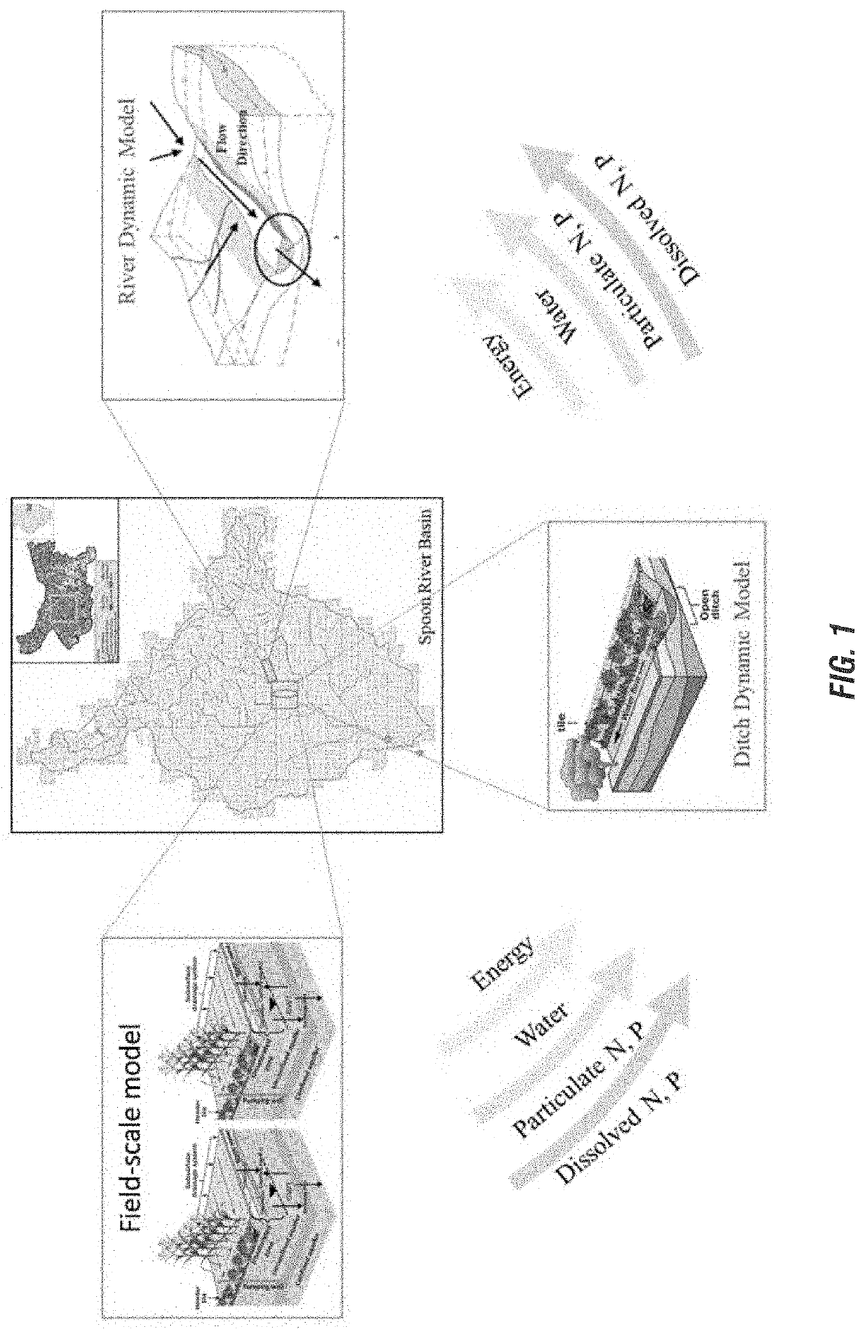
[0105]According to at least some aspects and / or embodiments provided herein, an Integrated Multi-scale modeling platform to assess Agricultural Productivity and Sustainability, named “IMAPS”, is developed and utilized. The IMAPS modeling framework is designed to assess the environmental impacts of agricultural management from individual fields to watershed / basin to continental scales (FIG. 1). A scalable and hierarchical discretization (SHD) scheme for surface heterogeneity representation over agricultural landscape is designed for the IMAPS, in which each cropland parcel can be individually represented enabling hyper-resolution simulation. The SHD scheme is then coupled with an advanced agroecosystem model to simulate coupled energy-water-carbon-nutrient cycling processes at sub-field to field scales. Lateral water and nutrient fluxes are either dynamically routed along a ditch-river ne...

example 2

e and Cost-Effective Precision Irrigation Scheme with Field-Scale ET Products Based on Supply-Demand Dynamics

[0146]Field-scale evapotranspiration (ET) and soil moisture are critical for precision irrigation at fine scales. The most widely used approach for irrigation scheduling (i.e., when and how much water to irrigate) is solely based on soil moisture, which is usually estimated from soil water balance with crop water use (i.e., ET). ET is usually obtained from coarse-resolution satellite ET products and / or using Penman-Monteith equation and the crop coefficients with the meteorological data from nearby weather stations, while soil moisture is usually provided by soil water balance and / or soil moisture sensors directly. However, the traditional approaches for field-scale ET and soil moisture for irrigation scheduling is expensive and / or sometimes low-accuracy.

[0147]Furthermore, soil moisture deficit and atmospheric aridity (high vapor pressure deficit, VPD) both can cause reductio...

example 3

of Generating and Refining Crop Types Classification and Acreage Forecast During the Crop Growing Season (BlueBird)

[0175]An effective real-time crop cover classification prediction is essential to real-time large-scale crop monitoring. High resolution satellite optical data containing distinguishable signals of different crop types have been used by recent crop cover classification studies. However, existing works that merely use satellite information fail to reach a high accuracy, especially in the early growing season (e.g., before July) because of lacking informative satellite scenes that can be used to effectively distinguish crops. In this section, what is presented is a deep-learning-based method, herein named BlueBird, to accurately classify crop cover types in real-time at the national scale. BlueBird consists of three sub-models: prior-knowledge model, real-time optical model, and real-time weight model. Historical planting information, sequence of planted crop types in pas...


PUM


Abstract

An integrated multi-scale modeling platform is utilized to assess agricultural productivity and sustainability. The model is used to assess the environmental impacts of agricultural management from individual fields to watershed/basin to continental scales. In addition, an integrated irrigation system is developed using data and a machine-learning model that includes weather forecast and soil moisture simulation to determine an irrigation amount for farmers. Next, crop cover classification prediction can be established for an ongoing growing system using a machine learning or statistical model to predict the planted crop type in an area. Finally, a method of predicting key phenology dates of crops for individual field parcels, farms, or parts of a field parcel, in a growing season, can be established.

Description

CROSS-REFERENCE TO RELATED APPLICATIONS[0001]This application claims priority under 35 U.S.C. § 119 to provisional patent application U.S. Ser. No. 63 / 070,250, filed Aug. 25, 2020. The provisional patent application is herein incorporated by reference in its entirety, including without limitation, the specification, claims, and abstract, as well as any figures, tables, appendices, or drawings thereof.STATEMENT AS TO FEDERALLY SPONSORED RESEARCH[0002]This invention was made with government support under 1847334 awarded by the National Science Foundation, under 2019-67021-29312 awarded by the United States Department of Agriculture / National Institute of Food and Agriculture and under DE-SC0018420 awarded by the Department of Energy. The government has certain rights in the invention.FIELD OF THE INVENTION[0003]Aspects and / or embodiments of the disclosure are directed towards systems and / or methods for an integrated multi-scale modeling platform to assess agricultural productivity and ...

Claims


Application Information

Patent Timeline
Patent Type & Authority Applications(United States)
IPC IPC(8): A01G25/16A01B79/00G06N20/00
CPCA01G25/16G06N20/00A01B79/005G06N3/084A01G7/00Y02A40/22A01B69/001G06N3/044
Inventor GUAN, KAIYUPENG, BINJIANG, CHONGYAZHOU, WANGZHANG, JINGWENHUANG, YIZHIPENG, JIANWANG, SIBO
Owner THE BOARD OF TRUSTEES OF THE UNIV OF ILLINOIS
Why Eureka
Try Eureka