Short range spread-spectrum radiolocation system and method

a radiolocation system and short-range technology, applied in the field of radiolocation, can solve the problems of deteriorating gps accuracy, large gps receiving hardware, and inability to meet the needs of mass implementation applications,

Inactive Publication Date: 2003-04-29
UT BATTELLE LLC
View PDF23 Cites 227 Cited by
  • Summary
  • Abstract
  • Description
  • Claims
  • Application Information

AI Technical Summary

Benefits of technology

A system, representing an embodiment of the invention, can be cost effective and advantageous for at least the following reasons. The invention provides a low-cost radiolocation system that provides sufficient gross ranging, with unambiguous intermediate and fine ranging resolution for greater accuracy. The invention provides a radiolocation system where tags for unattended assets can be manufactured with as many components as possible on a single integrated-circuit (IC) chip, for low cost, small size, low power, high reliability, and good repeatability.All the disclosed embodiments of the invention described herein can be realized and practiced without undue experimentation. Although the best mode of carrying out the invention contemplated by the inventors is disclosed above, practice of the invention is not limited thereto. Accordingly, it will be appreciated by those skilled in the art that the invention may be practiced otherwise than as specifically described herein.For example, the individual components need not be formed in the disclosed shapes, or assembled in the disclosed configuration, but could be provided in virtually any shape, and assembled in virtually any configuration. Further, the individual components need not be fabricated from the disclosed materials,.but could be fabricated from virtually any suitable materials. Further, although the tag described herein can be a physically separate module, it will be manifest that the tag may be integrated into the apparatus with which it is associated. Furthermore, all the disclosed elements and features of each disclosed embodiment can be combined with, or substituted for, the disclosed-elements and features of every other disclosed embodiment except where such elements or features are mutually exclusive.It will be manifest that various additions, modifications and rearrangements of the features of the invention may be made without deviating from the spirit and scope of the underlying inventive concept. It is intended that the scope of the invention as defined by the appended claims and their equivalents cover all such additions, modifications, and rearrangements.The appended claims are not to be interpreted as including means-plus-function limitations, unless such a limitation is explicitly recited in a given claim using the phrase "means for." Expedient embodiments of the invention are differentiated by the appended subclaims.

Problems solved by technology

The GPS generally has poor coverage inside buildings, under forest canopies or heavy foliage, or in highly developed urban areas where tall structures dominate.
Multi-path effects of the radio signals from the satellites seriously deteriorate GPS accuracy in situations involving tall structures such as skyscrapers.
Furthermore, known GPS receiving hardware is currently too large and costly for mass implementation applications, for example, where there is a need for identifying and locating unattended assets such as an item of equipment, a pallet or container of goods, a vehicle, etc.
Although GPS radiolocation is proven and works well, it requires multiple readings to obtain positioning accuracy down to the 10-meter range, which leads to greater complexity in the receiver and longer computation time to calculate a navigational "fix".
Costly military receivers are not hampered by these limitations, but commercial receivers do not have the special encryption features required for rapid high-accuracy location determination, although recent advances in signal processing have somewhat improved the situation.
GPS does not readily adapt to situations where a central locating system is required for locating unattended assets or personnel that cannot respond by transmitting the GPS-determined location information to the central locating system via separate communication means.
For these reasons, GPS is generally not suitable for radiolocation in a limited space at low cost for unattended assets.
Furthermore, due to the extremely low signal strengths of the GPS satellite beacon transmitters at the GPS receiver, GPS signals are virtually always unusable indoors because of the additional attenuation of the overhead satellite signals by building roofs, upper-floors, and other overhead structures, as well as trees and dense foliage in general.
In addition, in "urban canyons" and very rugged terrain, often there are too few GPS satellites in direct line-of-sight view of the receiver to obtain a sufficiently accurate position fix.
In this system, the tags do not include sophisticated circuitry and software for decoding a signal received from a satellite.
One particular drawback of the PinPoint system is that the tags, being predominantly passive transponders, only emit about one milliwatt of RF power, so that the tag can only be detected reliably up to a range of about 30 meters.
This greatly limits the size of the area in which the system is operative, and requires a multiplicity of receivers if greater coverage is desired, thereby adding to the cost and complexity of the system.
This scheme thus requires two discrete RF systems, one for each band, which increases the likelihood of interference and requires the simultaneous use of (and "ties up") two unlicensed radio transmission bands in the local area.
Furthermore, the relative complexity of the PinPoint tag is high, due to the requirement for RF hardware in two widely separated bands.
Although this technique is suitable for providing larger total range readings than with the polynomial code by itself, Dixon does not even suggest how to provide any finer measurement resolution.
There is also still a need for a more limited-scale radiolocation system for applications where the expense and complexity of GPS cannot be justified, or where or the technical limitations of GPS are a problem, such as in forest areas, cities with tall buildings, industrial settings, underground, and the like.

Method used


Image

  • Short range spread-spectrum radiolocation system and method
  • Short range spread-spectrum radiolocation system and method
  • Short range spread-spectrum radiolocation system and method

Examples


Embodiment Construction

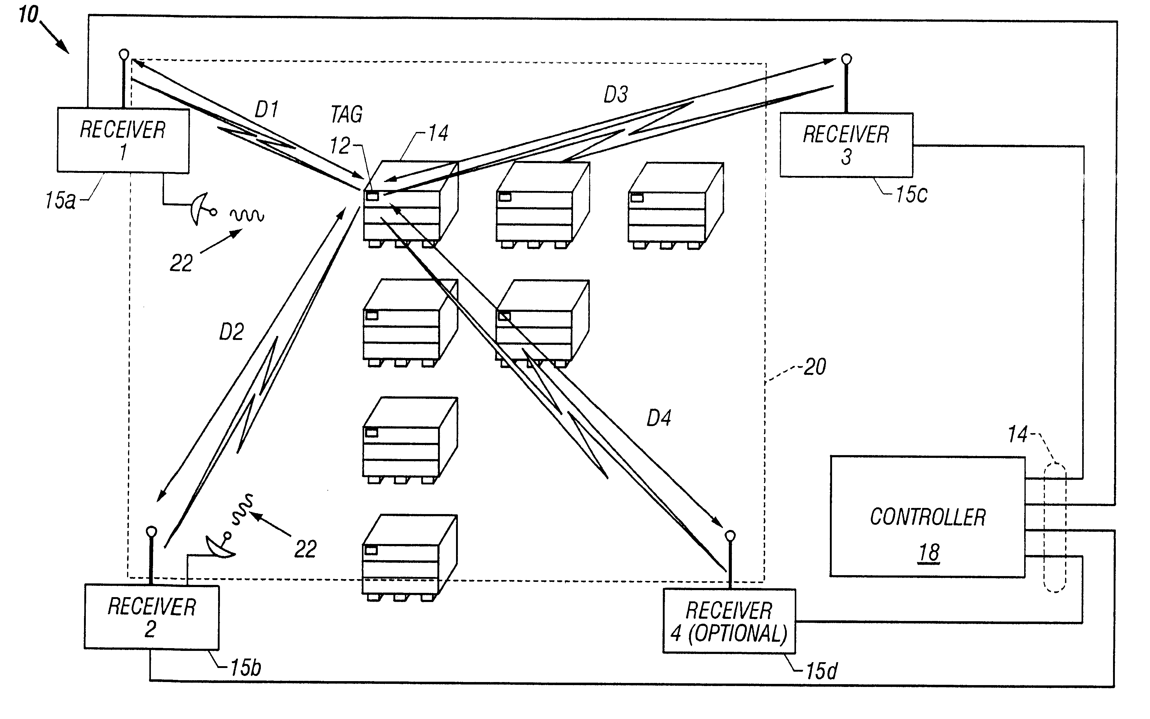
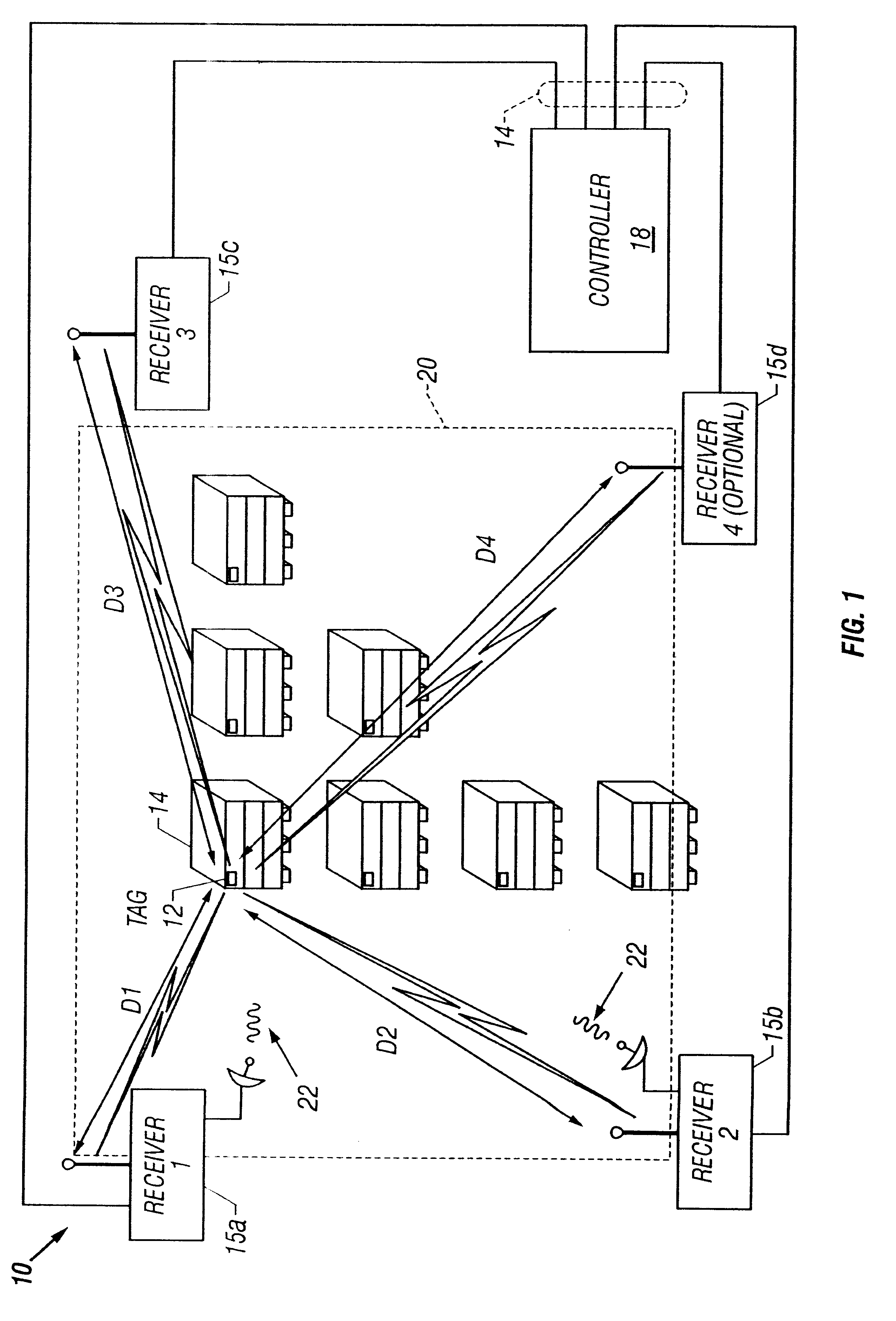
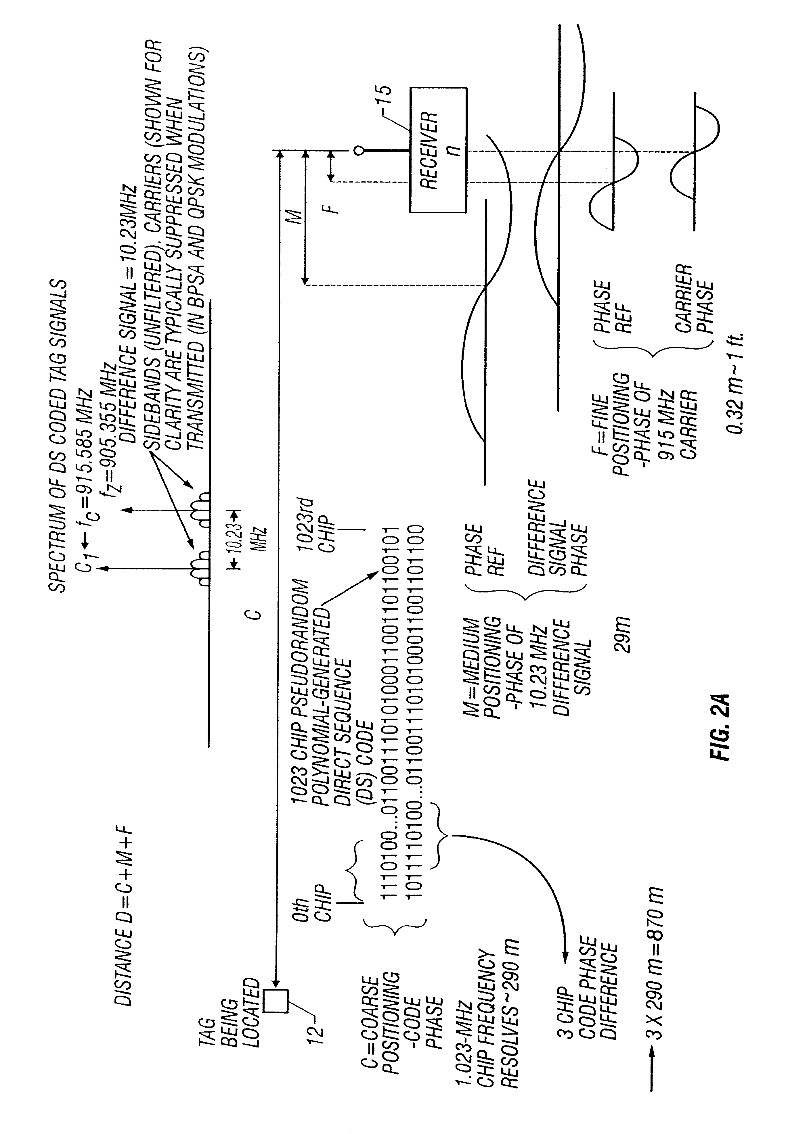
The invention and the various features and advantageous details thereof are explained more fully with reference to the nonlimiting embodiments that are illustrated in the accompanying drawings and detailed in the following description. Descriptions of well known components and processing techniques are generally omitted so as not to unnecessarily obscure the invention in detail.

Within this application several publications are referenced by superscripts composed of Arabic numerals within parentheses. Full citations for these publications may be found at the end of the specification immediately preceding the claims after the section heading References. The disclosures of all these publications in their entireties are hereby expressly incorporated by reference herein for the purpose of indicating the background of the invention and illustrating the state of the art.

The below-referenced U.S. Patents disclose embodiments that were satisfactory for the purposes for which they are intended...


PUM


Abstract

A short range radiolocation system and associated methods that allow the location of an item, such as equipment, containers, pallets, vehicles, or personnel, within a defined area. A small, battery powered, self-contained tag is provided to an item to be located. The tag includes a spread-spectrum transmitter that transmits a spread-spectrum code and identification information. A plurality of receivers positioned about the area receive signals from a transmitting tag. The position of the tag, and hence the item, is located by triangulation. The system employs three different ranging techniques for providing coarse, intermediate, and fine spatial position resolution. Coarse positioning information is provided by use of direct-sequence code phase transmitted as a spread-spectrum signal. Intermediate positioning information is provided by the use of a difference signal transmitted with the direct-sequence spread-spectrum code. Fine positioning information is provided by use of carrier phase measurements. An algorithm is employed to combine the three data sets to provide accurate location measurements.

Description

1. Field of the InventionThe invention relates generally to radiolocation, and more particularly relates to a short-range radiolocation system suitable for smaller areas, indoor applications, and cost-critical products such as asset and personnel tags for providing high accuracy position data for situations where Global Positioning Satellite (GPS) systems are either ineffective or too expensive.2. Discussion of the Related ArtThe Global Positioning System (GPS) is a satellite-based navigation system known to be of great utility in many wide-area, outdoor scenarios, particularly in military and commercial navigational applications. This system lets a user with a GPS receiver determine his or her location on the earth with a high degree of accuracy, based on signals received from satellites orbiting the earth. Although this system was developed primarily for military use by the United States Department of Defense, civilian uses have exploded in recent years.In certain navigational and...

Claims


Application Information

Patent Timeline
Patent Type & Authority Patents(United States)
IPC IPC(8): G01S11/02G01S11/00G01S1/00G01S1/06G01S5/14G01S19/11
CPCG01C21/206G01S11/02G01S5/14G01S1/06
Inventor SMITH, STEPHEN F.
Owner UT BATTELLE LLC
Why Eureka
Try Eureka