However, these wireless E-911 calls do not get the same quality of emergency assistance that fixed-network E-911 calls enjoy.
Cellular phone fraud has attained a notorious level, which serves to increase the usage and operation costs of cellular networks.
Furthermore, cellular fraud weakens the
consumer confidence in wireless services.
(a) The
server broadcasts a
list of all
GPS satellites in view of handsets within its vicinity, along with the relative Doppler offset of each
satellite. Such information can help reduce the time and accuracy of the MS measurement. For example, a regular
GPS receiver can take up to several minutes to lock onto
GPS satellites in site, while it takes a few seconds to estimate the
satellite signal parameters. Thus, in a
server-aided
scenario, the time and power needed by the MS to estimate the GPS
satellite signal parameters are dramatically reduced.
(b) If the
server has access to
terrain altitude
database, it can provide this information to the MS. This reduces the number of unknown parameters to three instead of four, which translates to a higher location accuracy if four satellite measurements are available.
(c) The server node can contain a reference
GPS receiver, with an antenna at a precisely known location and a
clock of a similar accuracy to that of the satellites. This reference
GPS receiver estimates certain parameters of the GPS satellite signals and then broadcasts this data in the form of aiding data (or corrections) to all mobile stations in its vicinity. This correction data can be exploited by the MS to increase its location
estimation accuracy. This technique is generally known as
Differential GPS (DGPS). The aiding data can include correction data for multipath and reflection effects, satellite 50 Hz data, atmospheric delays, and any deliberate error enforced by the GPS
satellite network. These corrections become less accurate with increasing distance between the MS and the server as well as with increasing period between consecutive server correction broadcasts.
(d) Finally, the server uses the MS satellite estimated parameters to determine the MS location and then conveys this information to the public safety answering point (PSAP) that requested the location information.
This increases the average distance between the MS and the server leading to ineffective correction information.
Despite these advantages, wireless service providers may be unwilling to embrace GPS fully as the principal
location technology due to the following disadvantages of GPS-based
location systems:
(a) Embedding a GPS
receiver in the mobile
handset directly leads to increased cost, size, and battery consumption of the mobile
handset.
This will directly
impact the rates the wireless carriers offer their users and can cause considerable inconvenience to both users and carriers during the replacement period.
(d) The need for handsets to support both server-aided and pure GPS
modes of operation, which increases the average cost, complexity and
power consumption of the mobile
handset.
Furthermore, the
power consumption of the handset can increase dramatically when used in the pure GPS mode.
Moreover, the need to deploy GPS aiding servers in wireless base stations adds up to the total cost of GPS-aided
location systems.
(e) GPS-based
location systems face a political issue raised by the fact that the GPS
satellite network is controlled by the U.S. government, which reserves the right to shut
GPS signals off to any given region worldwide.
Although this approach, which is also known as forward link wireless location, avoids the need for GPS technology, it has the same disadvantages that GPS location systems have, which is the need to modify existing handsets, and may even have increased handset
power consumption over that of the GPS solution. n addition, this solution leads to lower location accuracy than that of the GPS solution.
This makes cellular mobile-based location systems less favorable to use by wireless service providers.
The main
disadvantage of network-based wireless location is its relatively lower accuracy, when compared to GPS-based location methods.
And, unlike GPS location systems, many aspects of network-based location are not fully studied yet.
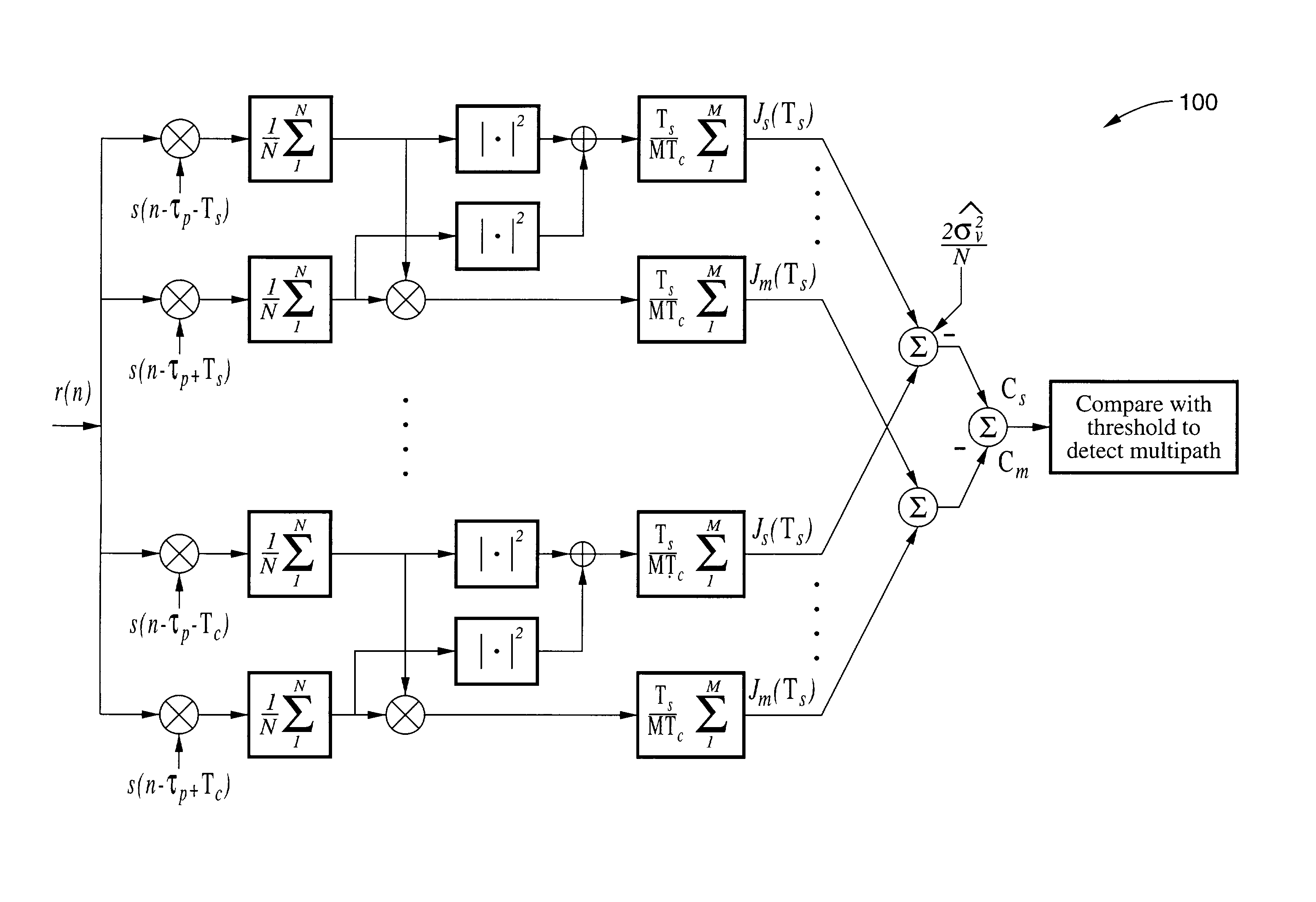
It is clear, however, that
multipath propagation is one of the main sources of mobile-positioning errors, especially in fast channel
fading situations.
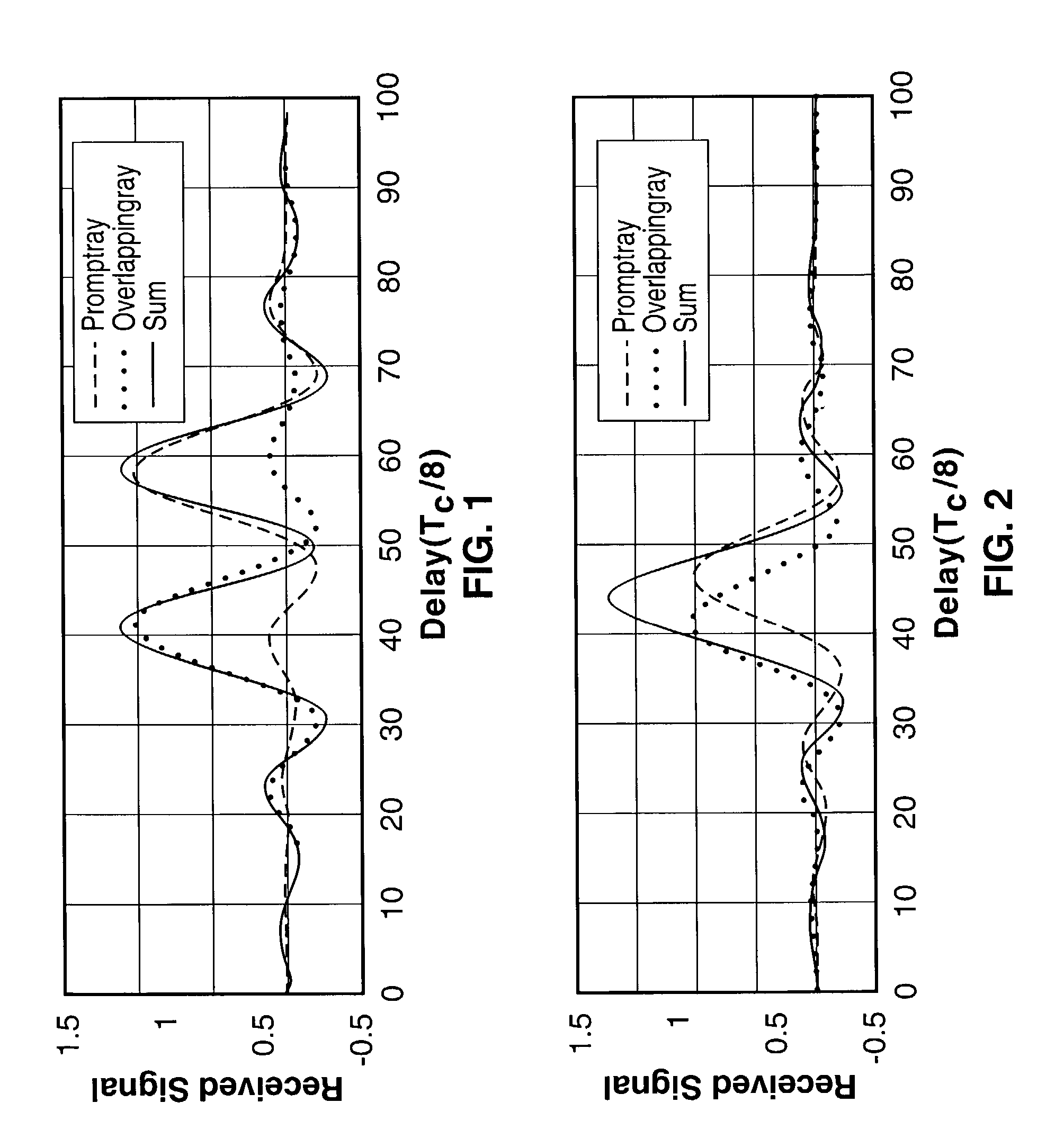
However, wireless propagation usually suffers from severe multipath conditions.
If this
delay is smaller than the duration of the pulse-shape used in the wireless
system (e.g., the
chip duration, Tc, in
CDMA systems), these two rays will overlap and thereby cause significant errors in the prompt
ray time and amplitude of arrival
estimation.
Resolving these overlapping multipath components using known technology becomes impossible in low
signal-
noise-ratio and fast channel fading situations, which are common in
wireless systems.
However, in FIG. 2, both multipath components overlap and are nonresolvable by means of a peak-picking procedure.
This can lead to significant errors in the prompt
ray time and amplitude of arrival
estimation.
In situations where the prompt
ray overlaps with a successive ray, a huge error in both the time and amplitude of arrival is encountered.
Such errors significantly increase when the time
delay between the prompt and successive rays is decreased with respect to the period of the used pulse-shape.
These errors in the time and amplitude of arrival are unacceptable in wireless-location finding applications.
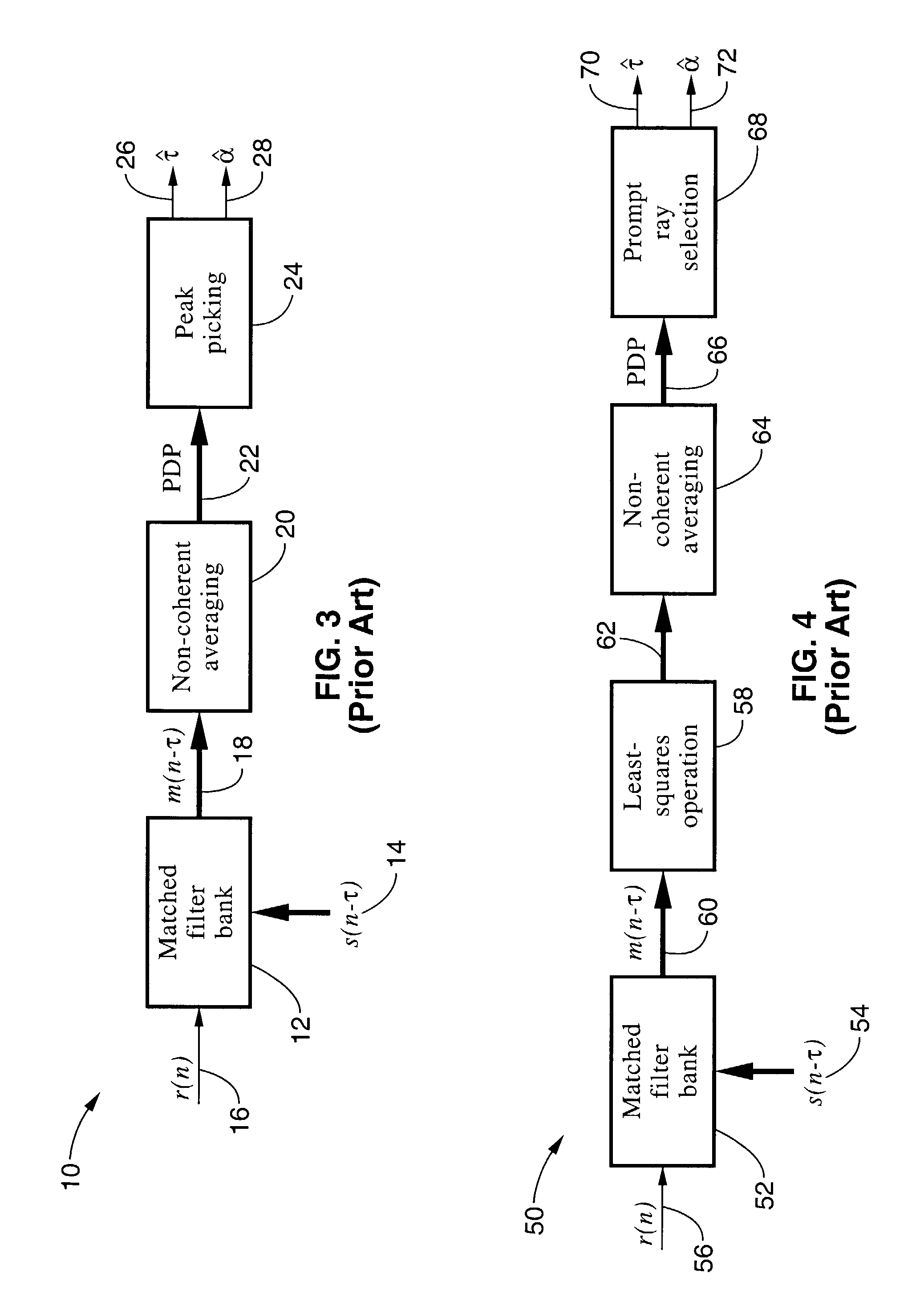
The LS techniques mainly suffer from
noise boosting, which is caused by the ill-conditioning of the matrices involved in the LS operation, especially in fading conditions that prohibit long averaging intervals.
This ill conditioning magnifies the noise at the output of the LS stage.
For wireless-location finding applications, where the received
signal to noise ratio (SNR) is relatively low, noise
magnification leads to huge errors in the time and amplitude of arrival estimates, which results in a very low location precision.
In addition, applying least-squares methods can produce unnecessary errors in the case of single-path propagation.
However, if a least-squares stage is then used, this accuracy can be significantly degraded.

