
Precise orbit determination method of navigation satellite for assisting clock error between stations

A technology for precise orbit determination of navigation satellites, applied in the field of precise orbit determination of navigation satellites, can solve the problems of limited geometric factors of satellite orbit measurement, no configuration of high-precision time synchronization system, no atomic clock, etc., to solve cycle slip detection and Repair, improve the accuracy of orbit determination and prediction, and improve the effect of generalized geometric factors

Inactive Publication Date: 2012-10-24
NAT TIME SERVICE CENT CHINESE ACAD OF SCI
View PDF2 Cites 1 Cited by
  • Summary
  • Abstract
  • Description
  • Claims
  • Application Information

AI Technical Summary

Problems solved by technology

[0003] Insufficient measurement methods and orbit determination data processing methods in the IGS system: IGS stations are not equipped with high-precision time synchronization systems, and most stations are not equipped with atomic clocks
This method mainly has two problems: (1) For the observation of MEO satellites, in the case of regional deployment, the geometric factor is not good, and the observation arc is limited, thus affecting the accuracy of orbit determination; (2) For the observation of GEO satellites , the geometric factor is not good, and because the satellite is relatively stationary, it is difficult to separate the orbit from the clock error, thus affecting the accuracy of orbit determination
[0004] Therefore, in the case of the regional tracking network of IGS mode, the geometric factors of satellite orbit measurement are limited, which affects the accuracy of orbit determination
Especially for geostationary orbit satellites (GEO satellites), in the process of orbit determination, not only the geometric factor is limited, but also the clock error and the orbit are difficult to separate, so it is difficult to achieve precise satellite orbit determination

Method used


Image

  • Precise orbit determination method of navigation satellite for assisting clock error between stations
  • Precise orbit determination method of navigation satellite for assisting clock error between stations
  • Precise orbit determination method of navigation satellite for assisting clock error between stations

Examples


Embodiment Construction

[0050] Now in conjunction with embodiment, accompanying drawing, the present invention will be further described:

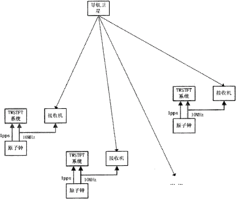
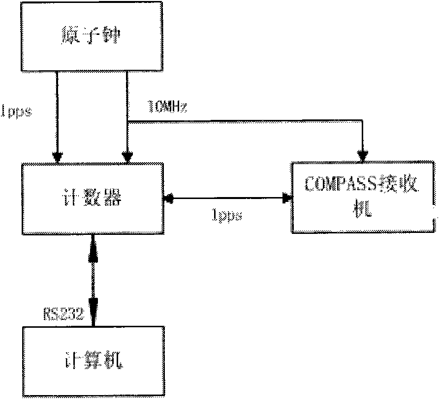
[0051] Relying on the retransmission orbit measurement network (orbit measurement to communication satellites) of the National Time Service Center of the Chinese Academy of Sciences, the domestic orbit measurement network (5 stations) of the COMPASS satellite navigation system is set up, and the method of the present invention is used to carry out the MEO satellite orbit determination test of COMPASS. The test results show that the accuracy of satellite orbit determination and orbit prediction can be effectively improved when each orbit measuring station is equipped with an atomic clock and a two-way satellite time-frequency transmission system.

[0052] Establish 5 orbit measurement stations, located in Lintong (National Time Service Center), Shanghai, Changchun, Kunming and Urumqi respectively, forming a domestic orbit measurement network. In addition to geodes...


PUM


Abstract

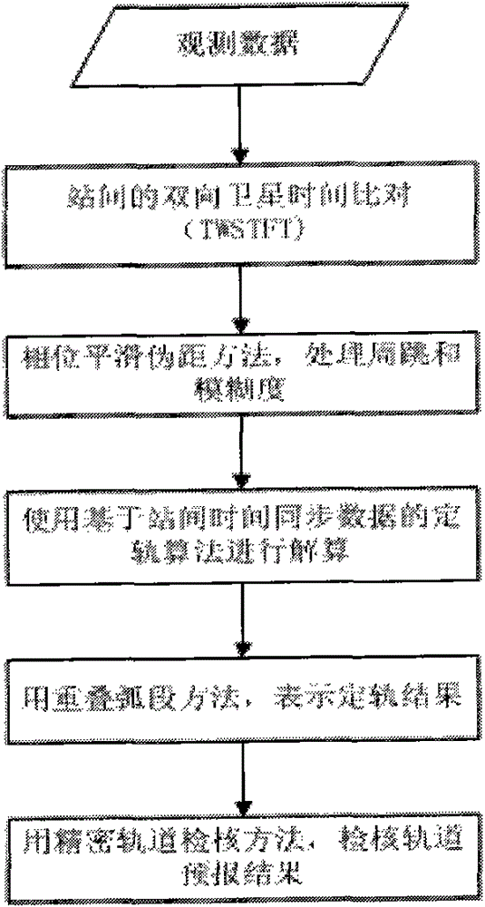
The invention relates to a precise orbit determination method of a navigation satellite for assisting a clock error between stations, which is characterized by comprising the following steps: configuring an atomic clock and a nanosecond stage time synchronization system at each station of an area network, receiving a distance measurement signal of a navigation satellite by each station of the area network to obtain the carrier phase data of each station, detecting the periodic trip generation moment of the carrier phase data by a Blewitt method and carrying out time synchronization between the stations by a two-way satellite time frequency transmission method TWSTFT to obtain a clock error between the stations; resolving a differential equation under an inertial coordinate system to obtain an orbit of the navigation satellite. Before orbit determination data are processed, the method firstly realizes the time synchronization between the stations with high accuracy (i.e.: obtaining theclock error between the stations). During the processing of the orbit determination data, an improved non-error method is adopted, only the orbit needs to be resolved, and the clock error between thestations does not need to be resolved, which not only can improve geometrical factors but also is beneficial to separating a system error (the clock error between the stations). Thus, the orbit determination accuracy can be enhanced.

Description

technical field [0001] The invention relates to a method for precise orbit determination of navigation satellites assisted by inter-station clock differences, relates to the field of precise orbit determination of navigation satellites, and belongs to the disciplines of astrometry and celestial mechanics. Background technique [0002] Introduction to IGS: The emergence and successful operation of IGS have greatly promoted the application of GPS technology in various fields, promoted the development of scientific research worldwide and the improvement of social production and living standards. IGS collects, organizes, and releases high-precision GNSS data to meet the requirements of a wide range of applications and scientific experiments. Precise satellite ephemeris is one of the two core products provided by IGS. The current IGS orbit determination accuracy reaches 5cm (the orbit difference between each analysis center). The IGS station layout mode is to arrange many statio...

Claims


Application Information

Patent Timeline
Patent Type & Authority Patents(China)
IPC IPC(8): G01S19/39
Inventor 杨旭海李志刚雷辉胡小工贾小林弓剑军李伟超吴风雷
Owner NAT TIME SERVICE CENT CHINESE ACAD OF SCI
Learn More