
Establishment method of satellite navigation system level open source simulation system

A satellite navigation system and simulation system technology, which is applied to the establishment of a satellite navigation system-level open source simulation system, can solve the problems of relatively high software scalability, high code complexity, poor development flexibility, etc., and achieves a flexible simulation scheduling mechanism. The effect of clear logic structure and reduced development difficulty

Active Publication Date: 2018-04-06
NAT UNIV OF DEFENSE TECH
View PDF4 Cites 0 Cited by
  • Summary
  • Abstract
  • Description
  • Claims
  • Application Information

AI Technical Summary

Problems solved by technology

[0004] 1. The existing architecture structure is closed, the development flexibility is poor, the code complexity is high, the openness is not enough, and it is not convenient for open source and collaborative development
[0005] 2. Satellite navigation applications are changing with each passing day, and the scalability requirements for related software are relatively high, and the existing architecture technology is not enough to meet the needs
[0007] 4. The existing architecture technology does not consider the concept of the model system, and cannot solve the problem of the complex model system of the satellite navigation system
[0008] 5. The coupling between view logic and business logic is high, the dependencies between functional modules are strong, the logical structure is not clear enough, and a stable and reliable architecture core has not been formed
[0009] To sum up, the existing application software framework adopts the "view + logic" structure, and its structure is closed to the outside world, which is not conducive to the expansion of the framework and has poor flexibility. The commonly used event-driven method increases the complexity of the code, which can Poor maintainability and difficult development and testing. Combining the above shortcomings, it is not conducive to the construction of open source architecture

Method used


Image

  • Establishment method of satellite navigation system level open source simulation system
  • Establishment method of satellite navigation system level open source simulation system
  • Establishment method of satellite navigation system level open source simulation system

Examples


Embodiment Construction

[0041] The present invention will be further described in detail below in conjunction with the accompanying drawings and specific embodiments.

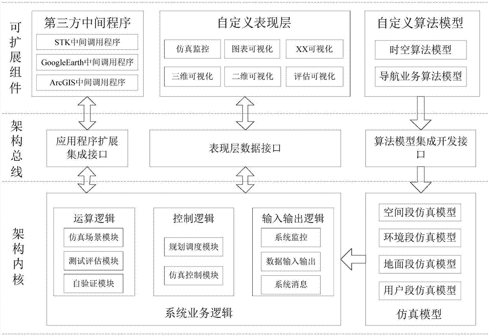
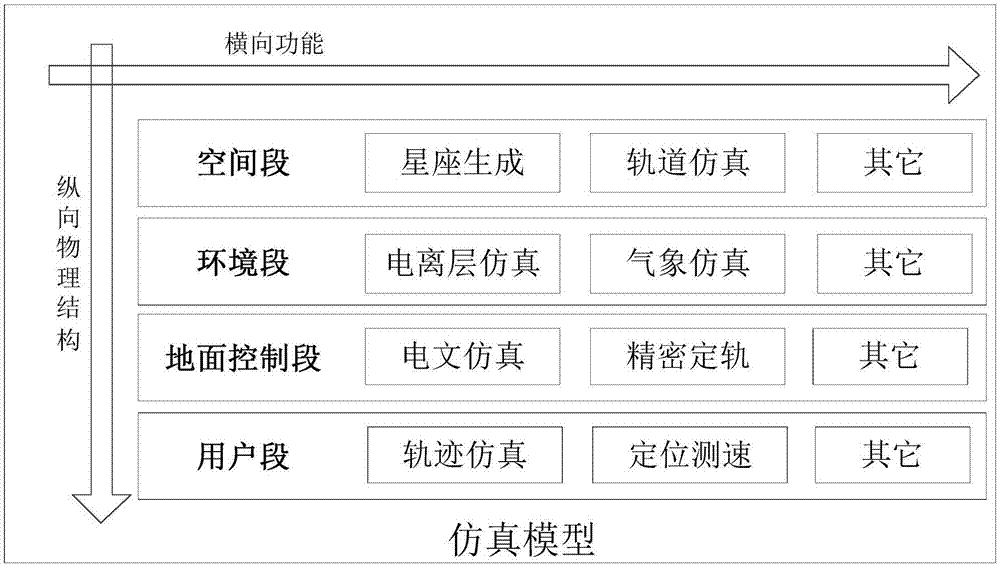
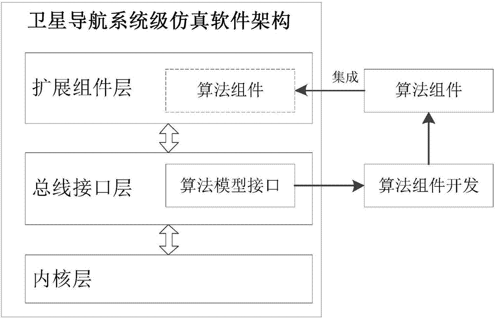
[0042] like figure 1 Shown, the establishment method of satellite navigation system level open source simulation system of the present invention, its steps are:

[0043] S1: Based on the purpose of open source, combined with the characteristics of the satellite navigation system and the technical characteristics of the existing architecture, determine the architecture design idea of ​​"kernel + bus interface + expansion components":

[0044] According to the design idea of ​​satellite navigation system-level open source software architecture, this architecture must be easy to open source and open, and can realize the purpose of multi-person online development and testing on the open source platform. To this end, the design of the system architecture follows the principle of openness and closure, and the external expansion components ...


PUM


Abstract

A method for establishing a satellite navigation system-level open source simulation system comprises a step S1 of determining a 'kernel + bus interface + extension module' system structure by combination with characteristics of a satellite navigation system and technical characteristics of an existing architecture based on the goal of an open source; a step S2 of setting a kernel structure according to high integration packaging thought; a step S3 of carding a composition structure of a satellite navigation simulation system and relevant functions, and establishing a matrix type satellite navigation simulation model system; a step S4 of developing an algorithm model module according to function requirements which the simulation model needs to implement, and dynamically integrating the algorithm model module into the simulation model; a step S5 of developing a universal third-party application program plug-in interface model according to system expansibility, integrating calling logic of a third-party application program plug-in into service logic, and implementing plug and play; and a step S6 of developing presentation layer contents according to satellite navigation system simulation testing and evaluation requirements. The method has the advantages of being high in reusability, scalability and maintainability and open source characteristics.

Description

technical field [0001] The invention mainly relates to the field of satellite navigation systems, in particular to a method for establishing a satellite navigation system-level open-source simulation system suitable for global satellite navigation simulation software system architecture design and model development integration technology. Background technique [0002] The global satellite navigation system is a complex navigation and positioning system composed of space segment, environment segment, ground segment and user segment. The whole process involves many disciplines such as time and coordinates, orbital attitude, measurement and communication, positioning and evaluation, etc. It is a kind of model and data, with complex system composition and control management characteristics. As the global satellite navigation system is widely used, the satellite navigation system has become a symbol of comprehensive national strength, but there is no relatively mature method for ...

Claims


Application Information

Patent Timeline
Patent Type & Authority Patents(China)
IPC IPC(8): G06F17/50
CPCG06F30/20
Inventor 杨俊黄文德李靖郭熙业胡梅康娟张利云
Owner NAT UNIV OF DEFENSE TECH
Learn More