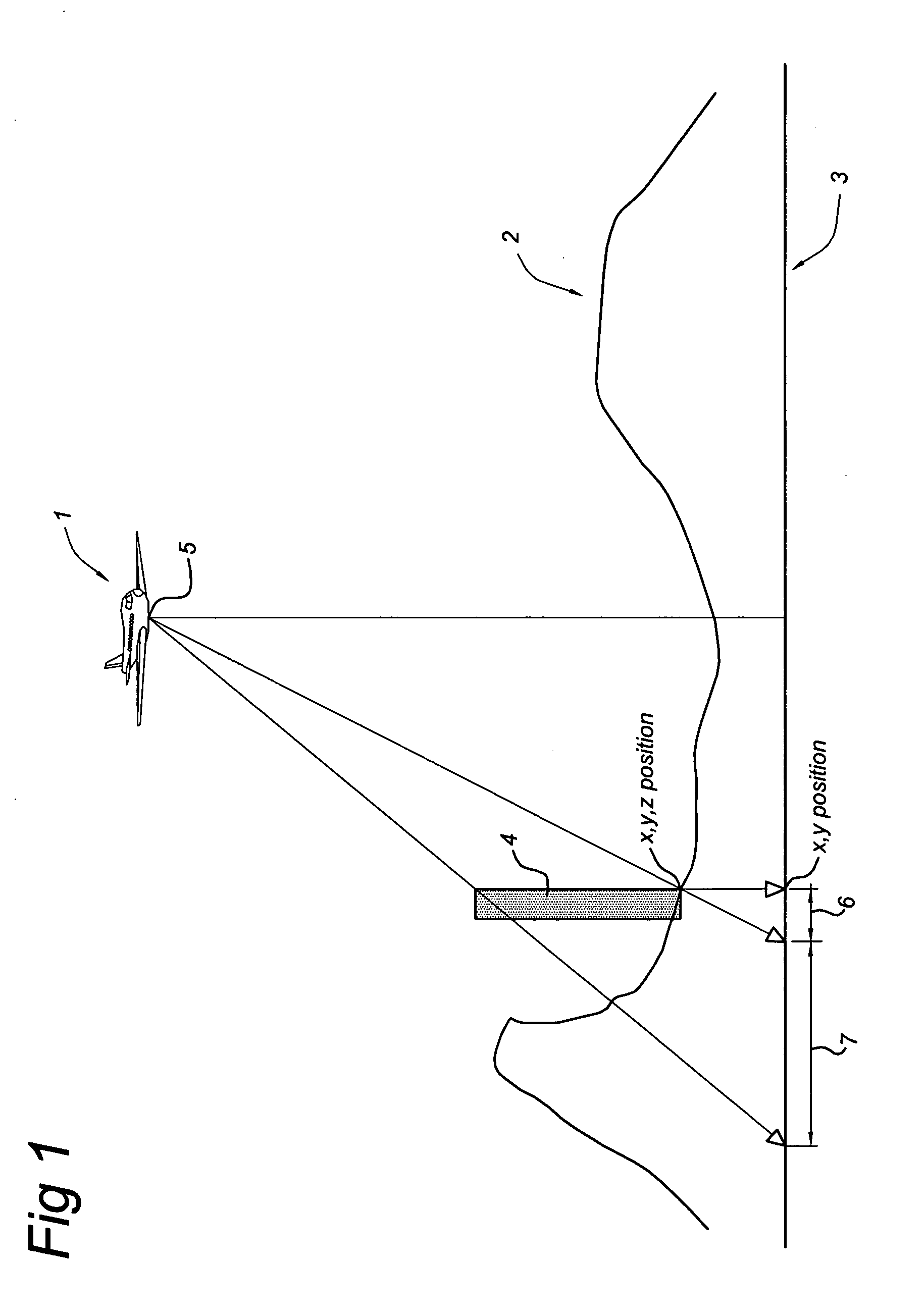
Mobile mapping vehicles capture mobile mapping data captured by means of digital cameras, range sensors, such as
laser /
radar sensors, and position determination means including GPS and IMU mounted to a
vehicle driving across the road based earth surface, the mobile mapping data comprising simultaneously captured image data,
laser /
radar data and associated position data in a
geographic coordinate system. Position determining means enables us to determine the position with a horizontal
absolute accuracy of 50 cm and a vertical accuracy of 1.5 m. By means of the
laser / radar sensor in combination with the determined associated position data, it is possible to create a surface model with a relative horizontal accuracy of 50 cm for 100 m and a relative vertical accuracy of 35 cm for 100 m. With better hardware, i.e. faster range sensor providing a denser laser cloud an accuracy of 1 cm is achievable.
Another
advantage of the 3D surface models according to the invention is, that the 3D model defines both the surface and the edges. The edges are useful to improve the quality of existing DTM's and DSM's. Use of the edges allows for the placement of
cut lines or break lines in the surface model at positions not restricted to the typical
grid pattern of the DEM. In surface models it is not clear how four neighboring survey points should be triangulated, to provide the best approximation of reality. There are two possible results to triangulate the four points, each possibility defining a different surface. Delaunay triangulations will select the result in which the minimum angle of all the angles of the triangles in the
triangulation is maximized. However, this result would not necessarily be the best result to represent the surface in reality. The 3D models of the linear stationary earth surface features according to the invention, i.e. the edges could be used as break lines to control the
triangulation, i.e. to select the result of triangulation of four survey points that approximated best reality. The 3D models could also be used as additional survey points in existing DTM's or DSM's to improve the quality and reliability when using such a surface model in a GIS application or when using the surface model for rectification of
aerial imagery.
As the positional information of the 3D-model in a coordinate reference
system is accurately known, the corresponding part of the image could be rectified accurately. The present invention enables us to generate a huge amount of 3D-models that could be used as GCO's in an easy way and short time period. An
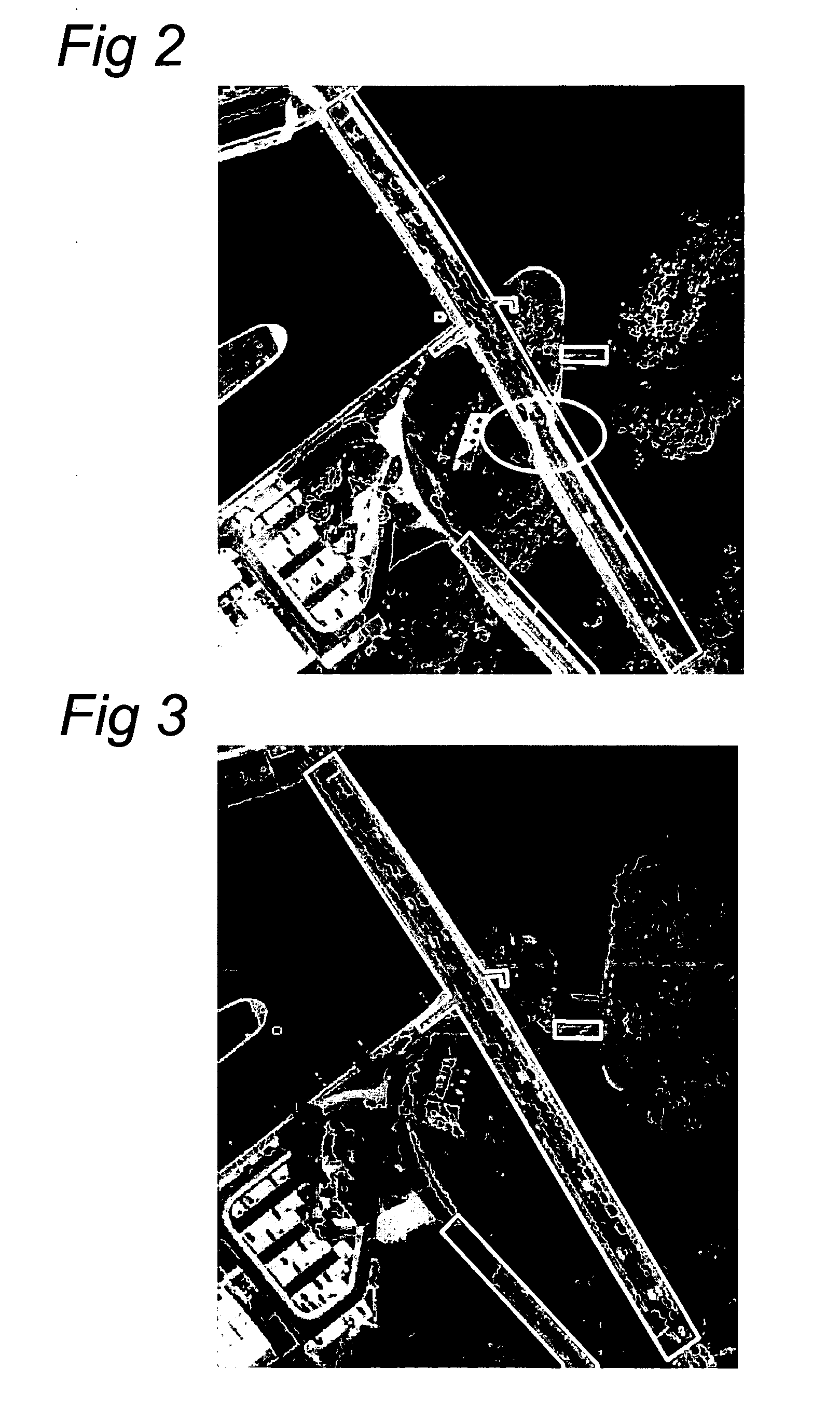
advantage of 3D-models over a database with GCP's is that a 3D-model models a part of earth surface, whereas a GCP refers to only one XYZ-coordinate. When using a database with GCP's, the elevation information of locations between GCP's has to be estimated, which could result in mapping inaccuracies. The method helps us to capture 3D-models of the earth surface. These point objects could only be collected manually by humans using standard survey methods for measuring and modeling the earths surface thereby correcting errors as shown in FIG. 2.
In a further embodiment the 3D-models, which correspond to road segments are linked to obtain a continuous
linear control network; and storing the continuous linear geographic network in the geodetic reference database product. The continuous
linear control network, provides us a continuous and seamless 3D-model of the earth surface which allows us to rectify accurately the image areas corresponding to the road segments. As the road network extends along most parts of the world, by means of this invention, it is possible to generate an accurate road elevation model that could be used to rectify more accurately aerial and
satellite imagery of almost any part of the world. In particular, by means of the continuous
linear control network, it is possible to significantly improve the orthorectification of the roads in the imagery. The continuous linear
control network provides a very accurate DEM or DSM of the surface of the roads and road structures with a resolution which is up to 5 times better than commercially available DSMs or DEMs.
linking the orthorectified images and the elevation information to obtain 3D-orthorectified images; andstoring the 3D-orthorectified images and linking the images to respective 3D-models in the geodetic database product. These features enables us to enhance the 3D-models with visible characteristics of the earth surface of the 3D-model. The characteristics provide additional accurate ground control information related to specific points in the area of a 3D-model. The visible characteristics are also stationary earth surface features. Examples of stationary earth surface feature or a road segment are: road markings such as “Warning of ‘Give Way’ just ahead,”, Stop lines, guidance arrows,
pedestrian crossings, tapered
road edge lines at highway exits, hatched markings, chevron markings, etc. These road markings can be used as additional ground control information which can be used to detect the corresponding road markings in images to be rectified. For example a long straight road segment represented by a 3D-model provides without 3D orthorectified images position information about the beginning, ending and trajectory of the road segment. As the road is straight, the 3D-model does not provide sufficient ground control information along the road segment to verify a position of pixels along the road segment in the image to be rectified. The 3D orthorectified images, visualizing the
road surface and / or road markings, enables the rectification process to match photo-identifiable objects from both sources and to use the position information associated with the 3D orthorectified images to map the corresponding area of the image on the orthorectified imagery. Further more, the 3D orthorectified images enable us to have a network of well distributed ground control points, by means of images of the road markings, to positionally improve the accuracy of navigation and mapping applications. In this embodiment, a 3D-model could include one image representing the colors of the whole orthorectified surface area of the 3D model, a mosaic of orthorectified images, or a set of smaller orthorectified images representing photo-identifiable objects along the model.

