Integrated routing/mapping information

Inactive Publication Date: 2001-11-20
GARMIN
View PDF9 Cites 2137 Cited by
  • Summary
  • Abstract
  • Description
  • Claims
  • Application Information

AI Technical Summary

Benefits of technology

It is an object of the present invention to provide a new integrated routing/mapping information system (IRMIS) capable of enabling the mating and cooperation between desktop and handheld devices, including the automatic updating of related databases whenever the desktop PC and handheld PDA link together. The PDA or handheld personal organizer may be optionally linked to a GPS receiver. It is also an object of the present invention to provide the means to take advantage of the strengths of the desktop or home-base application which provides wider geographical coverage and a fully implemented map/route/point-of-interest (poi) cartographic system, which desktop enables user selectivity or customization of map and route information--optionally tapping into online information. It is another object of the present invention to create data-cutting alternatives such that certain user selections of geographic area, start, finish, POIs, levels of detail or map magnitudes may be effectively downloaded to the PDA/GPS that produce compact map and/or route information "packages" comprising black-white bitmaps, text directions lists, point information organized in differential magnitude configurations which e.g. provide more detail and particular kinds of information around waypoint

Problems solved by technology

While the Rand McNally product incorporates a database of many points of interest, the multimedia travelog information appears limited to preplanned scenic tours.
However the multimedia information available from the database appears limited to "suggested routes of travel" again limiting user choice.
In each case it appears that travel information from multimedia sources is preassembled by editors so that the user or trip planner is limited to "canned" or prepared multimedia travelogs of prescribed, suggested, or preplanned tours.
Or the user is limited to information fragments about this or that particular object of interest or this or that particular place.
There is no opportunity or user capability and selectivity in constructing a user-customized travelog of assembled multimedia information for previewing a particular user determined route of travel.
A disadv

Method used


Image

  • Integrated routing/mapping information
  • Integrated routing/mapping information
  • Integrated routing/mapping information

Examples


Embodiment Construction

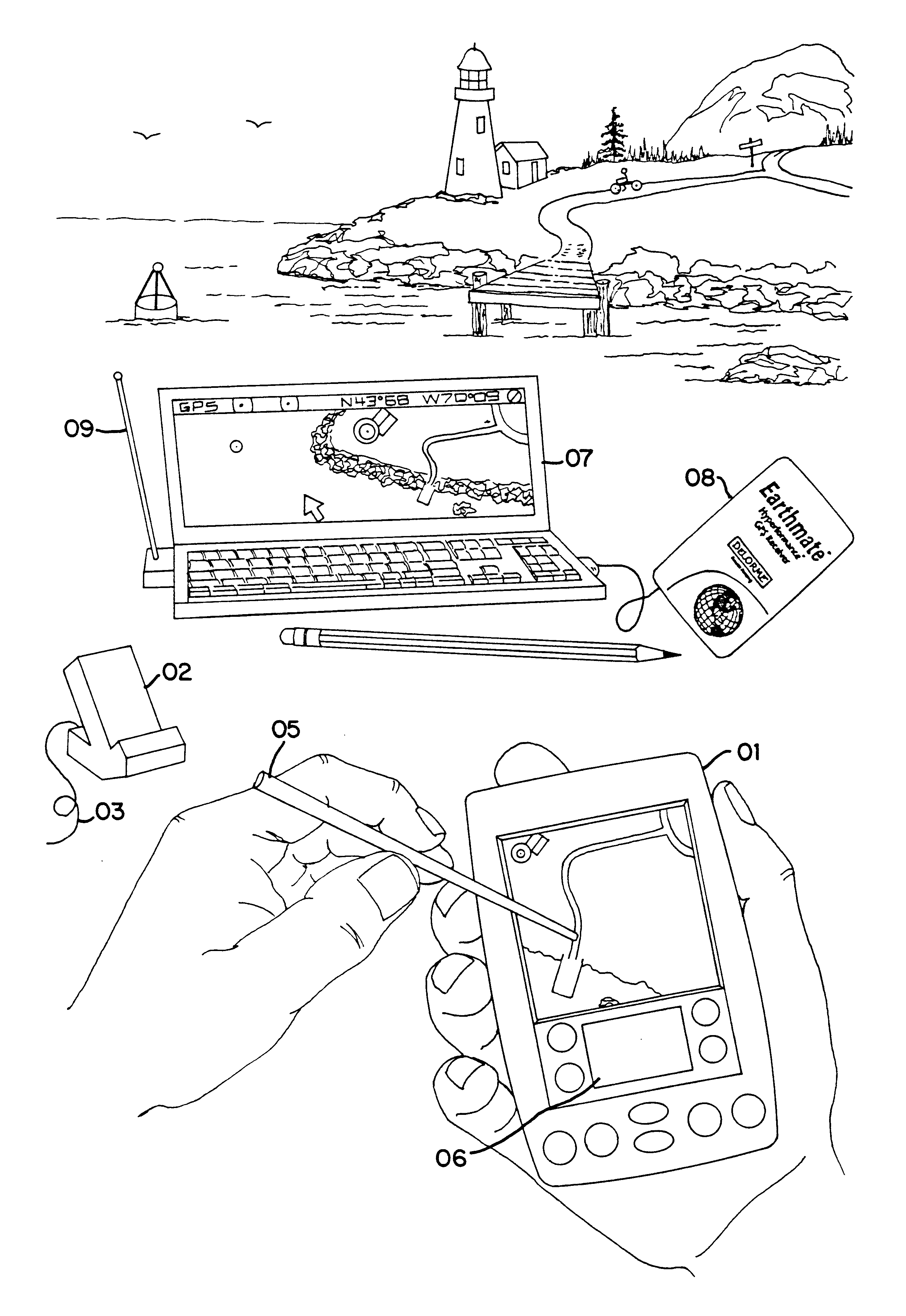
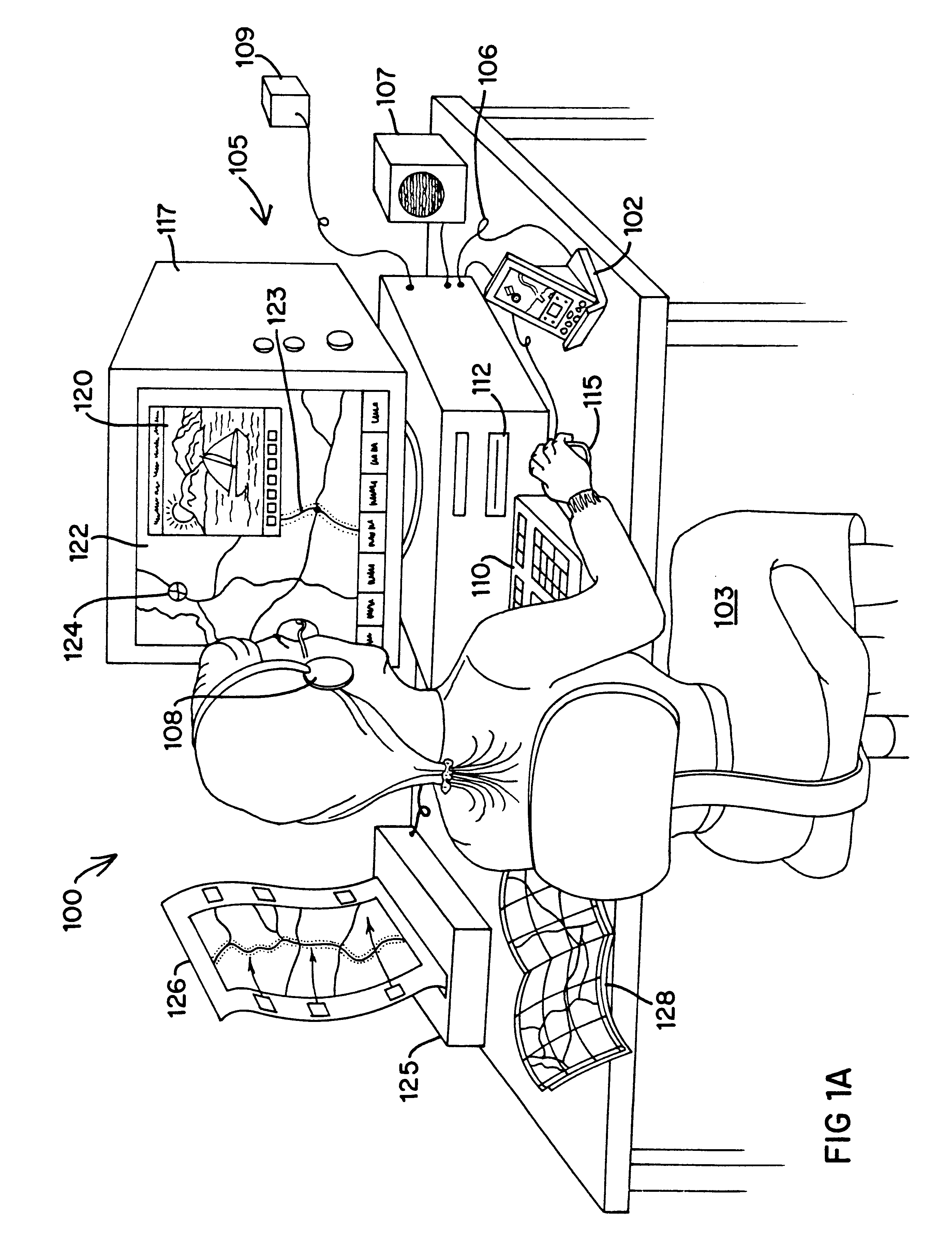
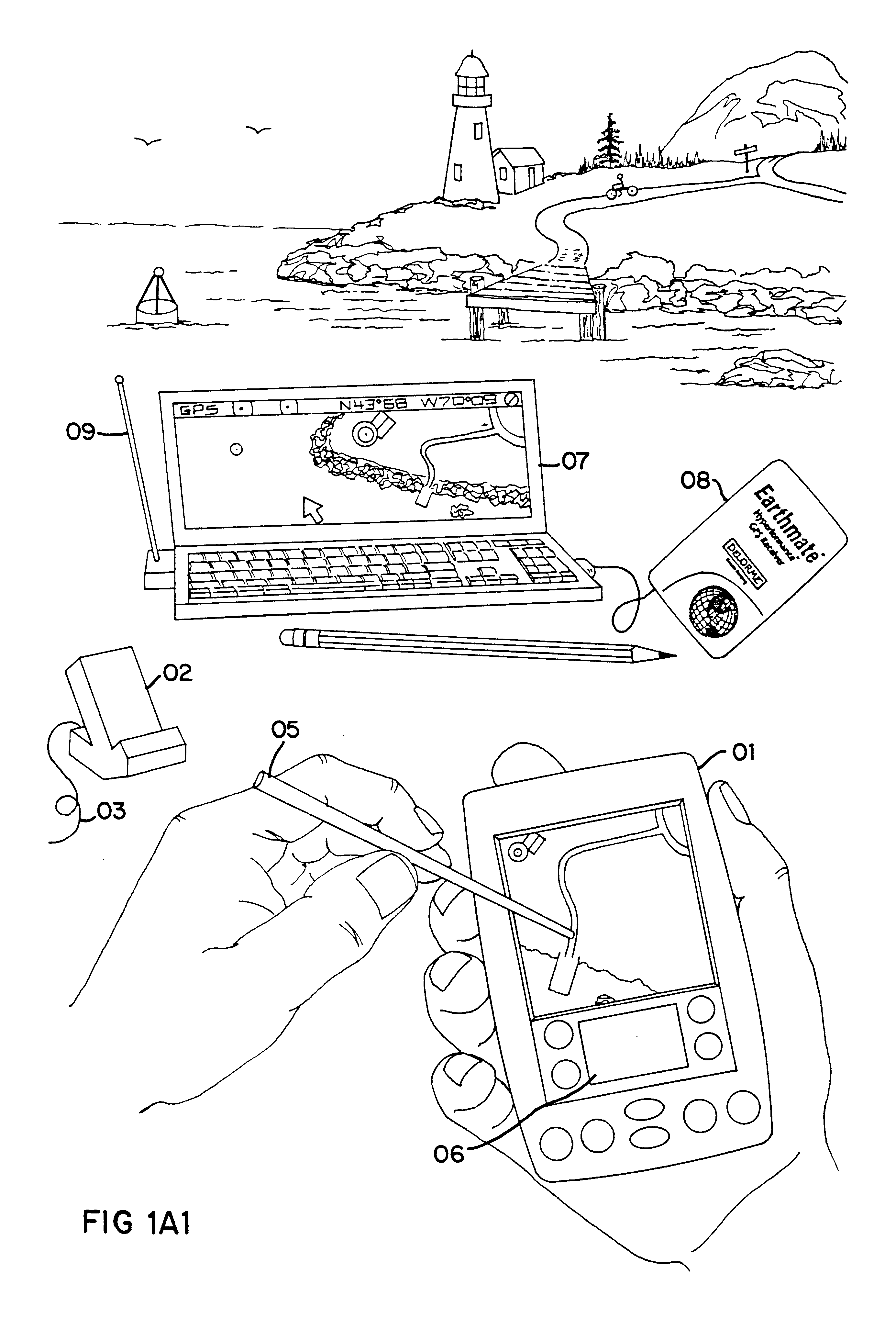
An IRMIS 100 according to the present invention is illustrated by way of example in FIG. 1A. A user 103 operates the software system 100, provided on CD-ROM, utilizing a desktop personal computer equipped for multimedia. In the preferred embodiment, illustrated in FIG. 1A, the desktop computer system 105 includes a 286, 386, 486, or Pentium (TM) Intel (TM) processor or equivalent, with typical memory devices, associated circuitry and peripheral devices including a monitor or cathode ray tube (CRT) 117, a speaker or audio system 107, a printer 125, a CD-ROM player 112, a mouse 115 or similar pointing device, and keyboard 110. Alternatively, the software for the desktop system 105 can be provided on diskette, run from a hard drive or central server (e.g., a local area network internally linked to a mainframe or externally linked to the Internet as shown at 109).

Included for use with IRMIS 100, the desktop computer 105 is integrated with a handheld or palmtop personal organizer PC, als...


PUM


Abstract

An Integrated Routing/Mapping Information System (IRMIS) links desktop personal computer cartographic applications to one or more handheld organizer, personal digital assistant (PDA) or "palmtop" devices. Such devices may be optionally equipped with, or connected to, portable Global Positioning System (GPS) or equivalent position sensing device. Desktop application facilitates user selection of areas, starts, stops, destinations, maps and/or point and/or route information. It optionally includes supplemental online information, preferably for transfer to the PDA or equivalent device. Users' options include route information, area, and route maps. Maps and related route information are configured with differential detail and levels of magnitude. Used in the field, in conjunction with GPS receiver, the PDA device is configured to display directions, text and map formats, the user's current position, heading, speed, elevation, and so forth. Audible signals identifying the next turn along the user's planned route are also provided. The user can pan across maps and zoom between two or more map scales, levels of detail, or magnitudes. The IRMIS also provides for "automatic zooming," e.g., to show greater detail or closer detail as the user approaches a destination, or to larger scale and lower resolution to show the user's overall planned route between points of interest. The IRMIS also enables the user to mark or record specific locations and/or log actual travel routes, using GPS position information. These annotated location marks and/or "breadcrumb" or GPS log data can be saved, uploaded, displayed, or otherwise processed on the user's desktop geographic information or cartographic system. The IRMIS application and data may be distributed online and/or in tangible media in limited and advanced manipulation formats.

Description

This invention relates to a new Integrated Routing / Mapping Information System (IRMIS) for travel planning, travel guidance, and recording travel locations and paths during business or recreational use, particularly in regard to the linkage of small, memory-limited computing systems with personal and / or mainframe computers. The invention may include the capability to provide an interactive computer travel-planning guide for determining a route between a user selected travel origin and travel destination following user selected intermediate waypoints along the way. System software determines the preferred travel route within user selected constraints. The user can also select among a plurality of types of geographically locatable points of interest (POIs) within a user-defined region of interest along the travel route. A database enables the incorporation of travel information such as graphics, photos, videos, animations, audio and text information about the user selectable POIs along...

Claims


Application Information

Patent Timeline
IPC IPC(8): G01C21/36G01C21/34G06Q10/00G08G1/0969G09B29/10G01S19/35G06Q10/02G06Q10/04
CPCG01C21/26G01C21/3476G01C21/36G01C21/3679G06Q10/02G08G1/0969G09B29/106G06Q10/047
Inventor DELORME, DAVID M.GRAY, KEITH A.AUTRY, GORDONMOULTON, KEITH A.
Owner GARMIN
Why Eureka
Try Eureka