Extended kalman filter for autonomous satellite navigation system

a satellite navigation and filter technology, applied in the field of global positioning system based navigation techniques, can solve the problems of inability of most spacecraft operators to find other tracking methods, high cost of operating such systems, and inability to accept most spacecraft navigation applications, etc., to achieve robust signal acquisition, command and telemetry capability, navigation, and orbit determination algorithms.

Inactive Publication Date: 2005-02-22
THE JOHN HOPKINS UNIV SCHOOL OF MEDICINE
View PDF5 Cites 57 Cited by
  • Summary
  • Abstract
  • Description
  • Claims
  • Application Information

AI Technical Summary

Benefits of technology

FIG. 1 illustrates the 660 kg TIMED spacecraft which is three-axis stabilized and NADIR pointing. The majority of the bus electronics are contained in an integrated electronics module (IEM). The IEM is a highly integrated system with major spacecraft bus subsystems implemented on cards in a card cage to eliminate the more common self-contained modules or “black boxes”. The subsystems that populate the IEM are on cards which have common mechanical interfaces based on the Stretch SEM-E form-factor to simplify the design process. Two IBM processors are employed, configured as single-string redundant systems with a 1553 bus connecting the two.
The GNS includes redundant Standard Positioning Service (SPS) receiver systems with access to the GPS civilian ranging code called the coarse acquisition (CA) code that modulates the L1 (1575.42 MHz) signal. The GNS is a state-of-the-art spaceborne system optimized for autonomous on-orbit operations. The GNS is radiation tolerant, has extensive command and telemetry capability, provides access to raw and intermediate data products, supports on-orbit software reprogramming, is designed to accommodate the large doppler signal, dynamic range resulting from orbital velocities, and implements robust signal acquisition, navigation, and orbit determination algorithms.

Problems solved by technology

The “TRANSIT” system used a network of low earth orbit satellites and therefore it was unacceptable for most spacecraft navigation applications.
However, the high cost of operating such systems has forced spacecraft operators to find other tracking methods.
In addition, ground supported satellites are subject to ongoing maintenance costs and are prone to serious malfunction if ground support stations are damaged or if control signal transmissions are interfered with.

Method used


Image

  • Extended kalman filter for autonomous satellite navigation system
  • Extended kalman filter for autonomous satellite navigation system
  • Extended kalman filter for autonomous satellite navigation system

Examples


Embodiment Construction

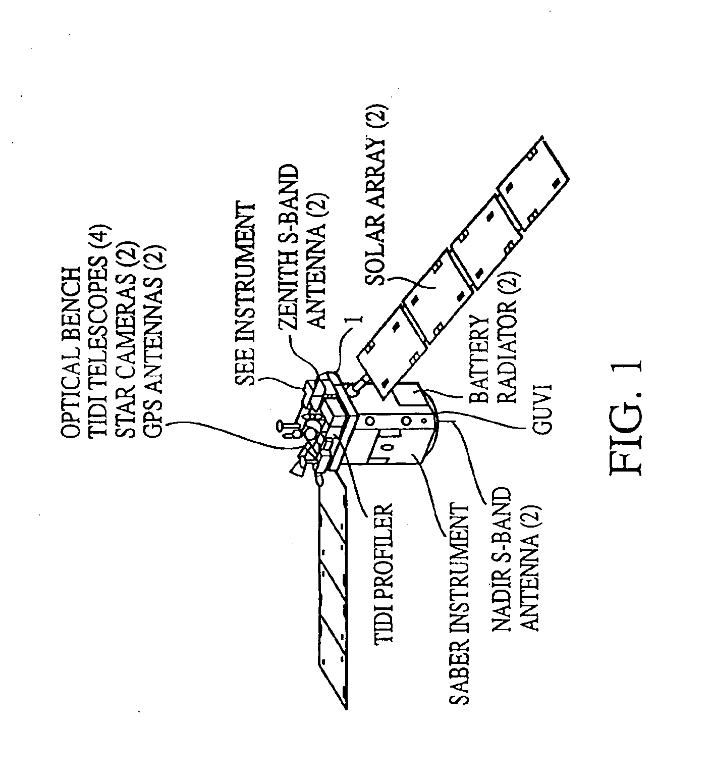
The TIMED spacecraft major components include a system for sounding of the atmosphere using broadband emission radiometry to measure pressure, temperature and infrared cooling. This is the SABER instrumentation package. Located on the underside of SABER, FIG. 1, is a Global Ultraviolet Imager (GUVI) for obtaining temperature profiles and auroral energy inputs. A pair of NADIR S-band antennas are located with the GUVI.

A graphite epoxy optical bench is positioned on top of the SABER instrumentation package. The bench serves as a mounting base for the TIMED Doppler Interferometer (TIDI) profiler and four TIDI telescopes that constitute the TIMED Doppler Interferometer system which obtains wind and temperature profiles. A pair of star cameras, positioned on the bench, provide inputs to attitude star trackers which supply the attitude knowledge requirements of the TIDI. Also positioned on the optical bench is the Solar Extreme-UV Experiment (SEE) which measures solar x-ray, UV and FUV ir...


PUM


Abstract

An autonomous navigation system for an orbital platform incorporating a global positioning system based navigation device optimized for low-Earth orbit and medium-Earth orbit applications including a 12 channel, GPS tracking application-specific integrated circuit (15) operating in concert with a computer system (90) implementing an extended Kalman filter and orbit propagator which autonomously generates estimates of position, velocity and time to enable planning, prediction and execution of event-based commanding of mission operations.

Description

BACKGROUND OF THE INVENTION1. Field of the InventionThis invention relates to global positioning system based navigation techniques for developing position and velocity data required for autonomous operation of satellites incorporating on-board, event-based command systems.2. Discussion of the Related ArtSpacecraft tracking and navigation began when The Johns Hopkins University Applied Physics Laboratory determined Sputnik's orbital parameters as a function of the doppler shift of an on-board radio beacon. That was in 1957. Soon thereafter, that organization devised and developed the Navy Transit Satellite Navigation System which provided global navigation services for the military and civilian community for over 35 years. The “TRANSIT” system used a network of low earth orbit satellites and therefore it was unacceptable for most spacecraft navigation applications.A limited number of experimental systems developed by the Applied Physics Laboratory (APL), NASA and the U.S. Air Force ...

Claims


Application Information

Patent Timeline
Patent Type & Authority Patents(United States)
IPC IPC(8): G01C21/00G01S1/00G01C21/24B60R16/02B64G1/10G01S5/10G01S19/05G01S19/11G01S19/21G01S19/29G01S19/46
CPCG01C21/00G01S19/54G01S19/37G01S19/14
Inventor DEVEREUX, WILLIAM S.CHACOS, ALBERT A.ASHER, MARK S.DUVEN, DENNIS J.KUSTERER, THOMAS L.MORGAN, RICHARD C.
Owner THE JOHN HOPKINS UNIV SCHOOL OF MEDICINE
Why Eureka
Try Eureka