
Method for performing extraction in high turbidity area of lake or reservoir based on remote sensing image

A remote sensing image and turbidity technology, applied in the field of environmental science and monitoring, can solve problems such as affecting the vertical distribution of water temperature and dissolved oxygen, reducing the vertical mixing rate of water temperature, affecting light transmission, etc. Easy-to-use effects

Pending Publication Date: 2019-01-29
NANJING INST OF GEOGRAPHY & LIMNOLOGY
View PDF2 Cites 4 Cited by
  • Summary
  • Abstract
  • Description
  • Claims
  • Application Information

AI Technical Summary

Problems solved by technology

[0005] 3) A large amount of heavy metals, fertilizers and pesticides are carried in the sediments in the highly turbid areas of lakes and reservoirs, which seriously affects the biogeochemical cycle of the water body, thereby affecting the growth of aquatic organisms and human health
[0006] 4) The high concentration of suspended matter in the high turbidity area of ​​the lake and reservoir seriously affects the transmission of light in the water body, which in turn affects the vertical distribution of water temperature and dissolved oxygen, the vertical mixing rate of water temperature decreases, and the cooling time of surface water in winter becomes longer. Changing the structure of thermocline and oxygen layer in nearshore water body, finally affecting the vertical migration of aquatic plants and aquatic animals
However, so far, there are no or few studies on automatic extraction of high turbidity areas in lakes and reservoirs using remote sensing methods

Method used


Image

  • Method for performing extraction in high turbidity area of lake or reservoir based on remote sensing image
  • Method for performing extraction in high turbidity area of lake or reservoir based on remote sensing image
  • Method for performing extraction in high turbidity area of lake or reservoir based on remote sensing image

Examples


Embodiment 1

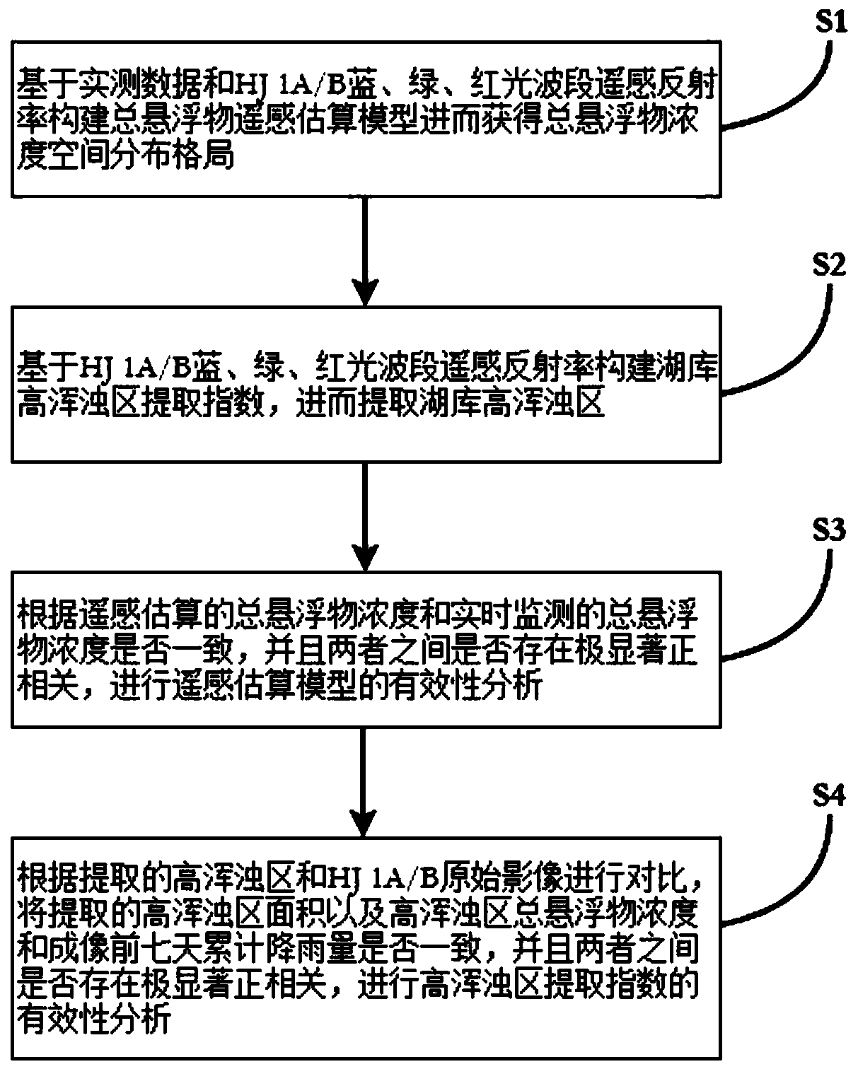
[0041] Such as figure 1 As shown, the present invention discloses a method for extracting high turbidity areas of lakes and reservoirs based on remote sensing images, which includes:

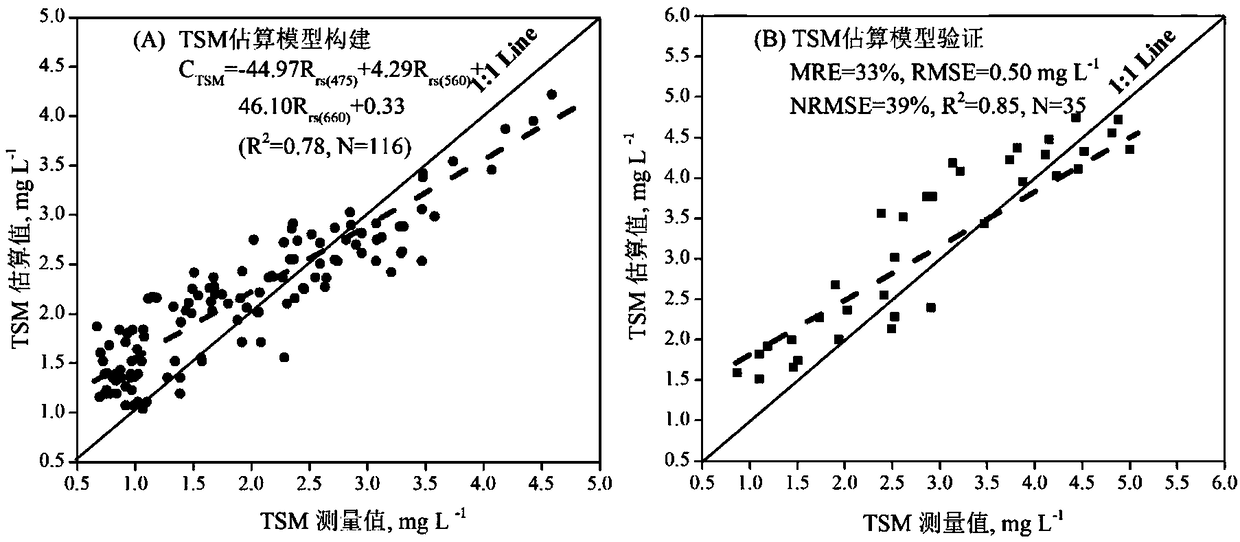
[0042] S1. Based on the measured data and the remote sensing reflectance of HJ 1A / B blue, green, and red light bands, the remote sensing estimation model of total suspended matter is constructed to obtain the spatial distribution pattern of total suspended matter concentration;

[0043] The construction method of the "Total Suspended Matter Remote Sensing Estimation Model" is as follows:

[0044] Through various forms (single band, band ratio, and multi-band, etc.), the combined operation of the 4-band remote sensing reflectance of the CCD sensor of HJ 1A / B is used as the estimation factor of the total suspended particulate matter concentration, and these factors are analyzed Correlation with total suspended particulate matter concentration. Select the estimating factors that have a good corre...

Embodiment 2

[0060] The present invention will be further described below by taking the deep-water lake Qiandao Lake (the water depth is 38.55±16.01m) as an example. Qiandao Lake is located in the upper reaches of the Qiantang River and is one of the most important sources of drinking water in the Yangtze River Delta. With the development of the economy and the rapid increase in population, the original land in the Qiandao Lake Basin is gradually converted to urban or agricultural land. The water storage capacity is destroyed, and the large surface runoff caused by heavy rainfall will carry a large amount of particulate matter, nutrients, pollutants, and heavy metals into the Xin'anjiang Reservoir, thereby increasing the number and scale of algae outbreaks.

[0061] The required data and information of the inventive method are as follows:

[0062] 1) Meteorological data: Long-term daily rainfall data from Chun'an Meteorological Station in Chun'an County, Hangzhou City, Zhejiang Province fr...


PUM


Abstract

The invention provides a method for performing extraction in a high turbidity area of a lake or a reservoir based on a remote sensing image, comprising steps of: constructing a remote sensing estimation model of the concentration of total suspended solids based on measured data and remote sensing reflectance of blue, green and red wavebands of an environmental satellite (HJ1A / B) to obtain the spatial distribution pattern of the concentration of the total suspended solids; constructing an extraction index of the high turbidity area of the lake or the reservoir based on the remote sensing reflectance of blue, green and red wavebands of the HJ1A / B, and performing extraction in the high turbidity area of the lake or the reservoir; analyzing the validity of the remote sensing estimation model and the extraction index of the high turbidity area. The method for performing extraction in a high turbidity area of a lake or a reservoir based on a remote sensing image is suitable for various inland lakes or reservoirs, simple and convenient to operate and easy to popularize and apply.

Description

technical field [0001] The invention relates to the field of environmental science and monitoring technology, and relates to a method for extracting high turbidity areas of lakes and reservoirs based on remote sensing images, in particular to a method for extracting remote sensing images of high turbidity areas of lakes and reservoirs caused by heavy rainfall. Background technique [0002] The water body in the high turbidity area of ​​the lake reservoir is a mixture of sediments, nutrients, heavy metals, organic pollutants and fresh water. These substances have strong absorption and scattering effects on light and affect the structure and function of the lake ecosystem. The impact of water bodies in high turbidity areas on lake ecosystems is multifaceted, mainly including: [0003] 1) Nutrients from agricultural, industrial and domestic sewage sharply increase the nutrient concentration in high turbidity areas, thereby increasing the incidence of harmful algal blooms. [0...

Claims


Application Information

Patent Timeline
Patent Type & Authority Applications(China)
IPC IPC(8): G01C11/00G06F17/18G06T7/62G06T7/90
CPCG01C11/00G06F17/18G06T7/62G06T7/90G06T2207/10032G06T2207/20032Y02A90/30
Inventor 张毅博张运林施坤
Owner NANJING INST OF GEOGRAPHY & LIMNOLOGY
Learn More