
Airborne motion error compensation model for GNSS-R dual-base SAR imaging

A motion error and model technology, which is applied in the field of GNSS-R bistatic SAR imaging airborne motion error compensation model, can solve problems such as blurred image contours, affecting the imaging position of target points, and phase fluctuations of echo signals, etc., to achieve imaging results Improvement, good engineering application value, and good applicability

Active Publication Date: 2019-01-25
金华航大北斗应用技术有限公司
View PDF6 Cites 4 Cited by
  • Summary
  • Abstract
  • Description
  • Claims
  • Application Information

AI Technical Summary

Problems solved by technology

SAR imaging mainly uses the Doppler frequency shift caused by the movement of the transmitter and receiver relative to the detection area for imaging, but the error caused by the mutual movement of the transceiver system will affect the range and azimuth resolution
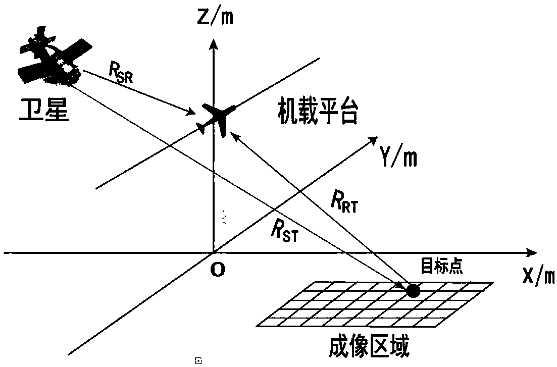
Airborne motion error refers to the deviation of the receiver's own track from the ideal track mainly caused by the speed and acceleration of the aircraft, thereby changing the distance of the receiver to the target point, resulting in a change in the phase of the echo signal, which will not only affect the target point The imaging position will affect the Doppler frequency and Doppler modulation frequency, causing the main lobe to broaden and the amplitude of the side lobe to increase, the image outline to be blurred, and the resolution to be reduced
[0004] At present, most of the research in the field of error compensation is based on traditional radar signals, but there are few studies on GNSS-R signals. This model proposes a motion error analysis and compensation model for GNSS-R bistatic SAR imaging. Signal processing to achieve compensation for motion errors

Method used


Image

  • Airborne motion error compensation model for GNSS-R dual-base SAR imaging
  • Airborne motion error compensation model for GNSS-R dual-base SAR imaging
  • Airborne motion error compensation model for GNSS-R dual-base SAR imaging

Examples


Embodiment 1

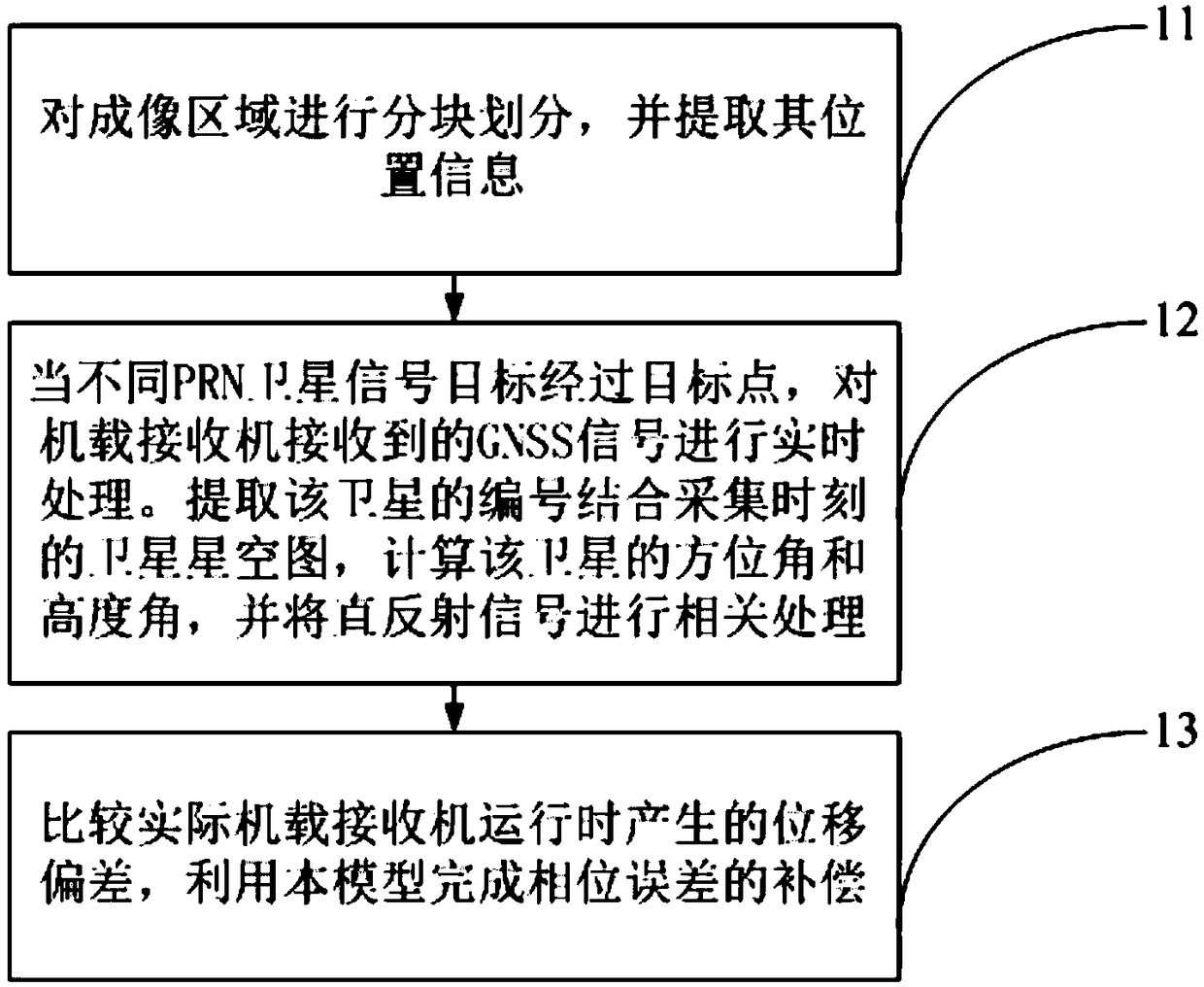
[0053] The invention provides a GNSS-R (global navigation satellite system reflectometry) bistatic SAR imaging system error compensation model. The model analyzes the influence of motion errors on imaging results in the background of airborne receiver experiments, and compensates for different types of velocity errors. Receive the actual echo signal and combine it with the established navigation trajectory, on this basis, use this model to complete the compensation of the airborne motion error.

[0054] The purpose of the present invention is to combine the traditional imaging error compensation model and use the GNSS signal to solve the error effect caused by the deviation of the airborne receiver from the set heading due to air resistance during the synthetic aperture process. Combined with the ideal flight trajectory, the actual echo signal reflected by the target area is extracted. , to analyze the delay of the actual signal. At the same time, the receiver receives the G...


PUM


Abstract

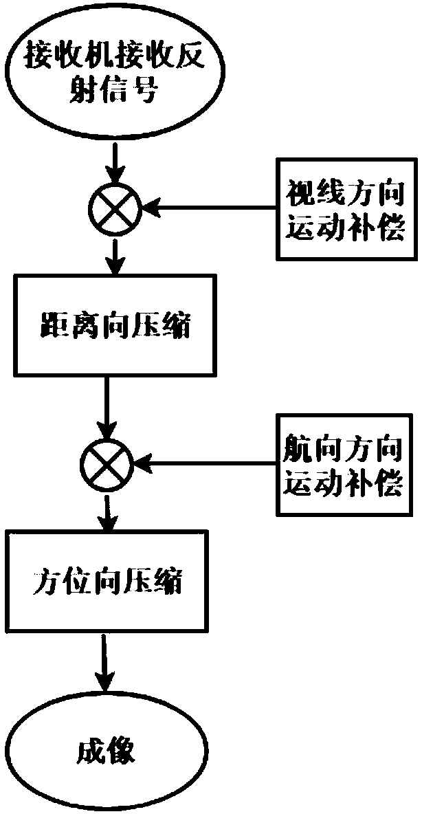
The technical scheme of the invention proposes an airborne receiver motion error compensation model for a GNSS-R dual-base SAR imaging system. The airborne receiver motion error compensation model belongs to the field of navigation, and comprises block division of an imaging region and extraction of positional information thereof. When different PRN satellite signal targets pass a target point, GNSS signals received by an airborne receiver are processed in real time, a serial number of a satellite is extracted and combined with a satellite stellar map at the acquisition moment, azimuth and elevation angles of the satellite are calculated, and a direct reflection signal is subjected to correlation processing. Displacement deviation generated by the airborne receiver during actual operationis compared, and phase error compensation is completed by utilizing the airborne motion error compensation model. Through directly utilizing an actual callback signal time delay value, primary phase compensation is performed in an operation line-of-sight direction of the receiver, a range direction compression result is obtained by carrying out correlation processing on a direct signal, secondaryphase compensation is performed in the heading direction, azimuth Fourier transform is performed, a module value is obtained after decoupling, and an imaging result with high resolution of a target region is obtained.

Description

technical field [0001] The invention belongs to the field of navigation, in particular to a GNSS-R bibase SAR imaging airborne motion error compensation model. Background technique [0002] The signal processed by this model is the GNSS satellite signal, which has the following advantages: 1. The system itself does not emit electromagnetic wave signals, but uses non-cooperative GNSS satellites as the radiation source, which is not easily perceived by the enemy, and has strong survivability and concealment 2. Excellent working performance, can work continuously around the clock and day and night. 3. Since this technology uses GNSS signals, ground base stations can directly use mature GNSS receivers or data collectors, which reduces the overall difficulty and cost of system deployment. [0003] GNSS-R SAR imaging is a passive dual-station SAR imaging system that uses the bistatic SAR system to image the target area using navigation satellite signals as the signal source. SAR...

Claims


Application Information

Patent Timeline
Patent Type & Authority Applications(China)
IPC IPC(8): G01S7/40G01S13/90G01S19/14
CPCG01S7/40G01S13/90G01S19/14G01S13/9058G01S13/9019
Inventor 朱云龙郝令政吴世玉
Owner 金华航大北斗应用技术有限公司
Learn More