
Full-waveform satellite laser ranging system and method

A satellite laser ranging, full-waveform technology, applied in radio wave measurement systems, satellite radio beacon positioning systems, measurement devices, etc., can solve problems affecting system detection efficiency, detection signal-to-noise ratio changes, noise sensitivity, etc. Improve the system detection rate, reduce R&D costs, and increase the number of echo points

Active Publication Date: 2020-10-09
中国科学院国家天文台长春人造卫星观测站
View PDF11 Cites 5 Cited by
  • Summary
  • Abstract
  • Description
  • Claims
  • Application Information

AI Technical Summary

Problems solved by technology

However, under different observation conditions, the detection signal-to-noise ratio will change significantly with the number of APD array elements
Due to the limitations of the APD array manufacturing process, there is a certain gap between each unit to identify the number of echo photons. The existence of the duty cycle will cause the loss of detection echo energy and affect the detection efficiency of the system.
At the same time, the APD array has extremely high sensitivity, which makes the system more sensitive to noise, and the crosstalk between channels is more serious, which has a negative impact on the detection accuracy of the SLR system.

Method used


Image

  • Full-waveform satellite laser ranging system and method
  • Full-waveform satellite laser ranging system and method
  • Full-waveform satellite laser ranging system and method

Examples


Embodiment 1

[0102] 1. Satellite Laser Ranging (Satellite Laser ranging, SLR): Satellite laser ranging technology is a method that measures the round-trip flight time of the laser from the ground observation station to the observation target satellite, and then obtains the distance from the observation target to the ground observation station. measurement technology.

[0103] 2. Full waveform echo: time-domain distribution of echo data during a single ranging process. The full waveform echo is the superimposed effect of the laser pulse contact and interaction between the transmitted pulse and all the pyramids participating in the SLR reflection process.

[0104] 3. PMT: Photo Multiplier tube, photomultiplier tube, photodetector with extremely high sensitivity and fast response speed, can be widely used in photon counting, extremely weak light detection, chemiluminescence, bioluminescence and other research

[0105] 4.APD: Avalanche Photodiode, avalanche photodiode, a kind of single photon...

Embodiment 2

[0113] According to the contents of the present invention, the kilohertz SLR system of Changchun station is transformed into a full waveform SLR system. Among them, the transmitting telescope is a telescope with a diameter of 21cm, and the receiving telescope is a telescope of 60cm; the single pulse energy of the laser is about 1mJ; the transmitting frequency is 1KHz; the laser wavelength is 532nm; the efficiency of the laser transmitting system is 0.6; the laser energy pulse width is 50ps; Pointing deviation, the value is 5", and the system optical path system is a transceiver separation system. According to the content of the present invention, the main wave detector will use high-precision PIN tubes, the echo detector will use ultra-fast response PMT, and the high-precision time analyzer will use GT668, through the development of FPGA to realize the cumulative sampling of the sampling gate controller at equal distances and small intervals.

[0114] Let the observation targe...

Embodiment 3

[0128] Taking the SLR system of Yunnan Astronomical Observatory as an example, the system is upgraded to a full waveform SLR system. The SLR system of Yunnan Astronomical Observatory is a common optical path system for transmitting and receiving, the telescope is 120cm, the pointing accuracy of the telescope is 1", the laser wavelength is 532nm, the single pulse energy is 150mJ, the pulse width is 200ps, and the repetition frequency is 10Hz.

[0129] According to the content of the present invention, the main wave detector will use high-precision PIN tubes, the echo detector will use ultra-fast response PMT, and the high-precision time analyzer will use GT668, and the sampling gate controller will be implemented by developing FPGA to achieve cumulative sampling at equal distances and small intervals .

[0130] Let the observation target be the Ajisai satellite. The Ajisai satellite has 318 reflective flat mirrors and 120 corner reflectors. The specific objects are as follows:...


PUM


Abstract

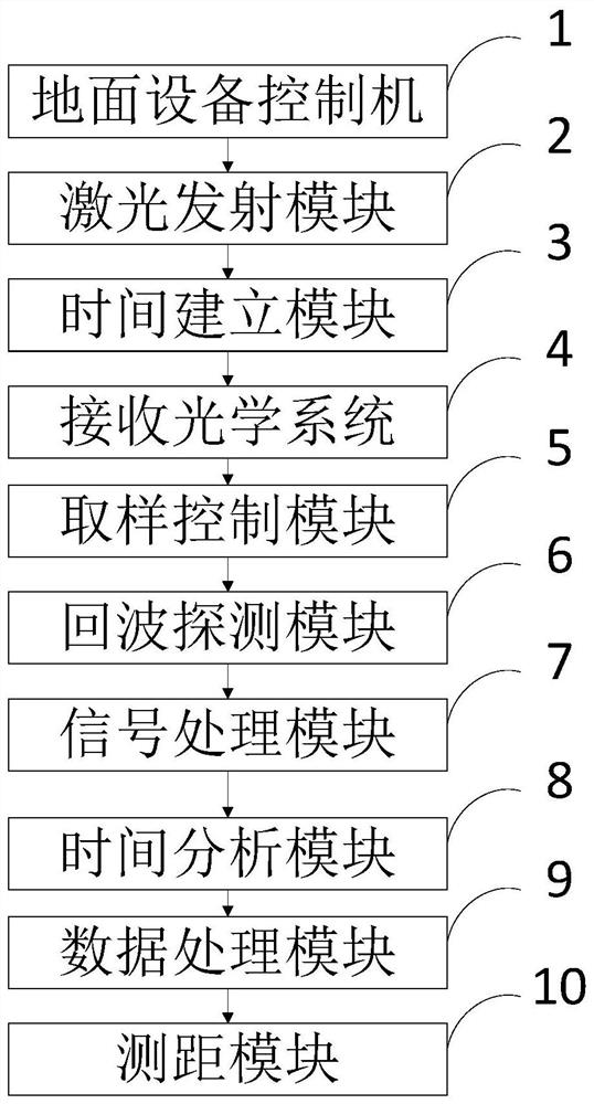
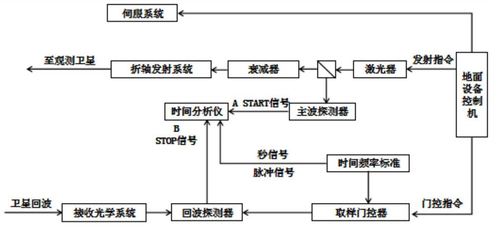
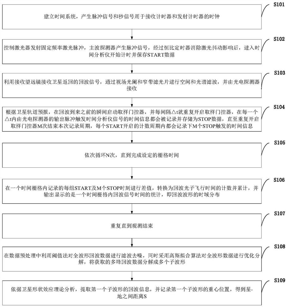
The invention belongs to the technical field of laser ranging, and discloses a full-waveform satellite laser ranging system and method. The system comprises: a ground equipment controller which is used for transmitting an instruction; a laser emission module, which is used for emitting laser pulse; a receiving optical system, which is used for receiving echo signals returned by a satellite; a sampling control module, which is used for starting a sampling door controller; an echo detection module, which is used for conducting sampling for multiple times; a signal processing module, which is used for acquiring SLR full-waveform echo data in a time grid arc section; an time analysis module, which is used for performing converting to obtain echo photon flight time for counting and accumulating; a data processing module, which is used for decomposing the acquired multi-peak echo data into a plurality of sub-waveforms; and a ranging module, which is used for acquiring the distance S betweenthe satellite and the ground. The system has direct application value for optimization design of a high-precision SLR system and design of a target recognition algorithm, and further has very important scientific value for perfection of a laser ranging theoretical system.

Description

technical field [0001] The invention belongs to the technical field of laser distance measurement, and in particular relates to a full waveform satellite laser distance measurement system and method. Background technique [0002] Establishing, maintaining and updating a high-precision Earth reference frame is the primary scientific research task of the Global Geodetic Observation System (GGOS). The continuous improvement of the Earth's reference frame not only provides basic data for national defense security, deep space exploration, urban construction, disaster relief and mitigation, but also provides a unified spatial benchmark for scientific research on global changes. Although the current international earth reference frame has reached centimeter-level accuracy, it still cannot meet the urgent needs of global and large-scale geodynamic research for its accuracy, stability, and globalization. Therefore, breaking through and mastering modern space geodetic technology has ...

Claims


Application Information

Patent Timeline
IPC IPC(8): G01S17/08G01S7/48G01S19/42G01S19/08
CPCG01S17/08G01S7/4802G01S19/42G01S19/08
Inventor 安宁高健温冠宇宋清丽董雪梁智鹏刘承志范存波
Owner 中国科学院国家天文台长春人造卫星观测站
Learn More