Water body environment terrain construction method based on scatter data

A construction method and point data technology, which is applied in the field of water environment topography construction, can solve the problems of insufficient measurement data, difficult to obtain topographic data, and difficulty in accurately grasping the flood movement trend and sediment transport law. Interpolation error, reduce measurement workload, improve the effect of smoothness

Active Publication Date: 2021-08-31
SICHUAN UNIV
View PDF17 Cites 1 Cited by
  • Summary
  • Abstract
  • Description
  • Claims
  • Application Information

AI Technical Summary

Problems solved by technology

[0004] Water environmental topography is a key part of understanding reservoirs, rivers, watersheds, and oceans. However, due to the complex and changeable water environmental topography and the limitation of the natural environment, the measured data is insufficient, and it is difficult to reflect the complete underwater topography. Movement trends, sediment transport laws, and water pollutant distribution have brought great difficulties
Although the terrain generation method in areas without data can obtain large-scale terrain data, it is difficult to obtain accurate terrain data due to the limitation of resolution, which has greatly affected the numerical simulation process; while the terrain in areas with data Generation methods, such as based on the shape of the channel section, often divide the channel section into U-shaped, V-shaped and flat-shaped structures only through the channel boundary line and deep-flow line, which is difficult to reflect the real topography and diversity of the channel section

Method used


Image

  • Water body environment terrain construction method based on scatter data
  • Water body environment terrain construction method based on scatter data
  • Water body environment terrain construction method based on scatter data

Examples


Embodiment 1

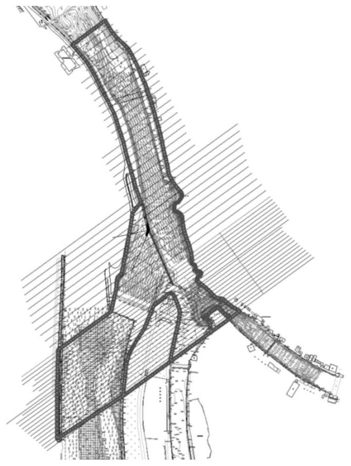
[0046] In this embodiment, taking the section of the Neijiang River in Dujiangyan, Sichuan Province as an example, the water environment terrain construction method based on scattered point data provided by the present invention is described in detail.

[0047] The Neijiang River section of Dujiangyan is located in Dujiangyan City, Sichuan Province. As the Minjiang River and Baisha River are typical mountainous rivers, the flow and water levels vary greatly and the bed-forming ability is strong, resulting in drastic changes in the river bed shape of the target river section. In addition to being affected by the natural environment, the Neijiang River section The impact of the water flow is also affected by the Feishayan, Baopingkou and other facilities, and the law of water flow is complicated. The inflow of the Dujiangyan Neijiang section flows into the Chengdu Plain through Baopingkou, and its riverbed shape has a direct impact on the flood control and water diversion irrigat...

Embodiment 2

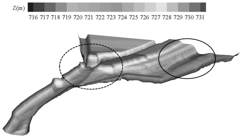
[0069] In the present embodiment, based on the physical model, verify whether the water environment topography of the target area constructed in embodiment 1 is accurate, the specific steps are as follows:

[0070] 1. Building physical models and conducting hydrodynamic experiments

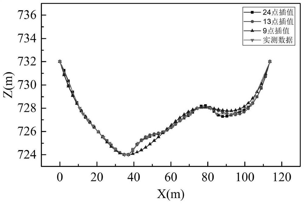
[0071] The physical model experiment was carried out at the test site of the State Key Laboratory of Hydraulics and Mountain River Development and Protection of Sichuan University. The terrain of the model is based on the scattered point data measured in the field, and the normal model scale of 1:50 is used for construction. The water depth measurement adopts the LH-1 automatic water level gauge, the data sampling frequency is 0.5Hz, and the data collection time is 15min. Set 7 measurement cross-sections in the physical model, denoted as 1#~7# measurement cross-sections, such as Figure 8 shown.

[0072] In the above physical model, the inflow of the target river section is 800m 3 / s working c...


PUM


Abstract

The invention provides a water body environment terrain construction method based on scatter data. The water environment terrain construction method comprises the following steps: (1) obtaining terrain scatter data of a target area through field investigation and drawing a CAD graph; (2) extracting transverse distance, longitudinal distance and elevation data of actual measurement points on the cross section of each river channel; (3) carrying out interpolation on each river section by adopting a cubic spline interpolation function; (4) performing linear interpolation on the whole target area through the triangular mesh to obtain a planar topographic map of the target area; (5) converting the planar topographic map of the target area into a riverbed curved surface of the target area; and (6) calculating the thickness of a riverbed movable layer of the target area under the existing hydraulic condition, and vertically stretching the curved surface of the riverbed on the basis of the thickness of the riverbed movable layer so as to complete the construction of the water environment terrain of the target area based on the scatter data. According to the method, the accuracy of the constructed water body environment terrain can be improved, and technical support can be provided for establishing a river flood and sediment transportation and pollutant diffusion model.

Description

technical field [0001] The invention belongs to the field of water body environment topography construction, and relates to a water body environment topography construction method based on scattered point data. Background technique [0002] In recent years, the development and utilization of water resources has become the focus of economic development. In order to better develop water resources, it is necessary to have a comprehensive and clear understanding of the water environment topography. Water environmental topography is an important part of watershed management and development, flood control and drought relief system, and water resource development and utilization. At the same time, water environmental topography is closely related to flood movement trends, sediment transport laws, and water pollutant distribution. [0003] The water body environment is affected by various factors such as river erosion, sediment deposition, and geological structure to form a complex ...

Claims


Application Information

Patent Timeline
Patent Type & Authority Applications(China)
IPC IPC(8): G06T17/05G06T17/10G06F30/13
CPCG06T17/05G06T17/10G06F30/13Y02A90/30
Inventor 王协康程凯杨青远刘昌军孙东亚闫旭峰
Owner SICHUAN UNIV
Why Eureka
Try Eureka