Sky-ground integrated agricultural remote sensing big data system based on smart agriculture

A technology of sky, earth and big data, applied in the field of smart agriculture, can solve problems such as inability to help farmers, lack of crop growth simulation, and inability to realize management

Pending Publication Date: 2022-03-18
安徽易刚信息技术有限公司
View PDF0 Cites 9 Cited by
  • Summary
  • Abstract
  • Description
  • Claims
  • Application Information

AI Technical Summary

Problems solved by technology

[0004] 1. The existing smart agricultural management system generally considers the hierarchical establishment of space resources and ecological agriculture. It only monitors agricultural plants without analyzing the planting soil, that is, it cannot formulate according to different project plots. Special formula ratio of nitrogen, phosphorus and potassium required, ratio of elemental base fertilizer, topdressing and other schemes;
[0005] 2. The existing intelligent agricultural management system lacks the growth simulation of crops, that is, the targeted data information is only the planting information of the current year, and lacks adjustment management for the overall growth trend of the second year, and cannot help farmers optimize the management plan;
[0006] 3. The data collected by the existing smart agriculture is often only the water quality data, insect data and seedling data required for the growth of crops, that is, the range of collected data is incomplete, which makes it impossible to achieve better management

Method used


Image

  • Sky-ground integrated agricultural remote sensing big data system based on smart agriculture
  • Sky-ground integrated agricultural remote sensing big data system based on smart agriculture

Examples


Embodiment 1

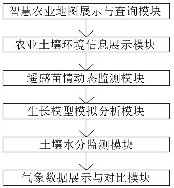
[0034] see Figure 1~2 , an air-ground integrated agricultural remote sensing big data system based on smart agriculture, including

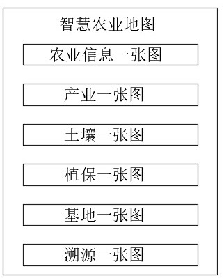
[0035] The smart agricultural map display and query module can display agricultural construction results maps, high-standard farmland construction results, land contract management rights confirmation registration and certification results, as well as village-level township boundaries, the latest satellite remote sensing images and other data; The property data of the vector data can be queried spatially through methods such as , surface, etc., and can also be queried by searching, so as to quickly locate the property and position of the target plot;

[0036] In the embodiment of the present invention, in the smart agricultural map display and query module, the smart agricultural map includes:

[0037] ① A map of agricultural information: it is used to display meteorological data, water quality data, insect data, seedling data, industrial data,...

Embodiment 2

[0044] see Figure 1~2 , an air-ground integrated agricultural remote sensing big data system based on smart agriculture, including

[0045] The agricultural soil environment information display module, according to the soil test data provided by the agricultural department, through spatial interpolation, makes the spatial distribution map of nitrogen, phosphorus, potassium, organic matter, and pH, and displays it in the system. Different types can be switched by buttons , and the soil nutrient attributes at any point can be queried in the form of points, surfaces, etc.;

[0046] The dynamic monitoring module of remote sensing seedling situation, after obtaining high-resolution satellite data through space satellites, establishes the correlation relationship between the satellite vegetation index data and the agronomic data obtained from the ground sampling point data, and uses the correlation relationship to estimate the leaf area index of the plot scale. Biomass and abovegr...


PUM


Abstract

The invention discloses a sky-ground integrated agricultural remote sensing big data system based on smart agriculture. The sky-ground integrated agricultural remote sensing big data system comprises a smart agriculture map display and query module, an agricultural soil environment information display module, a remote sensing seedling condition dynamic monitoring module, a growth model simulation analysis module, a soil moisture monitoring module and a meteorological data display and comparison module. The system has the beneficial effects that dynamic monitoring data of crop growth vigor, flood and drought disasters, diseases and pests and the like are realized, and the optimized fertilization quantity, the base fertilizer and topdressing fertilizer distribution proportion, the fertilization period and the fertilization method of different crops in each fertilization unit are mastered through field trials; basic parameters such as a soil nutrient correction coefficient, a soil fertilizer supply capability, nutrient absorption amounts of different crops and a fertilizer utilization rate are found out; a crop fertilization model is constructed, a basis is provided for fertilization partitions and fertilizer formulas, the basis is presented to governments at all levels and agricultural competent departments in a visual mode, and the functions of real-time monitoring, risk early warning and data analysis of global disease and pest occurrence situations are achieved.

Description

technical field [0001] The invention relates to an agricultural remote sensing big data system, specifically an air-ground integrated agricultural remote sensing big data system based on smart agriculture, which belongs to the technical field of smart agriculture. Background technique [0002] Agriculture is the foundation of the national economy. With the improvement of agricultural industrialization and scale, and Internet of Things technology, cloud computing technology, big data technology, geographic information system, remote sensing and global positioning system technology are more and more widely used in the agricultural field , the traditional agricultural farming mode has gradually exposed some shortcomings, and "smart agriculture" can fully apply the achievements of modern information technology, integrate the application of computer and network technology, Internet of Things technology, audio and video technology, 3S technology, wireless communication technology a...

Claims


Application Information

Patent Timeline
Patent Type & Authority Applications(China)
IPC IPC(8): G06Q50/02G06Q30/00G06T3/40G06Q10/06G06F16/29
CPCG06Q50/02G06Q30/018G06Q10/063G06T3/4007G06F16/29Y02A10/40
Inventor 查海涅张子玉查沛郝娟娟焦迎庆
Owner 安徽易刚信息技术有限公司
Why Eureka
Try Eureka