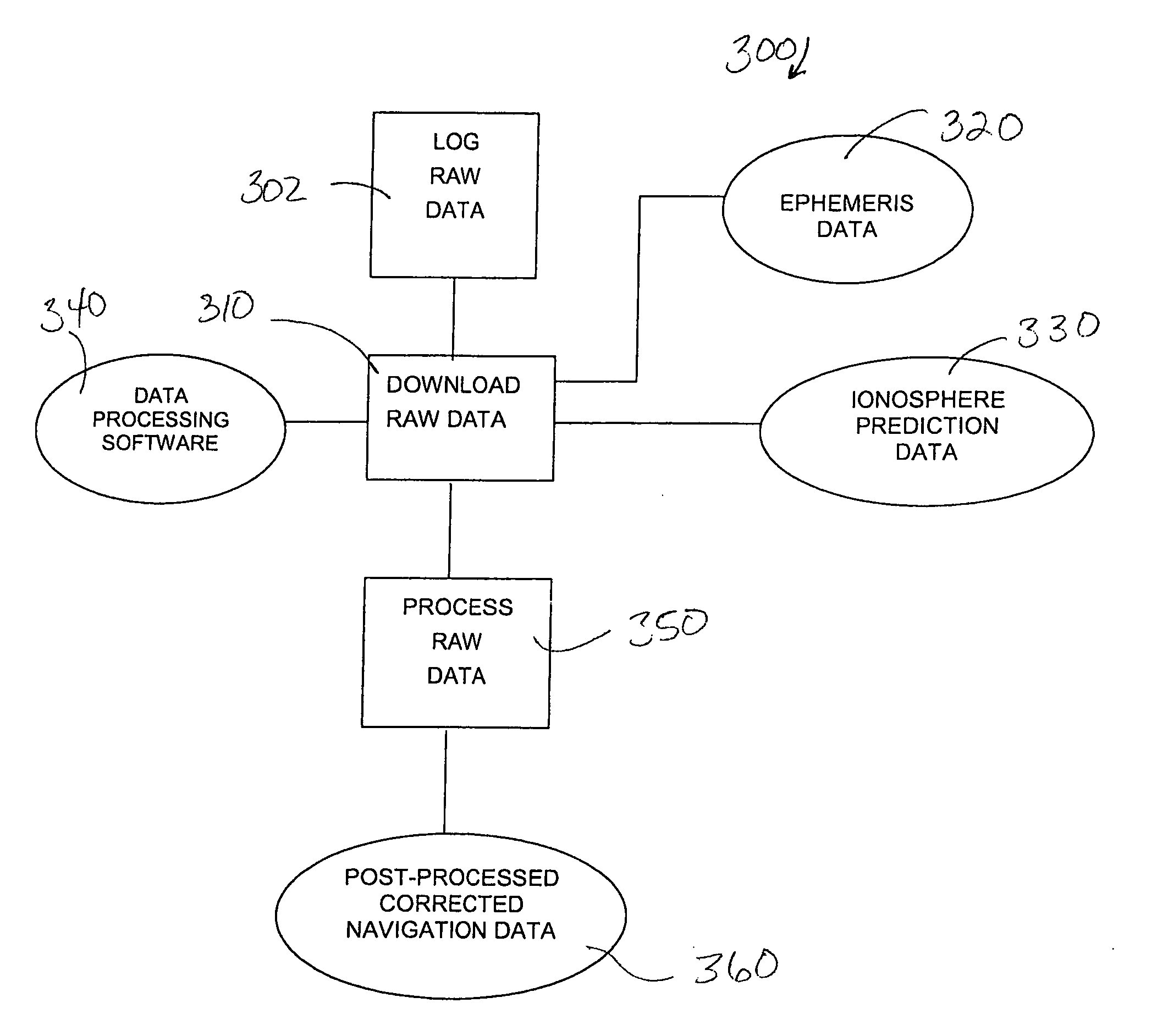
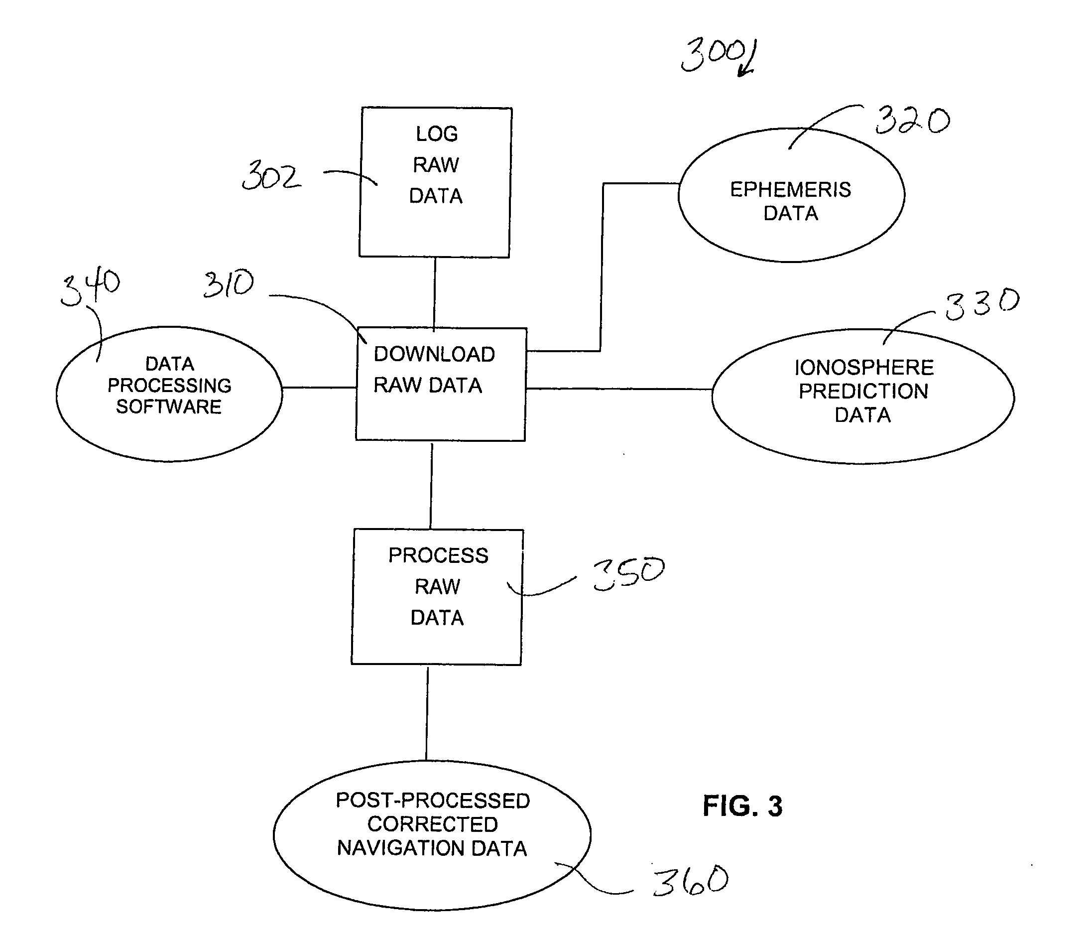
[0011] For the reasons cited above, it is an object of the present invention to provide a small, inexpensive, stand-alone device that logs raw GPS data and does not require the input of an external signal. It is a further object to provide a method of post-
processing the
raw data to obtain navigation data that has sub-meter accuracy. It is a yet further object to provide a method of real-
time processing of logged raw GPS data to obtain data with sub-meter accuracy, in real-time, without requiring a
wireless or other connection to a GPS reference
station during
data processing.
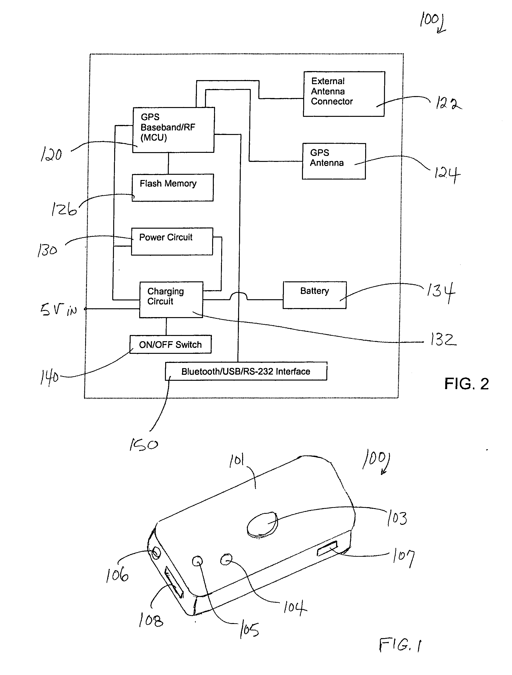
[0013] The GPS receiver / data logger comprises a conventional GPS
baseband /
radio frequency (RF)
chip, an antenna, a memory, an external-device interface, and a power circuit. The power circuit is connected to a charging circuit, an internal battery, and an ON / OFF switch. The components of the GPS receiver / data logger are conventional commercially available components: the GPS
chip is available from SIRF, the memory is an AMD
flash memory, the antenna an internal
ceramic patch antenna, the battery a rechargeable
Lithium-
ion battery, and the external-device interface is a
Bluetooth,
USB, or RS-232 interface. For ease of use and convenience, the external-device interface is a
bluetooth wireless interface, that enables connection of the GPS receiver / data logger with an external computing device, such as a desktop computer or PDA. The GPS receiver / data logger lacks a display and control buttons, other than the ON / OFF switch, which switches the GPS receiver / data logger off completely, rather than putting it into
sleep mode.
[0019] Just as with
logging navigation data, various filters may be also used to control the
logging of raw data, to increase the efficiency and use of memory in the logger. One example of a useful filter for initiating or halting logging is the speed of the vehicle. The GPS receiver / data logger is programmable to
log data only when the vehicle is moving, or only when the vehicle is traveling above or below a certain threshold speed, etc.
[0020] The uses of the GPS receiver / data logger described above are typical for vehicle tracking. The GPS receiver / data logger and the method according to the invention are also quite suitable for collecting data for mapping applications. In such applications, the GPS receiver / data logger is used in a single-click operation to
record raw GPS data from a series of points from a
geographic area. The GPS receiver / data logger is set at a first location and turned on. The GPS receiver / data logger records data and shuts off automatically after a pre-programmed period of time. The accuracy of the data increases with the amount of time the data logger logs at one location and, thus, the GPS receiver / data logger should ideally be allowed to
log data at a single location for several minutes, and, preferably, for 20 minutes. The user then moves the GPS receiver / data logger to a new location, clicks it on and lets it
record data for the pre-programmed period of time. In this manner, the user may
record data from a series of locations that encompass the
geographic area. The raw GPS data is post-processed, in the manner described above, to obtain accurate
terrain data that is then registrable on a map of given coordinates.
[0021] The GPS receiver / data logger according to the invention is a simple device, without display and controls, other than an ON / OFF switch, and, thus, is inexpensive. The cost of acquiring multiple such devices is much less than acquiring a conventional GPS
system that provides corrected navigation data with sub-meter accuracy. It is particularly useful and cost-effective to acquire multiple GPS receiver / data loggers for use in mapping. The user may then set up multiple GPS receiver / data loggers at multiple locations around the perimeter of an area to be mapped, thereby eliminating wait time while simultaneously obtaining multiple recordings that are then used to obtain a precise map of the area. Obtaining multiple recordings from various locations in geographically close proximity has the added
advantage in that the data points thus obtained may be used to further increase the accuracy of the corrected navigation data.

