Laser radar-based mini-sized unmanned plane control method and system

A technology of laser radar and unmanned aerial vehicles, applied in the field of unmanned aerial vehicles, can solve the problems of inapplicability, high hardware consumption, large measurement error, etc., and achieve the effect of not being affected by ambient temperature and sunlight, strong electromagnetic interference ability, and anti-stealth ability strong effect

Inactive Publication Date: 2016-07-13
SHENZHEN LONGING INNOVATION AVIATION TECH CO LTD
View PDF11 Cites 23 Cited by
  • Summary
  • Abstract
  • Description
  • Claims
  • Application Information

AI Technical Summary

Problems solved by technology

[0003] In recent years, with the widespread promotion of drone products, the navigation technology of drones has made great progress. With the progress of electronics and remote communication, long-distance wireless navigation systems have been realized, such as phased array radar and GPS and other technologies, but most of the navigation technologies are only suitable for outdoor open spaces, and cannot be applied to low-altitude complex environments, especially indoor navigation in unknown environments
Although there are similar navigation technologies in indoor or low-altitude complex environments in the industry, such as landmark recognition and navigation technology based on visual information, its applicable environment is limited, it has high requirements for ambient light, and the visual algorithm is complex and hardware consumption Large, real-time and accuracy have high requirements for software and hardware; navigation technology based on sonar sensors, due to large measurement errors, the amount of environmental information obtained is small, and cannot be applied in complex indoor environments. When multiple sonar sensor arrays are used to obtain more environmental information, due to the fan-shaped area emitted by the sonar sensor at a scattering angle, crosstalk may occur when the indoor environment is crowded, resulting in inaccurate distance measurement information; based on optical flow Although the attitude estimation and motion recovery algorithms of the sensor can be better applied to autonomous navigation in unfamiliar environments, the speed of visual information resolution and the reliability of optical flow still need to be improved.
Therefore, autonomous navigation in low-altitude complex environments has always been a bottleneck for the wide-scale application of micro-UAVs
[0004] At present, the existing low-altitude and complex environment navigation technology in the industry has high environmental requirements, low anti-interference ability and reliability, and complex algorithms, huge hardware consumption, real-time performance and accuracy have high requirements for software and hardware.

Method used


Image

  • Laser radar-based mini-sized unmanned plane control method and system
  • Laser radar-based mini-sized unmanned plane control method and system
  • Laser radar-based mini-sized unmanned plane control method and system

Examples


Embodiment Construction

[0034] It should be noted that the embodiments in the present application and the features of the embodiments may be combined with each other in the case of no conflict.

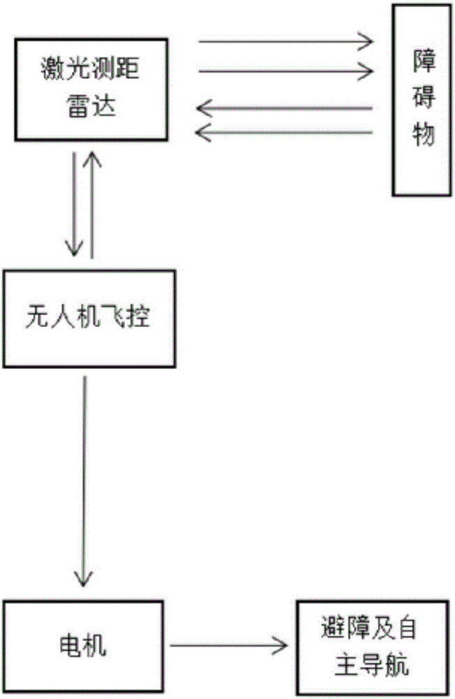
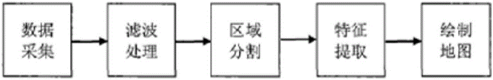
[0035] refer to figure 1 , is a schematic diagram of an unmanned aerial vehicle control system based on laser ranging radar according to an embodiment of the present invention. The UAV obstacle avoidance and autonomous navigation system consists of a laser ranging radar module and a flight control system. The laser ranging radar transmits the collected distance data and visual data to the UAV flight control system in real time. The flight control system passes the internal The central processor analyzes the data information of the ranging radar, and processes it through a variety of algorithms such as pose solving, map construction, and dynamic obstacle avoidance, and fuses it with the aircraft attitude through a special algorithm, and converts it into a motor drive signal to control the flight of the UAV. ...


PUM


Abstract

The invention discloses a laser radar-based mini-sized unmanned plane control method comprising the following steps: real time laser range finding information is collected; according to the laser range finding information, an unmanned plane position and pose solution is sought, synchronous positioning and map building are conducted, and dynamic air route planning is conducted; after electric motor driving signals are generated, the flight of an unmanned plane can be controlled. A laser radar-based mini-sized unmanned plane control system is disclosed and comprises an unmanned plane flight control module, a laser range finding radar module and an electric motor. Low altitude complex environment unmanned plane autonomous navigation key technologies are applied to the field of equipment for civil use, and the reliability of low altitude complex environment navigation is improved while hardware cost is lowered. The laser radar-based mini-sized unmanned plane control method and system are widely applied to the technical field of unmanned planes.

Description

technical field [0001] The invention relates to the technical field of unmanned aerial vehicles, in particular to a laser radar-based control method and system for micro unmanned aerial vehicles. Background technique [0002] IMU: Inertialmeasurementunit, inertial measurement unit. [0003] In recent years, with the widespread promotion of drone products, the navigation technology of drones has made great progress. With the progress of electronics and remote communication, long-distance wireless navigation systems have been realized, such as phased array radar and GPS and other technologies, but most of the navigation technologies are only suitable for outdoor open spaces, and cannot be applied to low-altitude complex environments, especially indoor navigation in unknown environments. Although there are similar navigation technologies in indoor or low-altitude complex environments in the industry, such as landmark recognition and navigation technology based on visual inform...

Claims


Application Information

Patent Timeline
Patent Type & Authority Applications(China)
IPC IPC(8): G05D1/08G05D1/10
CPCG05D1/0808G05D1/101G05D1/102
Inventor 鲍静云王亚范晋红殷兰兰
Owner SHENZHEN LONGING INNOVATION AVIATION TECH CO LTD
Why Eureka
Try Eureka