Unmanned aerial vehicle aerial photography measurement method and system
A measurement method and UAV technology, applied in photogrammetry/video surveying, measurement devices, surveying and navigation, etc., can solve the problems of poor aerial photography effect of UAVs, failure to take into account weather conditions and equipment detection, etc. Significant mobility and flexibility, good feedback ability, reduced input effect
- Summary
- Abstract
- Description
- Claims
- Application Information
AI Technical Summary
Problems solved by technology
Method used
Image
Examples
Embodiment 1
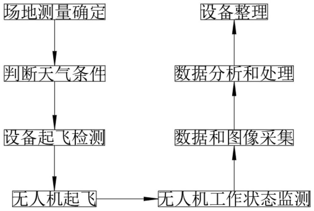
[0035] UAV audio measurement method, such as figure 1 As shown, including the following steps:
[0036] S1: Site Measurement Determination: Arrival at the scene, identify the range of measurement regions, and analyze the measurement area satellite map;
[0037] S2: Judgment weather conditions: Observe the measurement weather, select cloudy weather or high brightness, and the illumination should increase the exposure time, the ISO value low represents the quality of the imaging, and the site wind speed, the ground four-stage wind and the ground Suitable, anti-wind, wind, temperature 0 ° C -40 ° C, temperature too high or too low affect battery stability and camera accuracy, and record information such as wind speed, weather, take-off and landing coordinates, check the date of data reference and analysis to sum up;
[0038] S3: Equipment Test: The remote control is inserted into the 4G network card, and the SIM card installation check, the CORS connection signal check, and check the...
Embodiment 2
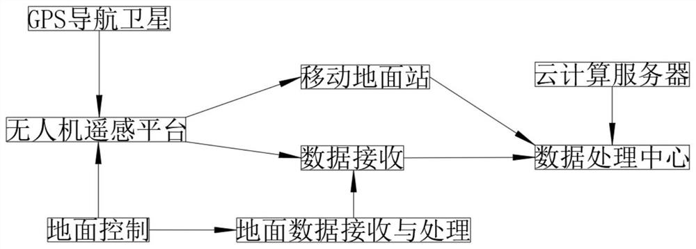
[0048] A system, such as figure 2 As shown, including GPS navigation satellite, drone remote sensing platform, ground control, data receiving module, mobile ground station and cloud computing server, the GPS navigation satellite is connected to the drone body with the drone body via the GPS reception and the transmitter. The human-machine rocker platform is connected to the mobile ground station through the wireless communication network, and the ground control is connected to the drone through the wireless module and the repeater, and the ground control includes ground data accepting and processing modules, and the cloud computing server contains data. The processing center, the mobile floor station is connected to the data processing center through the wireless network, and the drone remote sensing platform and the ground data accept and processing modules are connected to the data receiving module via the wireless network.
[0049] The data reception and processing module inclu...
PUM
 Abstract
Description
Claims
Application Information
 - R&D
- Intellectual Property
- Life Sciences
- Materials
- Tech Scout
- Unparalleled Data Quality
- Higher Quality Content
- 60% Fewer Hallucinations
Browse by: Latest US Patents, China's latest patents, Technical Efficacy Thesaurus, Application Domain, Technology Topic, Popular Technical Reports.
© 2025 PatSnap. All rights reserved.Legal|Privacy policy|Modern Slavery Act Transparency Statement|Sitemap|About US| Contact US: help@patsnap.com


